
Legazpi is an administrative neighborhood (barrio) of Madrid belonging to the district of Arganzuela. It has an area of 1.396410 km2 (0.539157 sq mi). As of 1 February 2020, it has a population of 19,820.

Adelfas is an administrative neighborhood (barrio) of Madrid belonging to the district of Retiro. It has an area of 0.640692 km2 (0.247373 sq mi). As of 1 February 2020, it has a population of 18,886.

Ibiza is an administrative neighborhood (barrio) of Madrid belonging to the district of Retiro. It has an area of 0.490863 km2 (0.189523 sq mi). As of 1 February 2020, it has a population of 22,050. The building complex of the Hospital General Universitario Gregorio Marañón is located in the neighborhood.

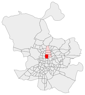
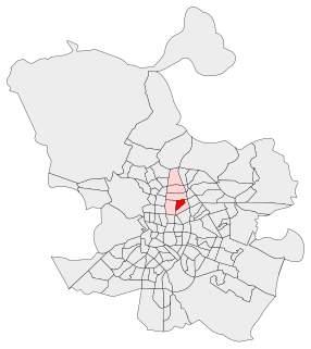
Guindalera or La Guindalera is an administrative neighborhood (barrio) of Madrid belonging to the district of Salamanca. It has an area of 1.598962 km2 (0.617363 sq mi). As of 1 March 2020, it has a population of 42,516.
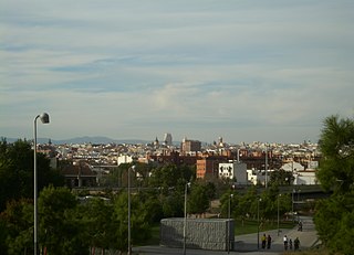
El Viso is a neighborhood of Madrid, part of the Chamartín District. Consisting mainly of residential detached houses, it is currently the wealthiest neighborhood of the Spanish capital, overtaking the Salamanca District. Aristocrats, businessmen, politicians and diplomats have inhabited this area for half a century. The neighborhood also hosts the main headquarters of the Spanish National Research Council (CSIC).
Ciudad Jardín is a neighborhood (barrio) of the Chamartín district, situated in the northeast part of the city of Madrid and adjacent to the Salamanca district. It is located between Calle Príncipe de Vergara, Avenida Ramón y Cajal and Calle López de Hoyos, the latter being one of the longest streets in the city and well known for its great commercial activity.

Cuatro Caminos is a neighborhood (barrio) of Madrid belonging to the district of Tetuán.

Castillejos is an administrative neighborhood of Madrid located in the district of Tetuán. It has an area of 0.708501 km2 (0.273554 sq mi). As of February 2020, it has a population of 20,870.

Trafalgar is an administrative neighborhood (barrio) of Madrid belonging to the district of Chamberí. It has an area of 0.611950 km2 (0.236275 sq mi). As of 1 February 2020, it has a population of 25,117.
Vallehermoso is an administrative neighborhood (barrio) of Madrid belonging to the district of Chamberí. It has an area of 1.068709 km2 (0.412631 sq mi). As of 1 February 2020, it has a population of 20,480. The Vallehermoso Stadium, the traditional venue in the city for athletics competitions and re-opened in 2019, is located in the neighborhood.
Puerta Bonita is an administrative neighborhood (barrio) of Madrid belonging to the district of Carabanchel. It has an area of 1.607994 km2 (0.620850 sq mi). With an area of 0.45 km2 (0.17 sq mi), the Quinta of Vistalegre, which is chiefly owned by the regional administration, spreads over much of the neighborhood. The name of the neighborhood comes from a former iron gate of the quinta, which was accidentally destroyed in 1982. As of 1 February 2020, it has a population of 36,157.

Abrantes is an administrative neighborhood (barrio) of Madrid belonging to the district of Carabanchel. It has an area of 1.564207 km2 (0.603944 sq mi). As of 1 February 2020, it as a population of 32,145. The Emperatriz María de Austria Park, 0.597458 km2 (0.230680 sq mi) in size, spreads across a large part of the neighborhood.
Orcasur is an administrative neighborhood (barrio) of Madrid belonging to the district of Usera. It has an area of 1.384234 km2 (0.534456 sq mi). As of 1 March 2020, it has a population of 14,264. The Hospital Universitario 12 de Octubre is located in the neighborhood.

Palomeras Bajas is an administrative neighborhood (barrio) of Madrid belonging to the district of Puente de Vallecas. It has an area of 1.724430 km2 (0.665806 sq mi). As of 1 February 2020, it has a population of 41,034. The seat of the Assembly of Madrid, the regional legislature of the Community of Madrid, is located in the neighborhood.

Portazgo is an administrative neighborhood (barrio) of Madrid belonging to the district of Puente de Vallecas. It has an area of 1.245274 km2 (0.480803 sq mi). As of 1 February 2020, it has a population of 29,094.

Horcajo is an administrative neighborhood (barrio) of Madrid belonging to the district of Moratalaz. It has an area of 0.745503 km2 (0.287840 sq mi). As of 1 February 2020, it has a population of 6,453.

Santa Eugenia is an administrative neighborhood (barrio) of Madrid belonging to the district of Villa de Vallecas. It has an area of 2.070637 km2 (0.799477 sq mi). As of 1 March 2020, it has a population of 24,782. The Hospital Universitario Infanta Leonor is located in the neighborhood.
Simancas is an administrative neighborhood (barrio) of Madrid belonging to the district of San Blas-Canillejas. It has an area of 2.278418 km2 (0.879702 sq mi). As of 1 February 2020, it has a population of 28,799.

Salvador is an administrative neighborhood (barrio) of Madrid belonging to the district of San Blas-Canillejas. It has an area of 1.881765 km2 (0.726554 sq mi). As of 1 February 2020, it has a population of 11,516.

Casco Histórico de Barajas is an administrative neighborhood (barrio) of Madrid belonging to the district of Barajas. It has an area of 0.609202 km2 (0.235214 sq mi). As of 1 February 2020, it has a population of 7,735.

