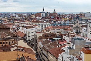
Centro is a district of Madrid, Spain. It is approximately 5.23 km2 in size. It has a population of 149,718 people and a population density of 28,587/km2. It roughly corresponds to the bulk of the housing formerly enclosed by the so-called Walls of Philip IV. The district is made up of the neighbourhoods of Cortes, Embajadores, Justicia, Universidad, Palacio and Sol.

Canillejas is an administrative neighborhood (barrio) of Madrid, belonging to the San Blas-Canillejas district. It is named after the former namesake municipality, absorbed by Madrid in 1949. It has an area of 1.598075 km2 (0.617020 sq mi). As of 1 March 2020, it has a population of 29,288.
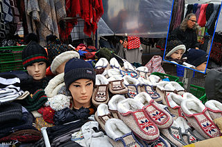
El Rastro de Madrid or simply el Rastro is the most popular open air flea market in Madrid (Spain). It is held every Sunday and public holiday during the year and is located along Plaza de Cascorro and Ribera de Curtidores, between Calle Embajadores and the Ronda de Toledo.
Tetuán is a district of Madrid, Spain.

The Chocolatería San Ginés is a café at Pasadizo de San Ginés, 5, in central Madrid, in a passageway close to San Ginés church, west of the Puerta del Sol. It has served principally chocolate con churros since 1894. Coffee and cakes are also available.
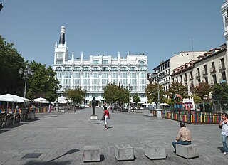
Plaza de Santa Ana is a plaza located in central Madrid, Spain, nearby Puerta del Sol and Calle de Huertas, in the Barrio de las Letras. It features monuments to Spanish Golden Age writer Pedro Calderón de la Barca and to the poet and playwright Federico García Lorca and numerous restaurants, cafes and tapas bars, with its terraces covering most of the sides surfaces.

Atocha is an administrative neighborhood of Madrid belonging to the district of Arganzuela.

Almenara, also popularly known by the name of La Ventilla, is an administrative neighborhood of Madrid located in the district of Tetuán. It has an area of 0.999369 km2 (0.385859 sq mi). As of February 2020, it has a population of 23,114. The Avenida de Asturias crosses the area.

Embajadores is an administrative neighborhood (barrio) of Madrid, belonging to the Centro District.

Fuente del Berro is an administrative neighborhood (barrio) of Madrid belonging to the district of Salamanca. It has an area of 0.852579 km2 (0.329183 sq mi). As of 1 March 2020, it has a population of 21,341. The park of the Quinta de la Fuente del Berro and El Pirulí are located in the neighborhood.

El Viso is a neighborhood of Madrid, part of the Chamartín District. Consisting mainly of residential detached houses, it is currently the wealthiest neighborhood of the Spanish capital, overtaking the Salamanca District. Aristocrats, businessmen, politicians and diplomats have inhabited this area for half a century. The neighborhood also hosts the main headquarters of the Spanish National Research Council (CSIC).

Bellas Vistas is an administrative neighborhood of Madrid, part of the district of Tetuán. It has an area of 0.716261 km2 (0.276550 sq mi). As of 1 February 2020, it has a population of 29,993. It was created as slum of the north of the city, on the west side of the Road of France, currently the calle de Bravo Murillo.

Cuatro Caminos is an administrative neighborhood of Madrid belonging to the district of Tetuán. It has an area of 1.193509 km2 (0.460816 sq mi). As of 1 February 2020, it has a population of 35,395. It was created as slum of the north of the city, on the east side of the Road of France, currently the calle de Bravo Murillo.

Arapiles is an administrative neighborhood (barrio) of Madrid belonging to the district of Chamberí. It has an area of 0.578534 km2 (0.223373 sq mi). As of 1 February 2021, it has a population of 24,348.

Valverde is an administrative neighborhood (barrio) of Madrid belonging to the district of Fuencarral-El Pardo. It has an area of 8.977802 km2 (3.466349 sq mi). As of 1 March 2020, it has a population of 65,022. The historic centre of Fuencarral, belongs to the Valverde neighborhood. The Hospital Universitario Ramón y Cajal is also located in the neighborhood.

Argüelles is an administrative neighborhood of Madrid belonging to the district of Moncloa-Aravaca. As of 1 July 2019, it had a population of 24,257 inhabitants. It is 0,755758 km2 in total area.
Orcasur is an administrative neighborhood (barrio) of Madrid belonging to the district of Usera. It has an area of 1.384234 km2 (0.534456 sq mi). As of 1 March 2020, it has a total population of 14,264. The Hospital Universitario 12 de Octubre is located in the neighborhood.

Ventas is an administrative neighborhood (barrio) of Madrid belonging to the district of Ciudad Lineal.

Ambroz was an administrative neighborhood of Madrid belonging to the district of Vicálvaro. In 2017, through approval of Madrid's city council, the territory became part of the Casco Histórico de Vicálvaro neighborhood.

Rosas is an administrative neighborhood of Madrid belonging to the district of San Blas-Canillejas.