The Manzanares is a river in the centre of the Iberian Peninsula, which flows from the Sierra de Guadarrama, passes through Madrid, and eventually empties into the Jarama river, which in turn is a right-bank tributary to the Tagus.
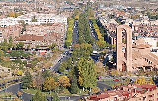
Pozuelo de Alarcón is a municipality in the Community of Madrid, Spain. Bordering the Moncloa-Aravaca district of Madrid proper to its west, Pozuelo de Alarcón is surrounded by large Mediterranean pine-tree forests: the Casa de Campo, the Monte del Pardo, and the Monte del Pilar. As of 2019, it ranks as the wealthiest municipality in Spain. La Finca, an isolated luxury residential area known by its affluent residents, most notably football players, lies within the municipality bounds.

Getafe is a city in the Community of Madrid, Spain. As of 2018, it has a population of 180,747, the region's sixth most populated municipality.

The Zarzuela Palace is the residence and working offices of the reigning monarch of Spain, although the official residence of the Spanish royal family is the Royal Palace of Madrid. The Zarzuela Palace is on the outskirts of Madrid, near the Royal Palace of El Pardo, which accommodates visiting heads of state. The palace is owned by the Spanish government and administered by a state agency named Patrimonio Nacional.

San Juan del Cesar is a municipality and town located in the La Guajira Department, Colombia.

The Sierra de Guadarrama is a mountain range forming the main eastern section of the Sistema Central, the system of mountain ranges along the centre of the Iberian Peninsula. It is located between the systems Sierra de Gredos in the province of Ávila, and Sierra de Ayllón in the province of Guadalajara.

The Royal Palace of El Pardo is a historic building in Madrid, Spain, in the present-day district of Fuencarral-El Pardo. It is owned by the Spanish state and administered by the Patrimonio Nacional agency. It serves as the state guest house of the Spanish Government.
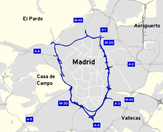
The M-30 orbital motorway circles the central districts of Madrid, the capital city of Spain. It is the innermost ring road of the Spanish city, with a length of 32.5 km. Outer rings are named M-40, M-45 and M-50. Its length and the surface surrounded by the M-30 is comparable to the Boulevard Périphérique of Paris or the London Inner Ring Road.

Torrelodones is a municipality in the northwest of the Autonomous Community of Madrid, Spain. It is situated 29 kilometers northwest from the city of Madrid. Because of its location between the Sierra de Guadarrama and the metropolitan area of the capital, it is linked to two districts in Madrid: the agricultural area of Guadarrama and the metropolitan area of Madrid.

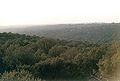
The Monte de El Pardo is a large forested area in Madrid, Spain, extending roughly across one quarter of the total municipal area.

Fuencarral-El Pardo is one of the 21 districts that form the city of Madrid, Spain.
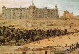
The Royal Alcázar of Madrid was a fortress located at the site of today's Royal Palace of Madrid, Madrid, Spain. The structure was originally built in the second half of the ninth century by the Muslims, then extended and enlarged over the centuries, particularly after 1560. It was at this time that the fortress was converted into a royal palace, and Madrid became the capital of the Spanish Empire. Despite being a palace, the great building kept its original arabic title of Alcázar.

Soto de Viñuelas is a meadow-oak forest north of the city of Madrid, south of Tres Cantos and San Agustín del Guadalix, east of the Monte de El Pardo and west of San Sebastián de los Reyes, all municipalities are parts of the Community of Madrid, Spain. Much of it is a fenced property of 3,000 hectares, which includes important ecological values, landscape and art. It belongs to the municipality of Madrid, although it contains small areas to the north, corresponding to Tres Cantos, including a development of the same name. Other developments nearby are Ciudalcampo and Fuente del Fresno, situated on its western boundary. King's College, the British School of Madrid, is also located in the development of Soto de Viñuelas, abutting the Regional Park. In 1985 Soto de Viñuelas was turned into the Regional Park of the Cuenca Alta del Manzanares, the largest protected natural area in the region. It has been classified as Area B, a legal instrument that allows agricultural land use. Soto de Viñuelas also received the status of Special Protection Area for Birds. It is accessed from the M-607 Freeway, exit 20. Soto de Viñuelas and Tres Cantos are both listed on the exit sign.

The New Castle of Manzanares el Real, also known as Castle of los Mendoza, is a palace-fortress erected in the 15th century in the town of Manzanares el Real, next to the Santillana reservoir at the foot of Sierra de Guadarrama mountain range.
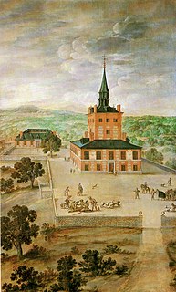
The Torre de la Parada is a former hunting lodge that was located in present-day Monte de El Pardo in Fuencarral-El Pardo, near the Royal Palace of El Pardo, some way outside Madrid in the Sierra de Guadarrama. It was mostly destroyed by fire when taken in 1714 by Austrian troops in the War of Spanish Succession, though the ruins remain.

Puerta de Hierro is a monument of the second half of the 18th century, located in the northwest of Madrid, Spain, in the district of Moncloa near the Monte de El Pardo. It occupies a landscaped traffic island, defined by several branches of the highway A-6 and M-30, an enclave which is difficult to access. It is built in classical Baroque style.
Valdemarín is a ward (barrio) of Madrid belonging to the district of Moncloa-Aravaca. Its code number is 95 and, as of 2006, its population was of 4,000.

Madrid is the capital and most populous city of Spain. The city has almost 3.4 million inhabitants and a metropolitan area population of approximately 6.7 million. It is the second-largest city in the European Union (EU), surpassed only by Berlin in its administrative limits, and its monocentric metropolitan area is the second-largest in the EU, surpassed only by Paris. The municipality covers 604.3 km2 (233.3 sq mi) geographical area.

The Walls of Madrid are the five successive sets of walls that surrounded the city of Madrid from the Middle Ages until the end of the 19th century. Some of the walls had a defensive or military function, while others made it easy to tax goods entering the city. Towards the end of the 19th century the demographic explosion that came with the Industrial Revolution prompted urban expansion throughout Spain. Older walls were torn down to enable the expansion of the city under the grid plan of Carlos María de Castro.

The Muslim Walls of Madrid, of which some vestiges remain, are located in the Spanish city of Madrid. They are probably the oldest construction extant in the city. They were built in the 9th century, during the Muslim domination of the Iberian Peninsula, on a promontory next to Manzanares river. They were part of a fortress around which developed the urban nucleus of Madrid. They were declared an Artistic-Historic Monument in 1954.