
Tooele County is a county in the U.S. state of Utah. As of the 2020 United States Census, the population was 72,698. Its county seat and largest city is Tooele. The county was created in 1850 and organized the following year.

The Wasatch Range or Wasatch Mountains is a mountain range in the western United States that runs about 160 miles (260 km) from the Utah-Idaho border south to central Utah. It is the western edge of the greater Rocky Mountains, and the eastern edge of the Great Basin region. The northern extension of the Wasatch Range, the Bear River Mountains, extends just into Idaho, constituting all of the Wasatch Range in that state.

The Great Basin Desert is part of the Great Basin between the Sierra Nevada and the Wasatch Range. The desert is a geographical region that largely overlaps the Great Basin shrub steppe defined by the World Wildlife Fund, and the Central Basin and Range ecoregion defined by the U.S. Environmental Protection Agency and United States Geological Survey. It is a temperate desert with hot, dry summers and snowy winters. The desert spans large portions of Nevada and Utah, and extends into eastern California. The desert is one of the four biologically defined deserts in North America, in addition to the Mojave, Sonoran, and Chihuahuan Deserts.

The Uinta Mountains are an east-west trending chain of mountains in northeastern Utah extending a short distance into northwest Colorado and slightly into southwestern Wyoming in the United States. As a subrange of the Rocky Mountains, they are unusual for being the highest range in the contiguous United States running east to west, and lie approximately 100 miles (160 km) east of Salt Lake City. The range has peaks ranging from 11,000 to 13,528 feet, with the highest point being Kings Peak, also the highest point in Utah. The Mirror Lake Highway crosses the western half of the Uintas on its way to Wyoming. Utah State Route 44 crosses the east end of the Uintas between Vernal and Manila.

Mount Timpanogos, often referred to as Timp, is the second-highest mountain in Utah's Wasatch Range. Timpanogos rises to an elevation of 11,752 ft (3,582 m) above sea level in the Uinta-Wasatch-Cache National Forest. With 5,270 ft (1,610 m) of topographic prominence, Timpanogos is the 47th-most prominent mountain in the contiguous United States.

The Desolation Wilderness is a 63,960-acre (258.8 km2) federally protected wilderness area in the Eldorado National Forest and Lake Tahoe Basin Management Unit, in El Dorado County, California. The crest of the Sierra Nevada runs through it, just west of Lake Tahoe.

Bitterroot National Forest comprises 1.587 million acres (6,423 km2) in west-central Montana and eastern Idaho of the United States. It is located primarily in Ravalli County, Montana, but also has acreage in Idaho County, Idaho (29.24%), and Missoula County, Montana (0.49%).

Wasatch–Cache National Forest is a United States National Forest located primarily in northern Utah (81.23%), with smaller parts extending into southeastern Idaho (16.42%) and southwestern Wyoming (2.35%). The name is derived from the Ute word Wasatch for a low place in high mountains, and the French word Cache meaning to hide. The term cache originally referred to fur trappers, the first Europeans to visit the land. The Wasatch–Cache National Forest boundaries include 1,607,177 acres (6,504.01 km2) of land.

The Lone Peak Wilderness is a 30,088-acre (121.76 km2) wilderness area located within the Uinta and the Wasatch-Cache National Forests in the U.S. state of Utah.

Wasatch National Forest was established as the Wasatch Forest Reserve by the U.S. Forest Service in Utah on August 16, 1906 with 86,440 acres (349.8 km2) to the east of Salt Lake City and Provo. It became a National Forest on March 4, 1907. On July 1, 1908 Grantsville National Forest and Salt Lake National Forest were added. In 1973 Wasatch was combined administratively with Cache National Forest, creating Wasatch-Cache National Forest. In descending order of acreage, the Wasatch National Forest portion is located in Summit, Tooele, Salt Lake, Davis, Uinta (Wyoming), Duchesne, Wasatch, Morgan, Utah, Weber, and Juab counties in Utah except Uinta, which is in southwestern Wyoming. Its total area was 908,731 acres (3,677.50 km2), comprising 56.44% of the combined Wasatch-Cache's 1,610,184 acres (6,516.18 km2) as of 2008. There are local ranger district offices in Kamas and Salt Lake City in Utah, and in Evanston and Mountain View in Wyoming. Administrative headquarters reside with the combined Uinta-Wasatch-Cache National Forest in South Jordan, Utah.

Deseret Peak is the highest peak in the Stansbury Mountains with an elevation of 11,035 ft. It is located in the Deseret Peak Wilderness area west of Grantsville, Utah and east of Skull Valley Indian Reservation. It is the fourth most topographically prominent peak in the state of Utah. The site is a popular destination for hikers and backcountry skiers as the area is a contrast of the alpine wilderness with the surrounding desert basin. The trail that leads to the peak is easily accessible from Salt Lake City. The mountain offers views of the Bonneville Salt Flats, the Great Salt Lake, and the surrounding towns and mountain ranges. On a clear day, it is possible to see Mount Nebo, the highest peak in the adjacent Wasatch Mountains.

The Uinta Highline Trail is a trail in the Uinta Mountains of Utah that traverses the range 104 miles (167 km) from east to west. The trail passes through expansive alpine landscapes dominated by metasedimentary rocks sculpted by past glaciers. The broad glacial basins are dotted by hundreds of lakes.
The Piper Mountain Wilderness is a federally designated wilderness area located in the White Mountains 20 miles (32 km) northeast of Big Pine, California in Inyo County, California.

The High Uintas Wilderness is a wilderness area located in northeastern Utah, United States. The wilderness covers the Uinta Mountains, encompassing parts of Duchesne and Summit counties. Designated as a wilderness in 1984, the area is located within parts of Ashley National Forest and Uinta-Wasatch-Cache National Forest, managed by the U.S. Forest Service. The highest peak in Utah, Kings Peak, lies within the wilderness area along with some of Utah's highest peaks, particularly those over 13,000 feet.

Mount Timpanogos Wilderness is a 10,518-acre (42.56 km2) wilderness area protecting Mount Timpanogos and the surrounding area. It is located in the front range of the Wasatch Mountain Range, between American Fork Canyon on the north and Provo Canyon on the south, within the Uinta-Wasatch-Cache National Forest on the north eastern edge of Utah County, Utah, United States. The wilderness area receives fairly heavy use due to its proximity to the heavily populated cities of Provo and Salt Lake City. It is bordered on the north by the Lone Peak Wilderness.

The Dardanelles and Freel Roadless Areas are located 7 miles (11 km) and 3 miles (4.8 km), respectively, south of Lake Tahoe, California, and both are managed by the Lake Tahoe Basin Management Unit of the US Forest Service.These areas are contiguous, separated only by the corridor of highway 89. The historic Hawley Grade, an immigrant wagon road, now a hiking trail, is within the Dardanelles Roadless Area, as well as the watershed of Lake Tahoe's largest inflow, the Upper Truckee River.
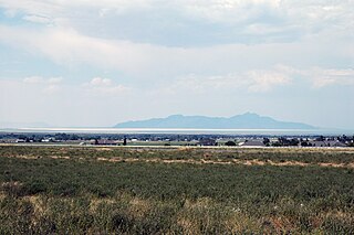
Stansbury Island is the second largest island within the Great Salt Lake in the U.S. state of Utah. Located in Tooele County, it is considered an island even though a dirt causeway connects it to the mainland. Stansbury Island was named after Howard Stansbury, the leader of a government expedition that surveyed the lake in 1849.
Howard Stansbury was a major in the U.S. Army Corps of Topographical Engineers. His most notable achievement was leading a two-year expedition (1849–1851) to survey the Great Salt Lake and its surroundings. The expedition report entitled Exploration and survey of the valley of the Great Salt Lake of Utah, including a reconnaissance of a new route through the Rocky Mountains was published in 1852 providing the first serious scientific exploration of the flora and fauna of the Great Salt Lake Valley as well as a favorable impression of the members of the Church of Jesus Christ of Latter-day Saints, who had settled there beginning in 1847.

The Stansbury Mountains are a 28-mile (45 km) long mountain range located in eastern Tooele County, Utah. It is named for U.S. Army Major Howard Stansbury, a topographical engineer, who led an expedition that surveyed the region.


