Snow Canyon State Park

Last updated
Snow Canyon State Park
IUCN category V (protected landscape/seascape)
Snow Canyon Utah March 2019.jpg
Snow Canyon State Park
USA Utah relief location map.svg
Red pog.svg
Location of Snow Canyon State Park in Utah
Usa edcp relief location map.png
Red pog.svg
Snow Canyon State Park (the United States)
Location Washington, Utah, United States
Coordinates 37°12′11″N113°38′29″W / 37.20306°N 113.64139°W / 37.20306; -113.64139 Coordinates: 37°12′11″N113°38′29″W / 37.20306°N 113.64139°W / 37.20306; -113.64139
Area7,400 acres (30 km2) [1]
Established1958
Named for Lorenzo and Erastus Snow
Visitors344,915(in 2011) [2]
OperatorUtah State Parks

Snow Canyon State Park is a state park in Utah, located in the Red Cliffs Desert Reserve. [1] The park features a canyon carved from the red and white Navajo sandstone of the Red Mountains, as well as the extinct Santa Clara Volcano, lava tubes, lava flows, and sand dunes. Snow Canyon is located near the cities of Ivins and St. George in Washington County.

Contents

Description

Snow Canyon State Park contains several sandstone canyons cut in the Red Mountains. On the north end of the park, West Canyon and Snow Canyon follow a parallel southward path and converge in the middle of the park. The park then continues south-by-southeastward as a single, larger canyon, that opens near the park's southern entrance out onto the Santa Clara bench near Ivins, Utah. [3]

Red rock formations are a major feature of the canyon. Snow Canyon 4.JPG
Red rock formations are a major feature of the canyon.

A paved two-lane road (formerly SR-300) enters the park from Ivins on the south, winds up the canyon, then climbs the eastern edge to the bench above Snow Canyon. There the road joins State Route 18. The park boundaries extend northeastward across State Route 18 to encompass two cinder cones along the western edge of Diamond Valley.

The highest point in the park, according to a U.S. Geological Survey topographical map, is a 5,024-foot (1,531 m) peak west of the southern cinder cone, above the eastern edge of the east fork of Snow Canyon.

Park Facilities

Snow Canyon State Park is used for activities such as hiking, mountain biking, and horseback riding, and is open year-round. [4] It contains 17 multi-use campsites and 14 sites for RVs. [5] The day-use fee is $10 for Utah residents. [6] Hikers and bikers may obtain annual passes for $100. [7] The Johnson Canyon trail, which leads to a large arch, may be accessed without payment of fees, but is closed to hikers most of the year for wildlife and habitat protection. The Johnson Canyon trail is usually open from October to March. [8]

Climate

Morning breaks over Snow Canyon State Park. Picture taken from an overlook just off of Utah State Route 18 Snowcynsmall.jpg
Morning breaks over Snow Canyon State Park. Picture taken from an overlook just off of Utah State Route 18

Snow Canyon sits at the junction of the Mojave Desert, Great Basin, and Colorado Plateau. The desert climate means the canyon receives little rainfall, averaging 7.5 inches per year, and can experience very high summer temperatures. [9] [1]

The average temperature in the nearby town of Ivins shows summer low temperatures of around 68 °F (20 °C) and highs of 101 °F (38 °C). Winters experience average lows around 30 °F (−1 °C) and highs around 55 °F (13 °C). [10]

History

Snow Canyon has had human activity since the 5th century BC. From AD 200 to 1250, Ancestral Puebloans inhabited the nearby region, utilizing the canyon for hunting and gathering. Southern Paiute used the canyon from AD 1200 to the mid-19th century. According to local stories, Mormon pioneers first came upon Snow Canyon in the 1850s while looking for lost cattle. [11]

Snow Canyon was designated a state park in 1958, and was one of the first inclusions in the state park system, created the year before. [9] In 1959, the area of the park grew from the donation of 296 acres from Washington County to the State Parks Commission, and was subsequently increased with the purchases of nearby ranches. Originally called Dixie State Park, it was later renamed for Lorenzo and Erastus Snow, prominent pioneering Utah leaders. [1] [11]

The park was first opened to the public in 1962. [12] During the 1960s the park continued to grow via additional land purchases as well as the transfer of nearly 4,000 acres of federal land from the Bureau of Land Management to the State of Utah. [11]

Many Hollywood films have been filmed at least partly in Snow Canyon. These include The Conqueror (1956) starring John Wayne, The King and Four Queens (1956), Butch Cassidy and the Sundance Kid (1969), The Electric Horseman (1979), Jeremiah Johnson (1972), Run of the Arrow (1957), They Came to Cordura (1959), The Appaloosa (1966), Six Black Horses (1962), Bullet for a Badman (1964), Gunpoint (1966), The Flintstones (1994), and High School Musical 2 (2007). [13] [11]

Flora and fauna

Various types of desert shrubs are found in the park against the rock formations Snow Canyon 2.JPG
Various types of desert shrubs are found in the park against the rock formations

Snow canyon is home to several mammal species, including coyotes, kit foxes, antelope ground squirrels, and bobcat. [14] [15] Common birds in the park are greater roadrunners, common ravens, Bewick's and canyon wren, and Gambel's quail. [16] The park is also home to lizards, snakes, and amphibians, including desert spiny lizards and canyon tree frogs. There are thirteen sensitive species protected by law within the park, including peregrine falcons, desert tortoises, and gila monsters. [14] Small fences to keep the ground-dwelling creatures from accidentally wandering onto roads can be seen across Snow Canyon.

Plants in the park include the desert species creosote, narrow-leaf yucca, pinyon pine, shrub live oak, desert almond, mormon tea, strawberry hedgehog cactus, among others. Wildflower blooms are visible in fall and spring, when conditions are right. [14] [17]

Trails

Whiptail Trail - 6 miles (9.7 km). Easy. Level with some slopes. Accessible to physically challenged. Tucked along the canyon bottom, this sinuous paved trail is suitable for hiking, jogging, biking and rollerblading.

Johnson Canyon - (Open November 15 to March 1 only) - 2 miles (3.2 km). Easy. Level with some rocky slopes and steps. Boasting the only riparian area in the park, this trail winds through lava flows and red rock to an arch spanning 200 feet (61 m).

Jenny's Canyon - (Closed March 31 to June 1) - 0.5 miles (0.80 km). Easy, level with few slopes and steps. Trail leads to a narrow, sculpted canyon then splits with rock stairsteps to offer a scenic overlook.

Sand Dunes - 0.5 miles (0.80 km). Easy. Deep sand with some slopes. Trail leads to a large expanse of red sand that is an excellent play area for children of all ages.

White Navajo Sandstone petrified sand dune. Snow Canyon 3.JPG
White Navajo Sandstone petrified sand dune.

West Canyon Road - 7 miles (11 km). Easy. Gravel and sand surface. Fairly level. Trail follows a maintenance road winding past washes and towering cliffs to the mouth of present-day Snow Canyon.

Pioneer Names - 0.5 miles (0.80 km). Easy. Fairly level with some steps and slopes. This crescent-shaped trail passes pioneer names written in axle grease, dating back to 1883.

Hidden Pinyon - 1.5 miles (2.4 km). Moderate. Rocky slopes. Drop-offs. This self-guided nature trail introduces geological features and native plants of the park.

Three Ponds - 3.5 miles (5.6 km). Moderate. Some rocky slopes. Deep sand. Trail winds through sandy washes to mouth of a 400-foot (120 m) canyon. Potholes eroded in sandstone catch seasonal rain, giving the trail its name.

Petrified Dunes Trail - 1-mile (1.6 km). Moderate. Some steep slopes, uneven surfaces. This trail crosses massive sandstone outcrops where you may explore sand dunes frozen in time.

Butterfly Trail - 2 miles (3.2 km). Moderate. Some steep slopes, steps and uneven surfaces. Winding along the west side of Petrified Dunes, this trail leads to West Canyon Overlook and lava tubes.

White Rocks Trail/Lava Flow Overlook - 4 miles (6.4 km). Moderate. Some rocky slopes, uneven surfaces. Passing through lava flows, juniper stands and views of West Canyon, trail leads to a natural amphitheater set in white sandstone. Or reach the amphitheater on a 1-mile (1.6 km) trail located one-half mile north of State Route 18 junction.

Scene from Snow Canyon Lava Tubes Hike Snow Canyon Natural Scene.jpg
Scene from Snow Canyon Lava Tubes Hike
150627053448 Snow Canyon.jpg
Panorama of Snow Canyon

Related Research Articles

Ivins, Utah City in Utah, United States

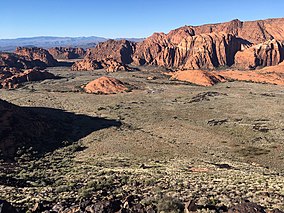
Ivins is a city in southwestern Washington County, Utah, United States. It is a part of the St. George Metropolitan Area as a suburb or "bedroom" community. The population was 6,753 at the 2010 census, and it was estimated at 8,913 in 2018. Although Ivins was listed as a town in the 2000 census, it became a city in 1998.

Red Rock Canyon National Conservation Area National conservation area in Nevada

The Red Rock Canyon National Conservation Area in Clark County, Nevada, is an area managed by the Bureau of Land Management as part of its National Landscape Conservation System, and protected as a National Conservation Area. It is about 15 miles (24 km) west of Las Vegas, and is easily seen from the Las Vegas Strip. More than three million people visit the area each year.

Mogollon Rim Escarpment of the Colorado Plateau in Arizona, US

The Mogollon Rim is a topographical and geological feature cutting across the northern half of the U.S. state of Arizona. It extends approximately 200 miles (320 km), starting in northern Yavapai County and running eastward, ending near the border with New Mexico. It forms the southern edge of the Colorado Plateau in Arizona.

Capitol Reef National Park National park in Utah, United States

Capitol Reef National Park is an American national park in south-central Utah. The park is approximately 60 miles (97 km) long on its north–south axis and just 6 miles (9.7 km) wide on average. The park was established in 1971 to preserve 241,904 acres of desert landscape and is open all year, with May through September being the highest visitation months.

Geology of the Zion and Kolob canyons area Geology of Zion National Park in Utah

The geology of the Zion and Kolob canyons area includes nine known exposed formations, all visible in Zion National Park in the U.S. state of Utah. Together, these formations represent about 150 million years of mostly Mesozoic-aged sedimentation in that part of North America. Part of a super-sequence of rock units called the Grand Staircase, the formations exposed in the Zion and Kolob area were deposited in several different environments that range from the warm shallow seas of the Kaibab and Moenkopi formations, streams and lakes of the Chinle, Moenave, and Kayenta formations to the large deserts of the Navajo and Temple Cap formations and dry near shore environments of the Carmel Formation.

Colorado National Monument National Park Service unit in Colorado, United States

Colorado National Monument is a National Park Service unit near the city of Grand Junction, Colorado. Sheer-walled canyons cut deep into sandstone and granite–gneiss–schist rock formations. This is an area of desert land high on the Colorado Plateau, with pinyon and juniper forests on the plateau. The park hosts a wide range of wildlife, including red-tailed hawks, golden eagles, ravens, jays, desert bighorn sheep, and coyotes. Activities include hiking, horseback riding, road bicycling, and scenic drives; a visitor center on the west side contains a natural history museum and gift shop. There are scenic views from trails, Rim Rock Drive, which winds along the plateau, and the campground. Nearby are the Book Cliffs and the largest flat-topped mountain in the world, the Grand Mesa.

Goblin Valley State Park State park in Utah, United States

Goblin Valley State Park is a state park of Utah, in the United States. The park features thousands of hoodoos, referred to locally as goblins, which are formations of mushroom-shaped rock pinnacles, some as tall as several yards (meters). The distinct shapes of these rocks result from an erosion-resistant layer of rock atop relatively softer sandstone. Goblin Valley State Park and Bryce Canyon National Park, also in Utah about 190 miles (310 km) to the southwest, contain some of the largest occurrences of hoodoos in the world.

Geology of the Canyonlands area

The exposed geology of the Canyonlands area is complex and diverse; 12 formations are exposed in Canyonlands National Park that range in age from Pennsylvanian to Cretaceous. The oldest and perhaps most interesting was created from evaporites deposited from evaporating seawater. Various fossil-rich limestones, sandstones, and shales were deposited by advancing and retreating warm shallow seas through much of the remaining Paleozoic.

Geology of the Capitol Reef area

The exposed geology of the Capitol Reef area presents a record of mostly Mesozoic-aged sedimentation in an area of North America in and around Capitol Reef National Park, on the Colorado Plateau in southeastern Utah.

Places of interest in the Death Valley area

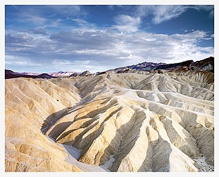
Places of interest in the Death Valley area are mostly located within Death Valley National Park in eastern California.

The Wave (Arizona) Rock formation in the Vermilion Cliffs National Monument in Arizona, US

The Wave is a sandstone rock formation located in Arizona, United States, near its northern border with Utah. The formation is situated on the slopes of the Coyote Buttes in the Paria Canyon-Vermilion Cliffs Wilderness of the Colorado Plateau. The area is administered by the Bureau of Land Management (BLM) at the Grand Staircase-Escalante National Monument visitor center in Kanab, Utah.

Black Ridge Canyons Wilderness

The Black Ridge Canyons Wilderness (BRCW) is located in western Colorado with a small portion extending into eastern Utah, USA, within the arid Colorado Plateau region approximately 15 miles (24 km) west of Grand Junction, Colorado. The wilderness lies on the northwest flank of the Uncompahgre Plateau. It is characterized by the high, east-west trending Black Ridge dissected by seven major canyon systems, draining into the Colorado River in Ruby Canyon. Elevations range from 4,700 feet (1,400 m) above sea level along the river to 6,800 feet (2,070 m). Canyons vary in length from several miles to twelve miles in length and may contain interesting side canyons. Geological features in these canyons include spires, windows, giant alcoves and desert varnish. Canyons may reach a depth of almost 1,000 feet (300 m), forming spectacular red rock cliffs. Spring runoff and summer thunderstorms create glistening waterfalls and plunge pools. Rattlesnake Canyon contains the second largest concentration of natural arches in the country. Mee Canyon is even more remote, and contains Arch Tower.

Tanner Trail Grand Canyon hiking trail

The Tanner Trail is a hiking trail located on the South Rim of the Grand Canyon National Park, located in the U.S. state of Arizona. The trailhead is located at Lipan Point, a prominent lookout located to the east of the Grand Canyon Village, and the trail ends at the Colorado River at Tanner Rapids.

Canyons of the Escalante

The Canyons of the Escalante is a collective name for the erosional landforms created by the Escalante River and its tributaries—the Escalante River Basin. Located in southern Utah in the western United States, these sandstone features include high vertical canyon walls, numerous slot canyons, waterpockets, domes, hoodoos, natural arches and bridges. This area—extending over 1,500 square miles (3,885 km2) and rising in elevation from 3,600 ft (1,097 m) to over 11,000 ft (3,353 m)—is one of the three main sections of the Grand Staircase-Escalante National Monument, and also a part of the Glen Canyon National Recreation Area, with Capitol Reef National Park being adjacent to the east.

Northern Basin and Range ecoregion

The Northern Basin and Range ecoregion is a Level III ecoregion designated by the United States Environmental Protection Agency (EPA) in the U.S. states of Oregon, Idaho, Nevada, Utah, and California. It contains dissected lava plains, rolling hills, alluvial fans, valleys, and scattered mountain ranges in the northern part of the Great Basin. Although arid, the ecoregion is higher and cooler than the Snake River Plain to the north and has more available moisture and a cooler climate than the Central Basin and Range to the south. Its southern boundary is determined by the highest shoreline of Pleistocene Lake Bonneville, which once inundated the Central Basin and Range. The western part of the region is internally drained; its eastern stream network drains to the Snake River system.

Wasatch Mountain State Park

Wasatch Mountain State Park is a state park of Utah, United States, located in the northern part of the state within the Wasatch Back area on the north and west edges of the Heber Valley in Wasatch County near the city of Midway.

Toroweap Formation Middle Permian geologic unit in the Grand Canyon

The Middle Permian Toroweap Formation is a thin, darker geologic unit, between the brighter colored units of the Kaibab Limestone above, and Coconino Sandstone below. It is a prominent unit in Grand Canyon, Arizona, USA, found through sections of the South Rim, Grand Canyon, and the North Rim, of the Kaibab Plateau; also the Kaibab's southeast extension to Cape Royal, the Walhalla Plateau. The Colorado River of the Grand Canyon makes its excursion from due-south to due-west around the Walhalla Plateau, as it enters the east end of the Grand Canyon's interior, Granite Gorge. The formation is also found in southeast Utah.

Padre Canyon

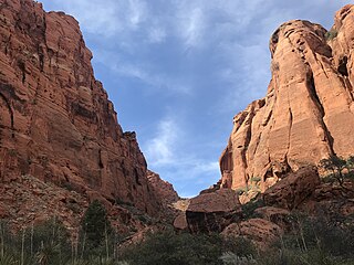
Padre Canyon is adjacent to Snow Canyon State Park and Red Mountain in Ivins, Utah, and features a three sided canyon and scenic sentinels carved from the red Navajo Sandstone. Padre Canyon is part of the Red Cliffs Desert Reserve, a 62,000 acre protected area that contains three distinct ecosystems: the Mojave Desert, the Colorado Plateau and the Great Basin. Geological features of the canyon include Padre Rock, the Padre Arch, pillared rock formations and sand dunes.

Aztec Butte Rock formation in Utah, United States

Aztec Butte is a sandstone summit, elevation 6,312 feet, located in the Island in the Sky District of Canyonlands National Park, in San Juan County, Utah. Aztec Butte is composed of white cross-bedded Navajo Sandstone, which is the remains of wind-borne sand dunes deposited approximately 170 million years ago during the Jurassic Period. It resembles the Pyramid of the Sun in Mexico, which was built by the Aztecs.

References

  1. 1 2 3 4 "Snow Canyon State Park: About the Park". Utah State Parks. Archived from the original on 2011-03-16. Retrieved 2011-02-11.
  2. "Utah State Park 2011 Visitation" (PDF). Utah State Parks Planning. Retrieved 28 May 2012.
  3. "Map of Generalized Geology of Snow Canyon State Park" (PDF). Utah Geological Survey. Retrieved 25 January 2021.
  4. "Snow Canyon State Park". stateparks.utah.gov. Utah Division of State Parks and Recreation.
  5. "Book a Campsite at Snow Canyon State Park, UT". utahstateparks.reserveamerica.com. Utah Division of State Parks and Recreation.
  6. "Snow Canyon State Park:Park Fees". stateparks.utah.gov. Utah Division of State Parks and Recreation.
  7. "Snow Canyon State Park entrance fees to go up". www.stgeorgeutah.com. St. George News.
  8. "Johnson's Canyon Trail Guide" (PDF). Utah Division of State Parks and Recreation. Retrieved 12 January 2021.
  9. 1 2 "Snow Canyon day; a breathtaking land of stark contrasts" . Retrieved 2021-01-26.
  10. "Weather averages Ivins, Utah". www.usclimatedata.com. Retrieved 2021-01-27.
  11. 1 2 3 4 "Snow Canyon State Park, Utah". wchsutah.org. Retrieved 2021-01-26.
  12. "Celebrating 50 years of Utah State Parks". The Salt Lake Tribune. Retrieved 2021-01-26.
  13. Maddrey, Joseph (2016). The Quick, the Dead and the Revived: The Many Lives of the Western Film. McFarland. Page 178. ISBN   9781476625492.
  14. 1 2 3 "Discover". Utah State Parks. Retrieved 2022-05-23.
  15. "Bobcat found on Snow Canyon Parkway" . Retrieved 2022-05-23.
  16. "Critters". Friends of Snow Canyon. Retrieved 2022-05-23.
  17. "Snow Canyon State Park: Hidden Pinyon Trail Guide" (PDF). Hidden Pinyon Trail Guide. Retrieved May 23, 2022.