
Garfield County is a county in south central Utah, United States. As of the 2010 United States Census the population was 5,172, making it the fifth-least populous county in Utah; with about 0.98 inhabitants per square mile, it is also the least densely populated county in Utah. Its county seat and largest city is Panguitch.

Millard County is a county in the U.S. state of Utah. As of the 2010 United States Census, the population was 12,503. Its county seat is Fillmore, and the largest city is Delta.
Piute County is a county in south-central Utah, United States. As of the 2010 United States Census, the population was 1,556, making it the second-least populous county in Utah. The county seat is Junction, and the largest town is Circleville.

Summit County is a county in the U.S. state of Utah, occupying a rugged and mountainous area. As of the 2010 United States Census, the population was 36,324. Its county seat is Coalville, and the largest city is Park City.

Sanpete County is a county in the U.S. state of Utah. As of the 2010 United States Census, the population was 27,822. Its county seat is Manti, and its largest city is Ephraim. The county was created in 1850.

Sevier County is a county in Utah, United States. As of the 2010 United States Census, the population was 20,802. Its county seat and largest city is Richfield.

Uintah County is a county in the U.S. state of Utah. As of the 2010 United States Census the population was 32,588. Its county seat and largest city is Vernal. The county was named for the portion of the Ute Indian tribe that lived in the basin.

Wayne County is a county in the U.S. state of Utah. As of the 2010 census, the population was 2,778, making it the fourth-least populous county in Utah. Its county seat is Loa.

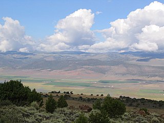
Koosharem is a town in Sevier County, Utah, United States. Koosharem is also known as "Grass Valley". It generally comprises the area known as Burrville, Utah on the north, south through the valley and through the town of Koosharem and down to the south end with the town of Greenwich, Utah. The valley is made up of private lands nestled within the Fishlake National Forest. Koosharem is situated at the cross-roads for travelers going between Capitol Reef National Park and Bryce Canyon National Park and/or Zion National Park. Koosharem is also the closest town to the famous Fish Lake. The town also serves as an important point along the many trails of the Piute ATV Trail System.

The Sevier River is a 400-mile (640 km)-long river in the Great Basin of southwestern Utah in the United States. Originating west of Bryce Canyon National Park, the river flows north through a chain of high farming valleys and steep canyons along the west side of the Sevier Plateau, before turning southwest and terminating in the endorheic basin of Sevier Lake in the Sevier Desert. It is used extensively for irrigation along its course, with the consequence that Sevier Lake is usually dry.

Flaming Gorge Dam is a concrete thin-arch dam on the Green River, a major tributary of the Colorado River, in northern Utah in the United States. Flaming Gorge Dam forms the Flaming Gorge Reservoir, which extends 91 miles (146 km) into southern Wyoming, submerging four distinct gorges of the Green River. The dam is a major component of the Colorado River Storage Project, which stores and distributes upper Colorado River Basin water.
The Provo River is located in Utah County and Wasatch County, Utah, in the United States. It rises in the Uinta Mountains at Wall Lake and flows about 71 miles (114 km) southwest to Utah Lake at the city of Provo, Utah.

Fred Hayes State Park at Starvation is a state park in northeastern Utah, United States, featuring the 3,495-acre (1,414 ha) Starvation Reservoir. The park is 4 miles (6.4 km) northwest of the town of Duchesne, Utah.

Hyrum State Park is a state park and reservoir in Cache County, Utah, United States.

Huntington State Park is a protected area of Utah, United States, featuring a warm-water reservoir. The state park is located near the town of Huntington.
Millsite State Park is a state park on the south end of Millsite Reservoir at the mouth of Ferron Canyon in western Emery County, Utah, United States, just west of the town of Ferron.
Yuba State Park is a state park on the Sevier Bridge Reservoir in Juab and Sanpete counties in central Utah, United States.

Gunlock State Park is a state park of Utah, USA, adjoining a 266-acre (108 ha) reservoir. The park is located approximately 15 miles (24 km) northwest of St George. The reservoir dam was constructed in 1970 for irrigation water and flood control.

Quail Creek State Park is a state park of Utah, United States, featuring a 600-acre (240 ha) reservoir. The park is located within Hurricane, Utah, 9 miles (14 km) west of the city center and 1.5 miles (2.4 km) south of the historic ghost town of Harrisburg. Quail Creek State Park offers camping, boating, swimming, and fishing.
The Mormon Pioneer National Heritage Area (MPNHA) is a federally designated National Heritage Area that recognizes and commemorates the efforts of Mormon pioneers who made the trek westward, settling Utah and the American West. Spanning a 400-mile area along U.S. Highway 89, Utah State Route 24 and Utah State Route 12 – an All American Road – the MPNHA encompasses five unique districts, each with its own distinct history and landmarks.


