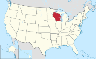
Douglas County is a county located at the northwest corner of the U.S. state of Wisconsin. As of the 2010 census, the population was 44,159. Its county seat is Superior.

Sheldon is a town in Wyoming County, New York. The population was 2,409 at the 2010 census. The Town of Sheldon is on the west border of Wyoming County. The town is southeast of Buffalo.

Portage is a city in and the county seat of Columbia County, Wisconsin, United States. The population was 10,662 at the 2010 census making it the largest city in Columbia County. The city is part of the Madison Metropolitan Statistical Area.

Watertown is a city in Dodge and Jefferson counties in the U.S. state of Wisconsin. Most of the city's population is in Jefferson County. Division Street, several blocks north of downtown, marks the county line. The population of Watertown was 23,861 at the 2010 census. Of this, 15,402 were in Jefferson County, and 8,459 were in Dodge County.

Douglas is a town in Marquette County, Wisconsin, United States. The population was 768 at the 2000 census. The unincorporated communities of Briggsville and Douglas Center are located within the town.

Elkhorn is a city in Walworth County, Wisconsin, United States. It is located 40 miles (64 km) southwest of Milwaukee. The population was 10,084 at the 2010 census. It is the county seat.
Beaver Dam is a city in Dodge County, Wisconsin, United States, along Beaver Dam Lake and the Beaver Dam River. The estimated population was 16,564 in 2016, making it the largest city primarily located in Dodge County. It is the principal city of the Beaver Dam Micropolitan Statistical area. The city is adjacent to the Town of Beaver Dam.

Viroqua is the county seat of Vernon County, Wisconsin, United States. The population was 4,362 at the 2010 census. The city is in the town of Viroqua.

The Territory of Iowa was an organized incorporated territory of the United States that existed from July 4, 1838, until December 28, 1846, when the southeastern portion of the territory was admitted to the Union as the state of Iowa. The remainder of the territory would have no organized territorial government until the Minnesota Territory was organized on March 3, 1849.
U.S. Highway 8 (US 8) is a United States Numbered Highway that runs primarily east–west for 280 miles (451 km), mostly within the state of Wisconsin. It connects Interstate 35 (I-35) in Forest Lake, Minnesota, to US 2 at Norway in the Upper Peninsula of Michigan near the border with Wisconsin. Except for the short freeway segment near Forest Lake, and sections near the St. Croix River bridge and Rhinelander, Wisconsin, it is mostly undivided surface road. As a state highway in the three states, US 8 is maintained by the Minnesota, Wisconsin and Michigan departments of transportation.

The Manual on Uniform Traffic Control Devices (MUTCD) is a document issued by the Federal Highway Administration (FHWA) of the United States Department of Transportation (USDOT) to specify the standards by which traffic signs, road surface markings, and signals are designed, installed, and used. These specifications include the shapes, colors, and fonts used in road markings and signs. In the United States, all traffic control devices must legally conform to these standards. The manual is used by state and local agencies as well as private construction firms to ensure that the traffic control devices they use conform to the national standard. While some state agencies have developed their own sets of standards, including their own MUTCDs, these must substantially conform to the federal MUTCD.

A county highway is a road in the United States and in the Canadian province of Ontario that is designated and/or maintained by the county highway department. Route numbering can be determined by each county alone, by mutual agreement among counties, or by a statewide pattern.

South Range is an unincorporated community, located in the town of Parkland, Douglas County, Wisconsin, United States.

Chengwatana is an abandoned village site in Pine County, Minnesota, United States.

Valley Junction is an unincorporated community located in the town of Byron, Monroe County, Wisconsin, United States. It is located at the intersection of Wisconsin Highway 173, County Highway G, and County Highway N.
Robert Mitchell was an American physician and farmer from Douglas Center, Wisconsin who served one term as a Republican member of the Wisconsin State Assembly.
Good Hope was an inhabited place in the Town of Milwaukee in Milwaukee County, Wisconsin, United States.

The Wisconsin State Trunk Highway System is the state highway system of the U.S. state of Wisconsin, including Wisconsin's segments of the Interstate Highway System and the United States Numbered Highway System, in addition to its other state trunk highways. These separate types of highways are respectively designated with an I-, US, or STH- prefix. The system also includes minor roads designated as Scenic Byways, four routes intended to promote tourism to scenic and historic areas of the state; and as Rustic Roads, lightly-traveled and often unpaved local roads which the state has deemed worthy of preservation and protection. The state highway system, altogether totaling 11,753 miles (18,915 km) across all of Wisconsin's 72 counties, is maintained by the Wisconsin Department of Transportation (WisDOT).
Yankeetown is an unincorporated community in the town of Clayton, Crawford County, Wisconsin, United States, approximately two miles southwest of Soldiers Grove, Wisconsin on Wisconsin Highway 131.
Job N. Grant was an American farmer from the Town of Wonewoc, Wisconsin, near Union Center, who held a number of local public offices, and spent a single one-year term as a Reform Party member of the Wisconsin State Assembly from Juneau County.