Moundville, Wisconsin

Last updated

Moundville, Wisconsin
WIMap-doton-Moundville.png
Location of Moundville, Wisconsin
Coordinates: 43°40′29″N89°28′3″W / 43.67472°N 89.46750°W / 43.67472; -89.46750
Country Flag of the United States.svg  United States
State Flag of Wisconsin.svg  Wisconsin
County Marquette
Area
  Total23.2 sq mi (60.1 km2)
  Land22.9 sq mi (59.4 km2)
  Water0.3 sq mi (0.7 km2)
Elevation
[1]
787 ft (240 m)
Population
 (2000)
  Total574
  Density25.0/sq mi (9.7/km2)
Time zone UTC-6 (Central (CST))
  Summer (DST) UTC-5 (CDT)
FIPS code 55-54600 [2]
GNIS feature ID1583759 [1]

Moundville is a town in Marquette County, Wisconsin, United States. The population was 574 at the 2000 census.

Contents

Geography

According to the United States Census Bureau, the town has a total area of 23.2 square miles (60.1 km2), of which, 22.9 square miles (59.4 km2) of it is land and 0.3 square miles (0.7 km2) of it (1.16%) is water.

Demographics

As of the census [2] of 2000, there were 574 people, 209 households, and 159 families residing in the town. The population density was 25.0 people per square mile (9.7/km2). There were 245 housing units at an average density of 10.7 per square mile (4.1/km2). The racial makeup of the town was 96.69% White, 0.35% African American, 0.17% Native American, 0.87% Asian, 1.05% from other races, and 0.87% from two or more races. Hispanic or Latino of any race were 4.18% of the population.

There were 209 households, out of which 35.9% had children under the age of 18 living with them, 63.6% were married couples living together, 6.2% had a female householder with no husband present, and 23.9% were non-families. 18.7% of all households were made up of individuals, and 9.6% had someone living alone who was 65 years of age or older. The average household size was 2.69 and the average family size was 3.03.

In the town, the population was spread out, with 29.1% under the age of 18, 5.7% from 18 to 24, 27.0% from 25 to 44, 22.1% from 45 to 64, and 16.0% who were 65 years of age or older. The median age was 38 years. For every 100 females, there were 100.7 males. For every 100 females age 18 and over, there were 106.6 males.

The median income for a household in the town was $40,893, and the median income for a family was $42,813. Males had a median income of $32,404 versus $23,750 for females. The per capita income for the town was $14,930. About 3.6% of families and 7.1% of the population were below the poverty line, including 6.4% of those under age 18 and 7.1% of those age 65 or over.

See also

Related Research Articles

<span class="mw-page-title-main">Moundville, Alabama</span> Town in Alabama, United States

Moundville is a town in Hale and Tuscaloosa counties in the U.S. state of Alabama. It was incorporated on December 22, 1908. From its incorporation until the 1970 census, it was wholly within Hale County. At the 2010 census the population was 2,427, up from 1,809 at the 2000 census. It is part of the Tuscaloosa Metropolitan Statistical Area. Within the town is Moundville Archaeological Site, the location of a prehistoric Mississippian culture political and ceremonial center.

<span class="mw-page-title-main">Trenton, Maine</span> Town in the state of Maine, United States

Trenton is a town in Hancock County, Maine, United States, near Acadia National Park. The population was 1,584 at the 2020 census. Hancock County-Bar Harbor Airport is located in Trenton.

<span class="mw-page-title-main">Beverly Hills, Missouri</span> City in Missouri, United States

Beverly Hills is a city in St. Louis County, Missouri, United States. As of the 2010 census, the city population was 574.

<span class="mw-page-title-main">Bronaugh, Missouri</span> City in Missouri, United States

Bronaugh is a city in southwest Vernon County, Missouri, United States. The population was 249 at the 2010 census.

<span class="mw-page-title-main">Moundville, Missouri</span> Village in Missouri, United States

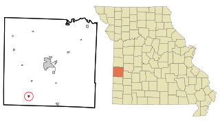
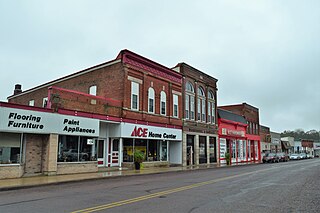
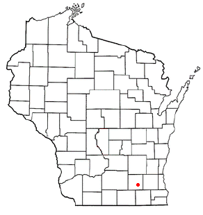
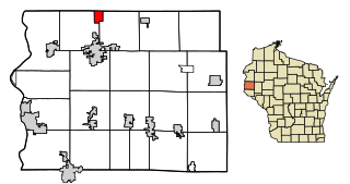
Moundville is a village in southwest Vernon County, Missouri, United States. The population was 124 at the 2010 census.

<span class="mw-page-title-main">Neosho, Wisconsin</span> Village in Wisconsin, United States

Neosho is a village in Dodge County, Wisconsin, United States. The population was 574 at the 2010 census.

<span class="mw-page-title-main">Tainter, Wisconsin</span> Town in Wisconsin, United States

The Town of Tainter is a town in Dunn County, Wisconsin, United States. The population was 2,116 at the 2000 census. Part of the census-designated place of Tainter Lake is located in the town. The unincorporated community of Norton is also located in the town.

Rome is a census-designated place (CDP) in the town of Sullivan in Jefferson County, Wisconsin, United States, along the Bark River. The population was 752 at the 2020 census.

<span class="mw-page-title-main">Green Valley, Marathon County, Wisconsin</span> Town in Wisconsin, United States

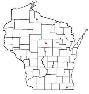
Green Valley is a town in Marathon County, Wisconsin, United States. It is part of the Wausau, Wisconsin Metropolitan Statistical Area. The population was 541 at the 2010 census. The unincorporated community of Rangeline is located partially in the town.

<span class="mw-page-title-main">Hatley, Wisconsin</span> Village in Wisconsin, United States

Hatley is a village in Marathon County, Wisconsin, United States. It is part of the Wausau, Wisconsin Metropolitan Statistical Area. The population was 574 at the 2010 census.

<span class="mw-page-title-main">Marathon, Wisconsin</span> Town in Wisconsin, United States

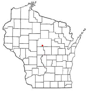
Marathon is a town in Marathon County, Wisconsin, United States. It is part of the Wausau, Wisconsin Metropolitan Statistical Area. The population was 1,048 at the 2010 census. The village of Marathon City was incorporated from a part of the town's original area.

<span class="mw-page-title-main">Dewey, Rusk County, Wisconsin</span> Town in Wisconsin, United States

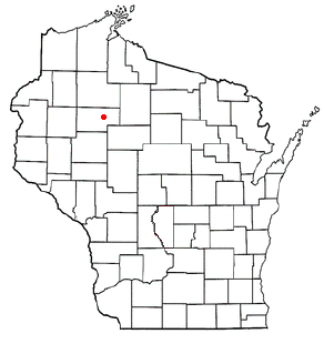
Dewey is a town in Rusk County, Wisconsin, United States. As of the 2000 census, the town had a total population of 523.

<span class="mw-page-title-main">Herman, Sheboygan County, Wisconsin</span> Town in Wisconsin, United States

Herman is a town in Sheboygan County, Wisconsin, United States. The population was 2,044 at the 2000 census. It is included in the Sheboygan, Wisconsin Metropolitan Statistical Area. The town is home to Lakeland University.

<span class="mw-page-title-main">Bloomington, Wisconsin</span> Village in Wisconsin, United States

Bloomington is a village in Grant County, Wisconsin, United States. The population was 735 as of the 2010 census. The village is located within the Town of Bloomington.

<span class="mw-page-title-main">Hebron (CDP), Wisconsin</span> Census-designated place in Wisconsin, United States

Hebron is a census-designated place (CDP) in the town of Hebron, Jefferson County, Wisconsin, United States. The population was 209 at the 2020 census. It is located on the Bark River.

Luck is a town in Polk County, Wisconsin, United States. The population was 881 at the 2000 census. The village of Luck is located within the town. The unincorporated community of West Denmark is located in the town. The unincorporated community of Pole Cat Crossing is also located partially in the town.

Almond is a town in Portage County, Wisconsin, United States. The population was 679 at the 2000 census. The unincorporated community of West Almond is located in the town.

Ironton is a town in Sauk County, Wisconsin, United States. The population was 650 at the 2000 census. The town was named from deposits of iron ore in the area. The Village of Ironton is located within the town.

<span class="mw-page-title-main">Star Prairie, Wisconsin</span> Village in Wisconsin, United States

Star Prairie is a village in St. Croix County in the U.S. state of Wisconsin. The population was 561 at the 2010 census. The village is located along the Apple River on the boundary between the Town of Star Prairie and the Town of Stanton.

<span class="mw-page-title-main">Wautoma (town), Wisconsin</span> Town in Wisconsin, United States

Wautoma is a town in Waushara County, Wisconsin, United States. The population was 1,312 at the 2000 census.

References

  1. 1 2 "US Board on Geographic Names". United States Geological Survey. October 25, 2007. Retrieved January 31, 2008.
  2. 1 2 "U.S. Census website". United States Census Bureau . Retrieved January 31, 2008.

Commons-logo.svg Media related to Moundville, Wisconsin at Wikimedia Commons