Mecan, Wisconsin

Last updated

Mecan, Wisconsin
WIMap-doton-Mecan.png
Location of Mecan, Wisconsin
Coordinates: 43°48′12″N89°13′1″W / 43.80333°N 89.21694°W / 43.80333; -89.21694
Country Flag of the United States.svg  United States
State Flag of Wisconsin.svg  Wisconsin
County Marquette
Area
  Total27.5 sq mi (71.3 km2)
  Land27.5 sq mi (71.1 km2)
  Water0.1 sq mi (0.2 km2)
Elevation
[1]
778 ft (237 m)
Population
 (2000)
  Total726
  Density26.4/sq mi (10.2/km2)
Time zone UTC-6 (Central (CST))
  Summer (DST) UTC-5 (CDT)
FIPS code 55-50350 [2]
GNIS feature ID1583681 [1]
Website http://www.townofmecan.org/

Mecan is a town in Marquette County, Wisconsin, United States. The population was 726 at the 2000 census. The unincorporated community of Mecan is located in the town.

Contents

Geography

According to the United States Census Bureau, the town has a total area of 27.5 square miles (71.3 km2), of which, 27.5 square miles (71.1 km2) of it is land and 0.1 square miles (0.2 km2) of it (0.29%) is water.

History

Name

The name of the town is after Mecan River, which is a corruption of "Namayicun", from one of the Algonquian languages meaning "Sturgeoning Grounds" (c.f. Ojibwe language: namekaan, "sturgeoning grounds"). However, Vogel (1991) cites the name to come from the Ojibwe word miikana meaning "road." [3]

Demographics

As of the census [2] of 2000, there were 726 people, 321 households, and 217 families residing in the town. The population density was 26.4 people per square mile (10.2/km2). There were 735 housing units at an average density of 26.8 per square mile (10.3/km2). The racial makeup of the town was 97.11% White, 0.69% African American, 0.14% Native American, 0.41% Asian, 0.69% from other races, and 0.96% from two or more races. Hispanic or Latino of any race were 1.52% of the population.

There were 321 households, out of which 19.9% had children under the age of 18 living with them, 61.1% were married couples living together, 4.0% had a female householder with no husband present, and 32.1% were non-families. 25.9% of all households were made up of individuals, and 15.3% had someone living alone who was 65 years of age or older. The average household size was 2.26 and the average family size was 2.72.

In the town, the population was spread out, with 17.1% under the age of 18, 5.6% from 18 to 24, 21.6% from 25 to 44, 29.2% from 45 to 64, and 26.4% who were 65 years of age or older. The median age was 47 years. For every 100 females, there were 105.1 males. For every 100 females age 18 and over, there were 102.0 males.

The median income for a household in the town was $31,389, and the median income for a family was $34,519. Males had a median income of $32,778 versus $17,656 for females. The per capita income for the town was $16,464. About 3.8% of families and 5.7% of the population were below the poverty line, including none of those under age 18 and 13.5% of those age 65 or over.

Related Research Articles

<span class="mw-page-title-main">Marquette County, Wisconsin</span> County in Wisconsin, United States

Marquette County is a county located in the U.S. state of Wisconsin. As of the 2020 census, the population was 15,592. Its county seat is Montello. The county was created in 1836 from the Wisconsin Territory and organized in 1848.

<span class="mw-page-title-main">Sylvania, Alabama</span> Town in Alabama, United States

Sylvania is a town in DeKalb County, Alabama, United States. It incorporated in October 1967. At the 2010 census the population was 1,837, up from 1,186 in 2000. Sylvania is located atop Sand Mountain. Sylvania was incorporated in 1967. The post office /town hall was built in 1977.

<span class="mw-page-title-main">German Valley, Illinois</span> Village in Illinois, United States

German Valley is a village in Stephenson County, Illinois, United States. German Valley is located four miles south of U.S. Route 20 between Freeport and Rockford. German Valley had a population of 433 at the 2020 census, with a 2023 estimate of 424.

<span class="mw-page-title-main">Albion, Dane County, Wisconsin</span> Town in Wisconsin, United States

The Town of Albion is located in Dane County, Wisconsin, United States. The population was 2,069 at the 2020 Census. The unincorporated communities of Albion, Highwood, Hillside, and Indian Heights are located in the town.

<span class="mw-page-title-main">Ashippun, Wisconsin</span> Town in Wisconsin, United States

Ashippun is a town in Dodge County, Wisconsin, United States. The unincorporated communities of Alderley, Ashippun, and Old Ashippun are located in the town. The population was 2,308 at the 2000 census.

<span class="mw-page-title-main">Amnicon, Wisconsin</span> Town in Wisconsin, United States

Amnicon is a town in Douglas County, Wisconsin, United States. The population was 1,155 at the 2010 census. The unincorporated communities of Amnicon Falls, Middle River, Rockmont and Wentworth are located in the town.

<span class="mw-page-title-main">Norrie, Wisconsin</span> Town in Wisconsin, United States

The Town of Norrie is located in Marathon County, Wisconsin, United States. It is part of the Wausau, Wisconsin Metropolitan Statistical Area. The population was 976 at the 2010 census.

<span class="mw-page-title-main">Packwaukee, Wisconsin</span> Town in Wisconsin, United States

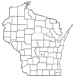
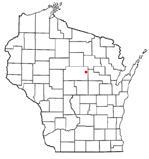
Packwaukee is a town in Marquette County, Wisconsin, United States. The population was 2,574 at the 2000 census. The unincorporated communities of Buffalo Shore Estates and Packwaukee are located in the town.

<span class="mw-page-title-main">Lake Tomahawk, Wisconsin</span> Town in Wisconsin, United States

Lake Tomahawk is a town in Oneida County, Wisconsin, United States named for the adjacent freshwater lake of the same name. The population was 1,160 at the 2000 census. The census-designated place of Lake Tomahawk and the unincorporated community of Sunflower are located in the town.

Woodruff is a town in Oneida County, Wisconsin, United States. The population was 2,055 at the 2010 census. The census-designated place of Woodruff is located in the town.

<span class="mw-page-title-main">Grant, Portage County, Wisconsin</span> Town in Wisconsin, United States

Grant is a town in Portage County, Wisconsin, United States. The population was 2,020 at the 2000 census. The unincorporated community of Kellner is located partially in the town.

<span class="mw-page-title-main">Dane (town), Wisconsin</span>

Dane is a town in Dane County, Wisconsin, United States. The population was 968 at the 2000 census. The unincorporated community of Lutheran Hill is located partially in the town.

<span class="mw-page-title-main">Deerfield, Wisconsin</span> City in Wisconsin, United States

Deerfield is a city in Dane County, Wisconsin. The population was 2,319 at the time of the 2010 census. The city is located within the Town of Deerfield. It is part of the Madison Metropolitan Statistical Area. Towns and villages near Deerfield include Marshall, Medina, London, Cambridge, and Cottage Grove, Wisconsin.

<span class="mw-page-title-main">Mazomanie (town), Wisconsin</span>

Mazomanie is a town in Dane County, Wisconsin. The population was 1,185 at the time of the 2000 census. The Village of Mazomanie is located within the town.

<span class="mw-page-title-main">Sturgeon Bay (town), Wisconsin</span> Town in Wisconsin, United States

Sturgeon Bay is a town in Door County, Wisconsin, USA. The population was 865 at the 2000 census.

<span class="mw-page-title-main">Mosinee, Wisconsin</span> City in Wisconsin, United States

Mosinee is a city in Marathon County, Wisconsin. It is part of the Wausau, Wisconsin Metropolitan Statistical Area. The population was 4,452 at the time of the 2020 census.

Merrimac is a town in Sauk County, Wisconsin, United States. The population was 868 at the 2000 census. The Village of Merrimac is located within the town. The unincorporated community of Moon Valley is located in the town. The census-designated place of Lake Wisconsin is also located partially in the town.

<span class="mw-page-title-main">Aniwa, Wisconsin</span> Village in Wisconsin, United States

Aniwa is a village in Shawano County, Wisconsin, United States. The population was 260 at the 2010 census. The village is located within the Town of Aniwa. U.S. Route 45 runs north–south through the village.

<span class="mw-page-title-main">Minong, Wisconsin</span> Village in Wisconsin, United States

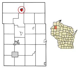
Minong is a village in Washburn County, Wisconsin, United States. The population was 548 at the 2020 census. The village is located within the Town of Minong.

<span class="mw-page-title-main">Pewaukee (village), Wisconsin</span> Village in Wisconsin, United States

Pewaukee is a village in Waukesha County, Wisconsin, United States. The population was 8,238 at the 2020 census. The village is nearly surrounded by the City of Pewaukee. The village was incorporated from what was formerly the Town of Pewaukee, and the remainder of the town later incorporated as a city.

References

  1. 1 2 "US Board on Geographic Names". United States Geological Survey. October 25, 2007. Retrieved January 31, 2008.
  2. 1 2 "U.S. Census website". United States Census Bureau . Retrieved January 31, 2008.
  3. 'Indian Names on Wisconsin's Maps,' Virgil J. Vogel, University of Wisconsin Press, Madison, Wisconsin: 1991, pg. 127

43°47′46″N89°12′54″W / 43.79611°N 89.21500°W / 43.79611; -89.21500