
Lecanto is an unincorporated community and census-designated place (CDP) in Citrus County, Florida, United States. As of the 2010 census it had a population of 5,882, up from 5,161 in 2000. It is home to several county government facilities such as the Citrus County Sheriff's Office and the Citrus Campus of the College of Central Florida.

South Brooksville is a census-designated place (CDP) in Hernando County, Florida, United States. The population was 4,007 at the 2010 census. It is a suburb included in the Tampa-St. Petersburg-Clearwater, Florida Metropolitan Statistical Area.

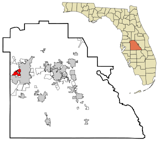
Mango is a census-designated place (CDP) in Hillsborough County, Florida, United States. The population was 12,699 at 2020 census, up from the 11,313 at the 2010 census.

Bokeelia is an unincorporated community and census-designated place (CDP) located on Pine Island in Lee County, Florida, United States. As of the 2020 census, the CDP had a population of 1,855, up from 1,780 at the 2010 census. It is part of the Cape Coral-Fort Myers, Florida Metropolitan Statistical Area. Bokeelia is still home to one of Lee County's first pioneer families, the Padillas, who came by way of Cayo Costa.

Pine Island Center is an unincorporated community and census-designated place (CDP) located on Pine Island in Lee County, Florida, United States. The population was 1,942 at the 2020 census, up from 1,854 at the 2010 census. It is part of the Cape Coral-Fort Myers, Florida Metropolitan Statistical Area.

Pineland is an unincorporated community and census-designated place (CDP) on Pine Island in Lee County, Florida, United States. The population was 466 at the 2020 census, up from 407 at the 2010 census. It is part of the Cape Coral-Fort Myers, Florida Metropolitan Statistical Area.

Andrews is a census-designated place (CDP) in Levy County, Florida, United States. The population was 837 at the 2020 census, up from 798 at the 2010 census. It is part of the Gainesville, Florida Metropolitan Statistical Area.

Bronson is a town and the county seat of Levy County, Florida, United States. The population was 1,140 at the 2020 census, up from 1,113 at the 2010 census. It is part of the Gainesville, Florida Metropolitan Statistical Area.

Manatee Road is a census-designated place (CDP) in Levy County, Florida, United States. The population was 2,484 at the 2020 census, up from 2,244 at the 2010 census. At the 2000 census, the CDP was misspelled as "Manattee Road". It is part of the Gainesville, Florida Metropolitan Statistical Area.

West Bradenton is an unincorporated area and census-designated place (CDP) in Manatee County, Florida, United States. The population was 4,247 at the 2020 census, up from 4,192 at the 2010 census. It is part of the North Port–Bradenton–Sarasota, Florida Metropolitan Statistical Area.

Palmetto Estates is an unincorporated area and census-designated place (CDP) in Miami-Dade County, Florida, United States. It is part of the Miami metropolitan area of South Florida. The population was 13,498 at the 2020 census.

Dade City North is a census-designated place (CDP) in eastern Pasco County, Florida, United States. The population was 3,319 at the 2000 census.

Trinity is a census-designated place (CDP) in Pasco County, Florida, United States. The population was 10,907 in 2010, according to the most recent census. The Trinity Community is named after Trinity College of Florida, a Bible college founded in 1932, when it relocated to the first occupied site in the communities developed by James Gills in the late 1980s. The main plaza is found near the high school, known as Mitchell Ranch Plaza. Trinity is located at the junction where Pasco, Hillsborough and Pinellas Counties meet. The community of Longleaf is located in Trinity and it is believed that the “Welcome Plank” originated in Longleaf.

Feather Sound is a census-designated place (CDP) in Pinellas County, Florida, United States. The population was 3,420 at the 2010 census. It includes the St. Petersburg-Clearwater International Airport.
Winston is a former census-designated place (CDP) in Polk County, Florida, United States. The population was 9,024 at the 2000 census. Most of the community's core is now part of neighboring Lakeland. It is part of the Lakeland–Winter Haven Metropolitan Statistical Area.

North Sarasota is a census-designated place (CDP) in Sarasota County, Florida, United States. The population was 2,418 at the 2020 census, down from 6,982 at the 2010 census. It is part of the North Port–Bradenton–Sarasota, Florida Metropolitan Statistical Area.

Samsula-Spruce Creek is a census-designated place (CDP) in Volusia County, Florida, United States. The population was 5,047 at the 2010 census. While many households reside here, it is principally an agricultural area west of the cities of Port Orange and New Smyrna Beach.

Carrollwood is a census-designated place (CDP) in northwestern Hillsborough County, Florida, United States. The census area includes the unincorporated communities of Carrollwood and Carrollwood Village. For the 2000 census the area was enumerated under the name "Greater Carrollwood". A similar area was listed as "Lake Carroll" in 1970 and 1980; for the 1990 census it was split into the smaller Carrollwood and Carrollwood Village CDPs. The population was 34,352 at the 2020 census.

Williston Highlands is a census-designated place (CDP) in Levy County, Florida, United States. The population was 2,591 at the 2020 census, up from 2,275 at the 2010 census. It is part of the Gainesville, Florida Metropolitan Statistical Area.

Terrace Heights is a census-designated place (CDP) in Yakima County, Washington, United States. The population was 9,244 at the 2020 census. It is essentially a suburb of the city of Yakima.

