
Shelby Charter Township, officially the Charter Township of Shelby, is a charter township located in Macomb County in the U.S. state of Michigan. The township, an affluent northern suburb of Detroit, is located roughly 15 miles (24 km) north of the city. The 2020 Census places the population at 79,408. Shelby Charter Township is one of the fastest-growing communities in Metro Detroit.
Solebury Township is a township in Bucks County, Pennsylvania, United States. The population was 8,709 at the 2020 census.

Buckingham is a second-class township in Wayne County, Pennsylvania, United States. The township's population was 520 at the time of the 2010 United States Census.

Cambridge is a city in the Regional Municipality of Waterloo, Ontario, Canada, located at the confluence of the Grand and Speed rivers. The city had a population of 138,479 as of the 2021 census. Along with Kitchener and Waterloo, Cambridge is one of the three core cities of Canada's tenth-largest metropolitan area.
Taylorstown is a small community in Loudoun County, Virginia, built on the banks of Catoctin Creek and the surrounding hillside, about two miles (3 km) south of the Potomac River. First settled in 1734, it holds two of the oldest standing houses in Loudoun County, "Hunting Hill" and "Foxton Cottage", directly across the Catoctin Creek from each other.

Larrys Creek is a 22.9-mile-long (36.9 km) tributary of the West Branch Susquehanna River in Lycoming County in the U.S. state of Pennsylvania. A part of the Chesapeake Bay drainage basin, its watershed drains 89.1 square miles (231 km2) in six townships and a borough. The creek flows south from the dissected Allegheny Plateau to the Ridge-and-valley Appalachians through sandstone, limestone, and shale from the Devonian, Mississippian, and Pennsylvanian periods.

Delta, Ontario, is a community in the Township of Rideau Lakes, Leeds and Grenville County in Eastern Ontario. The village is located between two lakes, Upper Beverley and Lower Beverley, along highway 42, approximately 15 kilometres west of Athens, Ontario and 28 kilometres east of Westport, Ontario.

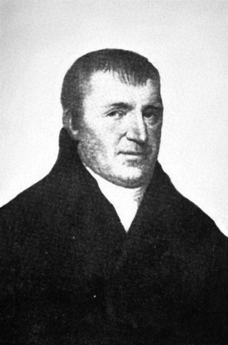
Benjamin Bussey (1757—1842) was a prosperous merchant, farmer, horticulturalist and patriot in Boston, Massachusetts, United States, who made significant contributions to the creation of the Arnold Arboretum. He was said to be "a man of excellent business capacity."
Swiss is an unincorporated community in western Nicholas County, West Virginia, United States. Its elevation is 735 ft (224 m).
Charles Mears was a Michigan lumber businessman, capitalist, merchant, transportation executive, engineer, and farmer. He owned thousands of acres of timber in Michigan, and had 15 sawmills to produce lumber. Mears built cargo boats to transport his lumber to Chicago, and developed several harbors in western Michigan.

Poyntelle is a village in Preston Township, Wayne County, Pennsylvania, United States, in the Lake Region of the Poconos. It was once a depot of the Scranton Division of the New York, Ontario & Western (O&W) Railway, but today, when it is known outside of its immediate vicinity, it is largely for being the location of Camps Westmont and Poyntelle, since the reputation and commercial reach of both, like those of most rural American summer camps, extend beyond the community in which the camps are physically located.
Griffins Mills is a hamlet in the town of Aurora in Erie County, New York, United States. It lies on the West Branch of Cazenovia Creek in the area once known as West Aurora. Griffins Mills was founded in the early 19th century at the site of a mill. It is located in zip code 14170.

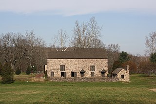
The Newlin Mill Complex, also referred to as The Newlin Grist Mill, is a water-powered gristmill on the west branch of Chester Creek near Concordville, Pennsylvania built in 1704 by Nathaniel and Mary Newlin and operated commercially until 1941. During its three centuries of operation, the mill has been known as the Lower Mill, the Markham Mill, the Seventeen-O-Four Mill and the Concord Flour Mill. In 1958 the mill property was bought by E. Mortimer Newlin, restored and given to the Nicholas Newlin Foundation to use as a historical park. Water power is still used to grind corn meal which is sold on site. The park includes five historical buildings, which were added to the National Register of Historic Places in 1983, and 150 acres (61 ha) of natural woodland.
The Bloomvale Historic District is located east of the hamlet of Salt Point, New York, United States. It is a collection of buildings and structures around the intersection of Clinton Corners Road, state highway NY 82 and the East Branch of Wappinger Creek. Most of it is in the Town of Pleasant Valley; the eastern portion is in the Town of Washington.
Saugerties is a town in the northeastern corner of Ulster County, New York. The population was 19,038 at the time of the 2020 Census, a decline from 19,482 in 2010. The village of the same name is located entirely within the town.

Henry Ford's Village Industries were small factories located in rural areas of Michigan. Ford developed his Village Industries in part to provide farm workers a stable source of income during the winter months.

Kaiser is a ghost town in Price County, Wisconsin, United States. Kaiser was located in the town of Lake along the current route of the Tuscobia State Trail, 5 miles (8.0 km) west-southwest of Park Falls. The town was marked on USGS maps as late as 1941.
Martin Creek, known locally as Dennis Martin Creek, is a 1.4-mile-long (2.3 km) north by northeastward-flowing stream originating just east of Skyline Boulevard in the Santa Cruz Mountains, near the community of Skylonda in San Mateo County, California. It flows through the town of Woodside before joining Sausal Creek on Stanford University lands just across the border from Woodside. Sausal Creek enters Searsville Reservoir, which flows to San Francisco Bay via San Francisquito Creek.

Doon is a suburban community and former village which is now a part of the city of Kitchener, Ontario, Canada. Doon was settled around 1800 by German Mennonites from Pennsylvania, and after 1830 by Scottish immigrants. The area is located at the confluence of Schneider Creek and the Grand River. The post office was opened in 1845. A large flour mill, oatmeal mill, distillery and sawmill were built on the Doon River over the following years. The Perine brothers established extensive linen works and flax mills near the settlement. By 1870, there was a single church, Presbyterian, a variety of tradesmen and a population of 200.
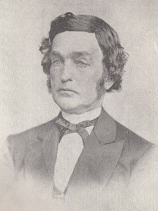
Jedediah Sanger was the founder of the town of New Hartford, New York, United States. He was a native of Sherborn, Massachusetts, and the ninth child of Richard and Deborah Sanger, a prominent colonial New England family. During the Revolutionary War he attained the rank of 1st Lieutenant having fought in the Battles of Lexington and Concord, the Battle of Bunker Hill, the Siege of Boston (1776), and during the New York Campaign.


