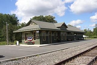
Dreher is a second-class township in Wayne County, Pennsylvania, United States. The township's population was 1,412 at the time of the 2010 United States Census.

Sterling is a second-class township in Wayne County, Pennsylvania. The township's population was 1,450 at the time of the 2010 United States Census.

Newfoundland is a village in Dreher Township, Wayne County, Pennsylvania, United States. It is most famously known as host to the Greene-Dreher-Sterling Fair every Labor Day weekend.
Buffalo is an unincorporated community and census-designated place in eastern Valley Township, Guernsey County, Ohio, United States. As of the 2020 census it had a population of 373. It has a post office with the ZIP code 43722. It lies along State Route 313.

Gouldsboro is a village and census-designated place (CDP) in Lehigh Township in Wayne County, and Coolbaugh Township, in Monroe County, Pennsylvania, United States. The CDP's population was 750 at time of the 2020 United States Census.

Poyntelle is a village that is located in Preston Township, Wayne County, Pennsylvania, United States, in the Lake Region of the Poconos.

Milanville is a village in Damascus Township, Wayne County, Pennsylvania, United States.
Chinchilla is a village and census-designated place in Scott and South Abington townships, Lackawanna County, Pennsylvania, United States. The CDP's population was 2,098 at the time of the 2010 United States Census. It was known as "Leach's Flats" until supposedly renamed by a female postmaster in the 1880 after her chinchilla-fur shawl. Chinchilla is located in the gorge of Leggetts Creek, which flows southward into the Lackawanna River on the north side of Scranton. Interstate 81, U.S. Route 6/11 and the Norfolk Southern Railroad use the gorge between Scranton and Clarks Summit. Chinchilla has its own post office, with ZIP Code 18410.
Concord is an unincorporated community in Fannett Township, Franklin County, Pennsylvania, United States. The community is located on Pennsylvania Route 75, 9.6 miles (15.4 km) south-southwest of East Waterford. Concord has a post office, with ZIP code 17217.

Fannettsburg is an unincorporated town that is located in Metal Township, Franklin County, Pennsylvania, United States.

Pocono Springs is a private community and census-designated place (CDP) in Lehigh and Sterling Townships in Wayne County, Pennsylvania, United States. The CDP's population was 926 at the time of the 2010 United States Census.

Oley, also called Friedensburg, is a census-designated place (CDP) that is located on Routes 73 and 662 in northern Oley Township, Berks County, United States.

Wallenpaupack Lake Estates is a private community and census-designated place in Paupack Township, Wayne County in the U.S. State of Pennsylvania. The community's population was 1,279 as of the 2010 United States Census.
Maxatawny is an unincorporated community located on U.S. Route 222 in Maxatawny Township, Berks County, Pennsylvania, United States, five miles east of Kutztown. It is in the Lehigh watershed and Schaefer Run flows through it to the Little Lehigh Creek. Maxatawny has a post office, with the ZIP code of 19538. Traffic speed on US 222 is reduced to 35 miles-per-hour passing through the village, which borders Lehigh County.

Lakewood is a village that is located in Preston Township, Wayne County, Pennsylvania, United States. It is situated on Pennsylvania Route 370 (PA-370), approximately 7 miles (11 km) east of Thompson, Pennsylvania and about 10 miles (16 km) southwest of Hancock, New York.

Damascus is a village in Damascus Township, Wayne County, Pennsylvania, United States. The Damascus-Cochecton Bridge connects the town with Cochecton, New York across the Delaware River. The bridge is often used by smugglers of fireworks, legal in Pennsylvania but illegal in New York State, in the run-up to the Independence Day holiday, in which observance fireworks are used extensively.

Pleasant Hall is an unincorporated community in Letterkenny Township in Franklin County, Pennsylvania, United States. Pleasant Hall is located at the intersection of state routes 533 and 997, north of Chambersburg and northeast of the Letterkenny Army Depot.

Upper Strasburg is an unincorporated community that is located in Letterkenny Township in Franklin County, Pennsylvania, United States.

Pleasant Mount is an unincorporated community in Mount Pleasant Township, Wayne County, Pennsylvania, United States.
Quincy is an unincorporated community in Quincy Township in southeastern Franklin County, in the U.S. state of Pennsylvania.


