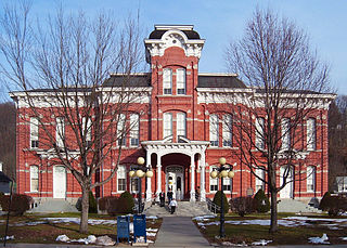
Wayne is a sixth-class county in Pennsylvania. The county's population was 52,822 at the time of the 2010 census. The county seat is the Borough of Honesdale. The county was formed from part of Northampton County on March 21, 1798, and was named for the Revolutionary War General Anthony Wayne.

Dreher is a second-class township in Wayne County, Pennsylvania. The township's population was 1,412 at the time of the 2010 United States Census.

Sterling is a second-class township in Wayne County, Pennsylvania. The township's population was 1,450 at the time of the 2010 United States Census.

Radnor Township, often called simply Radnor, is a first class township with home rule status in Delaware County, Pennsylvania, United States. As of the 2019 United States census estimate, the township population is 31,875. Radnor Township is the largest municipality in Delaware County by land area and the fourth-largest by population, following Upper Darby Township, Haverford Township, and Chester.
Newfoundland is a village in Dreher Township, Wayne County, Pennsylvania, United States. It is most famously known as host to the Greene-Dreher-Sterling Fair every Labor Day weekend.
U.S. Route 322 is a 494 mi (795.0 km) long, east–west United States Highway, traversing Ohio, Pennsylvania, and New Jersey. The road is a spur of U.S. Route 22 and one of the original highways from 1926. A portion of it at one time was concurrent with the Lakes-to-Sea Highway.

Pennsylvania Route 191 is a 111.54 mi (179.51 km)-long state highway in the U.S. state of Pennsylvania. The route, a major non-freeway corridor connecting the Lehigh Valley to The Poconos in eastern Pennsylvania, is designated from U.S. Route 22 in Brodhead near the city of Bethlehem to the New York state line over the Delaware River at Hancock, New York.

Tobyhanna State Park is a Pennsylvania state park on 5,440 acres (2,201 ha) mostly in Coolbaugh Township, Monroe County, with a small portion of the park in Dreher and Lehigh townships in Wayne County, all in Pennsylvania in the United States. The park includes the 170-acre (69 ha) Tobyhanna Lake and a portion of Tobyhanna Creek. It is located 2.1 miles (3.4 km) north of the town of Tobyhanna, with the main park entrance on Pennsylvania Route 423, and a portion that borders on Pennsylvania Route 196. The park lies immediately adjacent to Gouldsboro State Park, Pennsylvania State Game Lands 312, and State Game Land 127.

Varden Conservation Area is a Pennsylvania state park on 343 acres (139 ha) in Lake and South Canaan Townships, Wayne County, Pennsylvania in the United States. The conservation area is currently under development. The land was donated to the Commonwealth of Pennsylvania in December 2001 by Dr. Mead Shaffer a veterinarian and resident of Boothwyn, Pennsylvania in Delaware County. Dr. Shaffer stated his reason for donating the land, "Environmental education always has been a primary concern of mine. I trust this land will allow present and future generations to observe and study the diverse ecology found in the Varden Conservation Area." Varden Conservation Area is near the unincorporated village of Varden on Pennsylvania Route 296, east of the Lackawanna County line.
Prompton State Park is a Pennsylvania state park on 2,000 acres (809 ha) in Clinton and Dyberry Townships, Wayne County, Pennsylvania in the United States. This park, which was established in 1962, is officially listed by the Pennsylvania Department of Conservation and Natural Resources as being undeveloped. This means that it is officially a state park but the PA-DCNR is not currently managing the park. However, the lands of the park are open to visitors. Friends of Prompton State Park, a grassroots organization is working to take over management of the park in much the same way that Salt Springs State Park in Susquehanna County is managed by The Friends of Salt Springs Park. Northeast Sports Ltd. of Honesdale sponsors several outdoor sports events that are held at the park. Prompton State Park is 4.2 miles (6.8 km) west of Honesdale on Pennsylvania Route 170.

Lackawanna State Park is a 1,445-acre (585 ha) Pennsylvania state park in Benton and North Abington Townships, Lackawanna County, Pennsylvania in the United States. Lake Lackawanna, a 198-acre (80 ha) man-made lake, is the central focus of recreation at the park. Lackawanna State Park is located near Dalton on Pennsylvania Route 524 just off exit 199 of Interstate 81.
Pennsylvania Route 652 is a 10.559-mile-long (16.993 km) east–west state highway located in the northeast Pennsylvania county of Wayne. The western terminus of the route is at U.S. Route 6 in the Texas Township community of Indian Orchard. The highways heads to the northeast, and reaches the eastern terminus at the New York-Pennsylvania border in Damascus Township, where PA 652 crosses the Narrowsburg–Darbytown Bridge over the Delaware River and into New York, continuing as New York State Route 52 and County Route 24 in Sullivan County.
Pennsylvania Route 423 (PA 423) is a state route in Monroe and Wayne Counties in Pennsylvania. It runs for 14.32 miles (23.05 km), crossing through the Pocono Mountains from PA 940 in Pocono Pines to PA 191 in South Sterling. The route runs southwest-northeast through forested areas of the Pocono Mountains as a two-lane undivided road. In Tobyhanna, PA 423 has an interchange with Interstate 380 (I-380) and an intersection with PA 611. Farther northeast, the route crosses PA 196 in Gouldsboro. PA 490 was designated in 1928 to run from U.S. Route 611 (US 611) in Tobyhanna northeast to PA 90 in Laanna. In the 1930s, the route was extended and realigned to run from PA 940 in Pocono Pines to PA 90 in South Sterling. PA 490 became PA 423 in the 1960s.
Pennsylvania Route 196 is a state highway in Pocono Mountains of Pennsylvania with a length of 25.7 miles (41.4 km). It runs from PA 611 and PA 940 in Mount Pocono in Monroe County north to PA 296 in Varden in Wayne County. The route is a two-lane undivided road that runs through rural areas. PA 196 intersects PA 423 near Tobyhanna State Park before entering Wayne County, where it crosses PA 507 in Angels and passes through Sterling. The route forms a concurrency with PA 191 and has a junction with PA 590 in Hamlin. Upon splitting from PA 191, PA 196 continues north to its end at PA 296.

Poyntelle is a village in Preston Township, Wayne County, Pennsylvania, United States, in the Lake Region of the Poconos. It was once a depot of the Scranton Division of the New York, Ontario & Western (O&W) Railway, but today, when it is known outside of its immediate vicinity, it is largely for being the location of Camps Westmont and Poyntelle, since the reputation and commercial reach of both, like those of most rural American summer camps, extend beyond the community in which the camps are physically located.

The 139th Pennsylvania House of Representatives District is located in Northeastern Pennsylvania and has been represented since 2007 by Michael Peifer.
Reedsville is an unincorporated community in Wayne Township in Schuylkill County, Pennsylvania, United States. Reedsville is located at the intersection of Pennsylvania Route 183 and Lutz Valley Road.
Hamlin is a village in Salem Township, Wayne County, Pennsylvania. Hamlin is located at the intersection of Pennsylvania Route 191/Pennsylvania Route 196 and Pennsylvania Route 590.
Rileyville is a village in the Lebanon Township, Wayne County, Pennsylvania, United States. It is located at the intersection of Route 191 and Route 371. The mailing city address for the area is Honesdale, a borough and the county seat directly south of Rileyville.
The Pennsylvania State Game Lands Number 14 are Pennsylvania State Game Lands in Cameron, and Elk Counties in Pennsylvania in the United States providing hunting, bird watching, and other activities.

