Wayne is a county in the Commonwealth of Pennsylvania. It is part of Northeastern Pennsylvania. The county's population was 51,155 at the 2020 census. The county seat is the Borough of Honesdale. The county was formed from part of Northampton County on March 21, 1798, and was named for the Revolutionary War General Anthony Wayne.

Susquehanna County is a county in the Commonwealth of Pennsylvania. It is part of Northeastern Pennsylvania. As of the 2020 census, the population was 38,434 Its county seat is Montrose. The county was created on February 21, 1810, from part of Luzerne County and later organized in 1812. It is named for the Susquehanna River.

Lake Como is a borough located in the Jersey Shore region, within Monmouth County, in the U.S. state of New Jersey. As of the 2020 United States census, the borough's population was 1,697, a decrease of 62 (−3.5%) from the 2010 census count of 1,759, which in turn reflected a decline of 47 (−2.6%) from the 1,806 counted in the 2000 census. It is the tenth-smallest municipality by land area in New Jersey.

Adams Township in Snyder County, Pennsylvania, United States, is a township which had a population of 907 at the 2010 census. Per the US Census Bureau, by 2020 the population had reduced to 895 people.

Berlin Township is a second-class township in Wayne County, Pennsylvania, United States. The township's population was 2,452 at the time of the 2020 United States Census.

Buckingham is a second-class township in Wayne County, Pennsylvania, United States. The township's population was 520 at the time of the 2010 United States Census.

Lake is a second-class township in Wayne County, Pennsylvania, United States. The township's population was 5,269 at the time of the 2010 United States Census.
Mount Pleasant is a second-class township in Wayne County, Pennsylvania, United States. The township's population was 1,357 at the time of the 2010 United States Census.

Preston is a second-class township in Wayne County, Pennsylvania, United States. The township's population was 1,014 at the time of the 2010 United States Census.
Lake Ariel is a village in Lake and Salem Townships of Wayne County, Pennsylvania, United States.

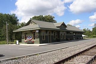
Orson is a village in Preston Township, Wayne County, Pennsylvania, United States, situated in the Lake Region of the Poconos. It was once an important depot of the Scranton Division of the New York, Ontario & Western (O&W) Railway, but today, when it is known outside of its immediate vicinity, it is largely for being the site of the intersection of two state roads, Belmont Turnpike and Crosstown Highway, or as the location of Independent Lake Camp (ILC), since ILC's reputation and commercial reach, like those of most rural American summer camps, extend beyond the community in which the camp is physically located.

Gouldsboro State Park is a 2,880-acre (1,165 ha) Pennsylvania state park in Coolbaugh Township, Monroe County and Lehigh Township, Wayne County, Pennsylvania in the United States. The park includes the 250-acre (100 ha) Gouldsboro Lake. Gouldsboro State Park is located very close to Tobyhanna State Park and Pennsylvania State Game Lands 127 and 312. It is on Pennsylvania Route 507 near the small village of Gouldsboro.

Memorial Lake State Park is a Pennsylvania state park on 230 acres (93 ha) in East Hanover Township, Dauphin County, Pennsylvania in the United States. The park is surrounded by Fort Indiantown Gap Military Reservation, headquarters of the Pennsylvania National Guard. It includes Memorial Lake, which is 85 acres (34 ha), and is a 30-minute drive from Harrisburg just off Exit 85 of Interstate 81.
Gouldsboro is a village and census-designated place (CDP) in Lehigh Township in Wayne County, and Coolbaugh Township, in Monroe County, Pennsylvania, United States. The CDP's population was 750 at time of the 2020 United States Census.
Starlight is a village that is located in Buckingham Township, Wayne County, Pennsylvania, United States. Crosstown Highway, which is entirely concurrent with Pennsylvania Route 370 (PA-370), is generally thought to be the southern edge of the village.

Wayne Highlands is a third-class school district in Wayne County, Pennsylvania. The district's population was 20,870 at the time of the 2010 United States Census.

Poyntelle is a village that is located in Preston Township, Wayne County, Pennsylvania, United States, in the Lake Region of the Poconos.

Lakewood is a village that is located in Preston Township, Wayne County, Pennsylvania, United States. It is situated on Pennsylvania Route 370 (PA-370), approximately 7 miles (11 km) east of Thompson, Pennsylvania and about 10 miles (16 km) southwest of Hancock, New York.
The East Branch Lackawanna River is a tributary of the Lackawanna River in Wayne County and Susquehanna County, in Pennsylvania, in the United States. It is approximately 12.7 miles (20.4 km) long and flows through Preston Township in Wayne County and Ararat Township, Herrick Township, Union Dale, and Clifford Township. The watershed of the river has an area of 19.0 square miles (49 km2). The river is not designated as impaired and has a relatively high level of water quality. A portion of the Moosic Mountains are in its vicinity. Source ponds in the river's watershed include Bone Pond, Dunns Pond, Independent Lake, Lake Lorain, Mud Pond, and Orson Pond. There are a number of wetlands and swamps in the watershed, but agricultural and forested land is present as well.

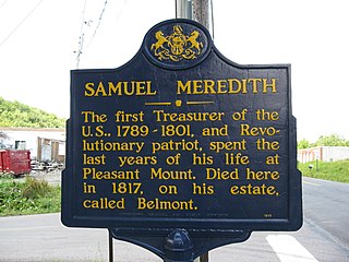
Pleasant Mount is an unincorporated community in Mount Pleasant Township, Wayne County, Pennsylvania, United States.


