Related Research Articles

Schuylkill County is a county in the U.S. state of Pennsylvania. As of the 2020 census, the population was 143,049. The county seat is Pottsville. The county was created on March 1, 1811, from parts of Berks and Northampton counties and named for the Schuylkill River, which originates in the county. On March 3, 1818, additional territory in its northeast was added from Columbia and Luzerne counties. The county is part of the Pottsville, Pennsylvania Micropolitan Statistical Area and is located in the heart of the Coal Region of eastern Pennsylvania.

Columbia County is a county located in Northeast Pennsylvania. As of the 2020 census, the population was 64,727. Its county seat is Bloomsburg. The county was created on March 22, 1813, from part of Northumberland County. It was named Columbia, alluding to the United States and Christopher Columbus.

Auburn is a borough in Schuylkill County, Pennsylvania, United States. The population was 663 at the 2020 census.

Beurys Lake is a census-designated place in Schuylkill County, Pennsylvania, United States. The population was 133 at the 2000 census.

Cressona is a borough in Schuylkill County, Pennsylvania, United States. Formed in 1857 from part of North Manheim Township, it was founded by and named for John Chapman Cresson, a Philadelphia civil engineer and manager of the Schuylkill Navigation Company, President of the Mine Hill and Schuylkill Haven Railroad and chief engineer of Fairmount Park, Philadelphia. Richard J. Wright is the acting mayor of Cressona, Pennsylvania.

Frackville is a borough in Schuylkill County, Pennsylvania, United States, incorporated in 1876. Today the intersection of Interstate 81 and Pennsylvania State Route 61 is located near the borough, which is approximately 102 miles (164 km) northwest of Philadelphia and 60 miles (97 km) southwest of Scranton. Frackville is named for Daniel Frack, an early Anglo-American settler.

Pine Grove Township is a township in Schuylkill County, Pennsylvania, United States. The population was 4,024 at the 2020 census.

Seltzer is a census-designated place (CDP) in Schuylkill County, Pennsylvania, United States. The population was 307 at the 2000 census. Seltzer is located in Norwegian Township.

Tremont Township is a township in Schuylkill County, Pennsylvania, United States. The population was 280 at the 2020 census.

Upper Mahantongo Township is a township in Schuylkill County, Pennsylvania, United States. The population was 614 at the 2020 census.

Washington Township is a township in Schuylkill County, Pennsylvania, United States. The population was 3,134 at the 2020 census.

Wayne Township is a township in Schuylkill County, Pennsylvania, United States. The population was 5,226 at the 2020 census. The township includes the village of Reedsville which contains a medium size state police barracks. Children from this township attend schools in the Blue Mountain School District. The township is divided by north-to-south PA Route 183 which serves as a highway connecting Schuylkill and Berks Counties. The Schuylkill County Fairgrounds are located in the township off east-to-west PA Route 895. 183 and 895 meet in the Census Designated Place of Summit Station.
West Brunswick Township is a township in Schuylkill County, Pennsylvania, United States. Brunswick Township was formed in 1801 as one of the original townships of Schuylkill County, being named for Brunswick (Braunschweig), Germany. In 1835, Brunswick Township was divided into East and West Brunswick Townships. Among the village names in the township are Molino, Pinedale and Frisbie.
Ashland is a borough in Schuylkill County in the U.S. state of Pennsylvania, 15 miles (24 km) northwest of Pottsville. A small part of the borough also lies in Columbia County, although all of the population resided in the Schuylkill County portion as of the 2020 census. The borough lies in the anthracite coal region of eastern Pennsylvania. Settled in 1850, Ashland was incorporated in 1857, and was named for Henry Clay's estate near Lexington, Kentucky. The population in 1900 was 6,438, and in 1940, 7,045, but had dropped to 2,471 at the 2020 census.

Swatara Creek is a 72-mile-long (116 km) tributary of the Susquehanna River in east-central Pennsylvania in the United States. It rises in the Appalachian Mountains in central Schuylkill County and passes through northwest Lebanon County before draining into the Susquehanna at Middletown in Dauphin County.

Tulpehocken Creek is a 39.5-mile-long (63.6 km) tributary of the Schuylkill River in southeastern Pennsylvania in the United States, and during the American Canal Age, once provided nearly half the length of the Union Canal linking the port of Philadelphia, the largest American city and the other communities of Delaware Valley with the Susquehanna basin and the Pennsylvania Canal System connecting the Eastern seaboard to Lake Erie and the new settlements of the Northwest Territory via the Allegheny}, Monongahela. and Ohio Rivers at Pittsburgh.
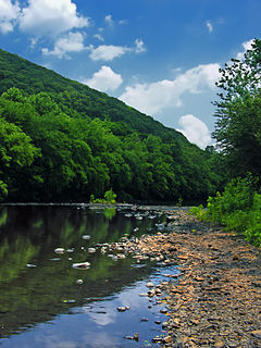
The Little Schuylkill River is a 30.6-mile-long (49.2 km) tributary of the Schuylkill River in Northeastern Pennsylvania.

The Federal Correctional Institution, Schuylkill is a medium-security United States federal prison for male inmates in Pennsylvania. It is operated by the Federal Bureau of Prisons, a division of the United States Department of Justice. The facility has an adjacent minimum-security satellite prison camp which also houses male offenders.
Nolo is an unincorporated community in Indiana County, in the U.S. state of Pennsylvania.
Soldier is an unincorporated community in Jefferson County, in the U.S. state of Pennsylvania.
References
- ↑ U.S. Geological Survey Geographic Names Information System: Fearnot, Pennsylvania
- ↑ "Schuylkill County". Jim Forte Postal History. Retrieved 16 March 2015.
- ↑ "From Panic to Tranquility". Reading Eagle. Apr 7, 2003. pp. B7. Retrieved 25 May 2015.
- ↑ Moyer, Armond; Moyer, Winifred (1958). The origins of unusual place-names. Keystone Pub. Associates. p. 49.
