Gordon, Pennsylvania

Last updated
Gordon, Pennsylvania
Borough
Gordon, Pennsylvania.JPG
View of Gordon, Pennsylvania
Schuylkill County Pennsylvania Incorporated and Unincorporated areas Gordon Highlighted.svg
Location of Gordon in Schuylkill County, Pennsylvania.
USA Pennsylvania location map.svg
Red pog.svg
Gordon
Location in Pennsylvania
Usa edcp location map.svg
Red pog.svg
Gordon
Gordon (the United States)
Coordinates: 40°45′03″N76°20′22″W / 40.75083°N 76.33944°W / 40.75083; -76.33944 Coordinates: 40°45′03″N76°20′22″W / 40.75083°N 76.33944°W / 40.75083; -76.33944
Country United States
State Pennsylvania
County Schuylkill
Settled1856
Incorporated1891
Government
  TypeBorough Council
  MayorGeorge Brocious
Area
[1]
  Total0.59 sq mi (1.54 km2)
  Land0.59 sq mi (1.54 km2)
  Water0.00 sq mi (0.00 km2)
Population
 (2020) [2]
  Total761
  Density1,283.31/sq mi (495.51/km2)
Time zone UTC-5 (Eastern (EST))
  Summer (DST) UTC-4 (EDT)
Zip code
17936
Area code 570
FIPS code 42-30128

Gordon is a borough in Schuylkill County, Pennsylvania, United States. The population was 765 at the 2020 census. [3]

Contents

Geography

Gordon is located at 40°45′3″N76°20′22″W / 40.75083°N 76.33944°W / 40.75083; -76.33944 (40.750943, -76.339447). [4]

According to the United States Census Bureau, the borough has a total area of 0.6 square miles (1.6 km2), all land.

Gordon is located north of Interstate 81.

History

The community is named after David F. Gordon, a judge. [5] The post office at Gordon was established July 15, 1858, with J. Faust as the first postmaster. [6]

Demographics

Historical population
CensusPop.
1880 753
1890 1,19458.6%
1900 1,165−2.4%
1910 1,1851.7%
1920 1,078−9.0%
1930 1,069−0.8%
1940 1,062−0.7%
1950 1,039−2.2%
1960 888−14.5%
1970 856−3.6%
1980 8924.2%
1990 768−13.9%
2000 7811.7%
2010 763−2.3%
2020 7650.3%
2021 (est.)766 [3] 0.1%
Sources: [7] [8] [9] [2]

At the 2000 census there were 781 people, 312 households, and 210 families living in the borough. The population density was 1,230.7 people per square mile (478.6/km²). There were 340 housing units at an average density of 535.8 per square mile (208.4/km²). The racial makeup of the borough was 98.72% White, 0.38% Native American, 0.26% Asian, 0.26% from other races, and 0.38% from two or more races. Hispanic or Latino of any race were 0.51%. [8]

Of the 312 households 33.7% had children under the age of 18 living with them, 51.9% were married couples living together, 12.5% had a female householder with no husband present, and 32.4% were non-families. 30.4% of households were one person and 18.3% were one person aged 65 or older. The average household size was 2.50 and the average family size was 3.12.

The age distribution was 25.5% under the age of 18, 9.6% from 18 to 24, 26.9% from 25 to 44, 23.6% from 45 to 64, and 14.5% 65 or older. The median age was 38 years. For every 100 females there were 96.2 males. For every 100 females age 18 and over, there were 96.0 males.

The median household income was $30,855 and the median family income was $40,714. Males had a median income of $28,125 versus $21,354 for females. The per capita income for the borough was $13,873. About 9.8% of families and 11.3% of the population were below the poverty line, including 12.2% of those under age 18 and 11.1% of those age 65 or over.

Related Research Articles

<span class="mw-page-title-main">Millersville, Pennsylvania</span> Borough in Pennsylvania, United States

Millersville is a borough in Lancaster County, Pennsylvania, United States. At the 2020 census the population was 7,629 and in 2021 it was estimated at 7,593.

<span class="mw-page-title-main">Applewold, Pennsylvania</span> Borough in Pennsylvania, United States

Applewold is a borough in Armstrong County, Pennsylvania, United States. The population was 310 at the 2010 census.

<span class="mw-page-title-main">Centerport, Pennsylvania</span> Borough in Pennsylvania, United States

Centerport is a borough in north central Berks County, Pennsylvania, United States. The population was 387 at the 2010 census.

<span class="mw-page-title-main">Aristes, Pennsylvania</span> Census-designated place in Pennsylvania, United States

Aristes is a census-designated place (CDP) in Conyngham Township, Columbia County, Pennsylvania, United States. The population was 311 at the 2010 census. It is part of the Bloomsburg–Berwick Micropolitan Statistical Area. Aristes is located adjacent to the famous "ghost town" of Centralia.

<span class="mw-page-title-main">New Cumberland, Pennsylvania</span> Borough in Pennsylvania, United States

New Cumberland is a borough in easternmost Cumberland County, Pennsylvania, United States. New Cumberland was incorporated on March 21, 1831. The population was 7,277 at the 2010 census. The borough is noted for its historic downtown which includes landmarks like the historic West Shore Theater and the yearly Apple Festival, which gathers hundreds of vendors and thousands of visitors.

<span class="mw-page-title-main">Gratz, Pennsylvania</span> Borough in Pennsylvania, United States

Gratz is a borough in Dauphin County, Pennsylvania, United States. The population was 743 at the 2020 census, down from 765 at the 2010 census. It is part of the Harrisburg–Carlisle Metropolitan Statistical Area.

<span class="mw-page-title-main">Highspire, Pennsylvania</span> Borough in Pennsylvania, United States

Highspire is a borough in Dauphin County, Pennsylvania, United States. The population was 2,736 at the 2020 census, up from 2,399 at the 2010 census. It is part of the Harrisburg–Carlisle Metropolitan Statistical Area.

<span class="mw-page-title-main">Williamstown, Pennsylvania</span> Borough in Pennsylvania, United States

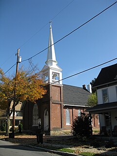
Williamstown is a borough in Dauphin County, Pennsylvania, United States, 38 miles (61 km) northeast of Harrisburg. Formerly, anthracite coal mines were here, as well as hosiery mills. The population was 1,303 at the 2020 census.

<span class="mw-page-title-main">Cleona, Pennsylvania</span> Borough in Pennsylvania, United States

Cleona is a borough in Lebanon County, Pennsylvania, United States. It is part of the Lebanon, Pennsylvania Metropolitan Statistical Area. The population was 2,005 at the 2020 census.

<span class="mw-page-title-main">Snydertown, Northumberland County, Pennsylvania</span> Borough in Pennsylvania, United States

Snydertown is a borough in Northumberland County, Pennsylvania, United States. As of the 2010 census, the borough population was 339.

<span class="mw-page-title-main">Auburn, Pennsylvania</span> Borough in Pennsylvania, United States

Auburn is a borough in Schuylkill County, Pennsylvania, United States. The population was 663 at the 2020 census.

<span class="mw-page-title-main">Cressona, Pennsylvania</span> Borough in Pennsylvania, United States

Cressona is a borough in Schuylkill County, Pennsylvania, United States. Formed in 1857 from part of North Manheim Township, it was founded by and named for John Chapman Cresson, a Philadelphia civil engineer and manager of the Schuylkill Navigation Company, President of the Mine Hill and Schuylkill Haven Railroad and chief engineer of Fairmount Park, Philadelphia. Richard J. Wright is the acting mayor of Cressona, Pennsylvania.

<span class="mw-page-title-main">Deer Lake, Pennsylvania</span> Borough in Pennsylvania, United States

Deer Lake is a borough in Schuylkill County, Pennsylvania, United States. The population was 687 at the 2010 census. The mayor of the borough is Larry Kozlowski.

<span class="mw-page-title-main">Landingville, Pennsylvania</span> Borough in Pennsylvania, United States

Landingville is a borough in Schuylkill County, Pennsylvania, United States. The population was 137 at the 2020 census.

<span class="mw-page-title-main">Mechanicsville, Schuylkill County, Pennsylvania</span> Borough in Pennsylvania, United States

Mechanicsville is a borough in Schuylkill County, Pennsylvania, United States. The population was 463 at the 2020 census. The borough lies between Pottsville and Port Carbon. Pottsville Street is the main street of town. The borough of part of the Pottsville Area School District.

<span class="mw-page-title-main">Middleport, Pennsylvania</span> Borough in Pennsylvania, United States

Middleport is a borough in Schuylkill County, Pennsylvania, United States. The population was 363 at the 2020 census. The town was named for being mid-point of 16-mile distance between Pottsville and Tamaqua.

<span class="mw-page-title-main">Palo Alto, Pennsylvania</span> Borough in Pennsylvania, United States

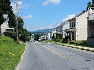
Palo Alto is a borough in Schuylkill County, Pennsylvania, United States. The population was 971 at the 2020 census. The borough stretches along the south bank of the Schuylkill River. Bacon Street is the main street of town. The borough shares Pottsville's ZIP Code, telephone exchanges, and school district. The borough maintains its own fire department and police department.

<span class="mw-page-title-main">Tremont, Pennsylvania</span> Borough in Pennsylvania, United States

Tremont is a borough in Schuylkill County, Pennsylvania, United States. The population was 1,672 at the 2020 census.

<span class="mw-page-title-main">Hollsopple, Pennsylvania</span> Borough in Pennsylvania, United States

Benson is a borough in Somerset County, Pennsylvania, United States. The town is more commonly known to locals as Hollsopple, which is also the United States Postal Service name for the town, zip code 15935. The population was 185 at the 2020 census. It is part of the Johnstown, Pennsylvania Metropolitan Statistical Area. Benson is served by the Conemaugh Township Area School District.

<span class="mw-page-title-main">York Haven, Pennsylvania</span> Borough in Pennsylvania, United States

York Haven is a borough in York County, Pennsylvania, United States. The population was 691 at the 2020 census. The borough is the home of the Brunner Island coal-fired electrical generation plant, located on the Susquehanna River on Wago Road and operated by PPL Corporation.

References

  1. "ArcGIS REST Services Directory". United States Census Bureau. Retrieved October 12, 2022.
  2. 1 2 "Census Population API". United States Census Bureau. Retrieved Oct 12, 2022.
  3. 1 2 Bureau, US Census. "City and Town Population Totals: 2020—2021". Census.gov. US Census Bureau. Retrieved August 1, 2022.
  4. "US Gazetteer files: 2010, 2000, and 1990". United States Census Bureau. 2011-02-12. Retrieved 2011-04-23.
  5. Espenshade, A. Howry [1925] (1969) Pennsylvania Place Names, pp 275-276 Detroit, Mich: Gale Research Company
  6. Kay, John L. and Smith, Chester M. (1976) Pennsylvania Postal History, p. 304, Lawrence, Massachusetts: Quarterman Publications Inc., ISBN   0-88000-059-7
  7. "Census of Population and Housing". U.S. Census Bureau. Retrieved 11 December 2013.
  8. 1 2 "U.S. Census website". United States Census Bureau . Retrieved 2008-01-31.
  9. "Incorporated Places and Minor Civil Divisions Datasets: Subcounty Resident Population Estimates: April 1, 2010 to July 1, 2012". Population Estimates. U.S. Census Bureau. Archived from the original on 11 June 2013. Retrieved 11 December 2013.