Schuylkill Haven, Pennsylvania

Last updated
Schuylkill Haven, Pennsylvania
Borough
Schuylkill Haven, Pennsylvania (8483002029).jpg
A Schuylkill Haven church in May 2012
Flag of Schuylkill Haven, Pennsylvania.png
Seal of Schuylkill Haven, Pennsylvania.png
Nickname: 
"The Little Town That Could"
Schuylkill County Pennsylvania Incorporated and Unincorporated areas Schuylkill Haven Highlighted.svg
Location of Schuylkill Haven in Schuylkill County, Pennsylvania (left) and of Schuylkill County in Pennsylvania (right)
USA Pennsylvania location map.svg
Red pog.svg
Schuylkill Haven
Location of Schuylkill Haven in Pennsylvania
Usa edcp location map.svg
Red pog.svg
Schuylkill Haven
Schuylkill Haven (the United States)
Coordinates: 40°37′41″N76°10′21″W / 40.62806°N 76.17250°W / 40.62806; -76.17250
Country United States
State Pennsylvania
County Schuylkill
Settled1750
IncorporatedJune 11, 1840
Government
  TypeMayor and Borough Council
  MayorMike Devlin (D)
Area
[1]
  Total1.40 sq mi (3.64 km2)
  Land1.40 sq mi (3.62 km2)
  Water0.01 sq mi (0.01 km2)
Elevation
526 ft (160 m)
Population
 (2020) [2]
  Total5,236
  Density3,745.35/sq mi (1,446.03/km2)
Time zone UTC-5 (Eastern (EST))
  Summer (DST) UTC-4 (EDT)
Zip Code
17972
Area code(s) 570 and 272
FIPS code 42-68312
Website http://www.schuylkillhaven.org

Schuylkill Haven is a borough in Schuylkill County, Pennsylvania, United States. The borough's population was 5,253 as of the 2020 census. [3] Schuylkill Haven is situated along the Schuylkill River, for which it is named. Schuylkill Haven is a focal point of activity in southern Schuylkill County.

Contents

Schuylkill Haven is located 43.4 miles (69.8 km) west of Allentown, 92.6 miles (149.0 km) northwest of Philadelphia, and 131 miles (211 km) west of New York City.

History

Aerial photograph of Schuylkill Haven and surrounding areas in June 2023 SchuylkillHavenAerial.jpg
Aerial photograph of Schuylkill Haven and surrounding areas in June 2023

Before Europeans settled the land that is present-day Schuylkill Haven, the area was occupied by the Lenape Indian tribe, who were known as the Delaware Indians by the British.

The earliest European settlers arrived in the area of present-day Schuylkill Haven in the 1730s. They traveled north of Blue Mountain at the present-day Berks-Schuylkill County line at that time.

The first settler in Schuylkill Haven was John Fincher, a Quaker from Chester County, Pennsylvania, who received a land grant of 225 acres (0.91 km2) on March 5, 1750, the day Schuylkill Haven considers its unofficial founding. Fincher constructed a house and barn near the Schuylkill River, and called his small settlement "Fincher's Ford."

The second known settler of Schuylkill Haven was Martin Dreibelbis, a German who arrived in the Spring of 1775. Martin Dreibelbis constructed a house, saw mill, distillery, and a grist mill on the eastern bank of the Schuylkill River. He later built a log house near present-day Main Street, giving Dreibelbis the title as Schuylkill Haven's "first resident". Dreibelbis willed his original plot of the town to his son, Jacob. Another son, Daniel, received an area east of the original plot, and a third son, George, received an area known as "Seven Stars", located north of Schuylkill Haven on the Schuylkill River.

The original plot of Schuylkill Haven shows that the borough stretched from the Schuylkill River on the west to present-day Main Street on the north, then known as Front Street, to Saint Peter Street on the east, then known as Jacob Street, and Liberty Street on the south. Present-day Columbia Street was initially the main residential district. [4]

Geography and climate

Schuylkill Haven was developed around the Schuylkill River, which flows through the town entering northwest of Island Park near Fritz Reed Avenue, and exits at the southeastern border. The river's elevation in the borough is approximately 490 feet (150 m) above sea level. Farther from the river, the borough extends up numerous hills, reaching its highest elevation at approximately 700 feet (210 m) above sea level near the top of Avenue C.

Schuylkill Haven receives an average of 47 inches (1,200 mm) of rain annually. The warmest month is typically July with an average high temperature of 84 °F (29 °C), and the coolest month is typically January with an average high of 36 °F (2 °C). [5] The hardiness zone is now 7a. The borough has a hot-summer humid continental climate (Dfa) and average monthly temperatures range from 28.1 °F in January to 73.1 °F in July.

According to the U.S. Census Bureau, the borough has a total area of 1.4 square miles (3.6 km2), all of which is land.

Services and facilities

Schuylkill Haven provides electric, water, sewer, and refuse services to citizens of the borough. The borough purchases electricity from AMP Ohio and Allegheny. [6] The Tumbling Run Reservoir, located approximately five miles (8 km) north of the borough, is the Schuylkill Haven's primary source of water. Storage tanks at Willow Lake at the northern edge of the borough are an additional part of the borough's water facilities. Schuylkill Haven owns a second watershed located in Wayne Township with a small portion extending into Branch Township, known as the Panther Valley dam. This water supply is no longer used but the earthen dam still exists. Schuylkill Haven's sewage treatment plant is located at the southern edge of town, on the western side of St. Charles Street.

Schuylkill Haven's borough hall was once located in the Schuylkill Haven station on Main Street. In July 2015, however, it was moved to 333 Centre Avenue on PA Route 61.

Schuylkill Haven is served by its own police force. The Schuylkill Haven Police Department has eight officers, which provided service 24 hours a day, 7 days a week, with at least two officers typically on duty at all times. The police station and council chambers are headquartered on Parkway.

Schuylkill Haven has a volunteer fire department. The borough has three fire stations: The Rainbow Hose Co. (Station 1) on Dock Street, the Schuylkill Hose Co. (Station 2) at Union and St. Peter Streets, and the Liberty Fire Co. (Station 4) at Columbia and St. James Streets. Friendship Fire Co. (Station 3) was in close proximity to Rainbow, and was discontinued in the 19th century.

Parks and recreation

The Schuylkill Haven Fire Department in May 2012 Schuylkill Haven, Pennsylvania (8484096064).jpg
The Schuylkill Haven Fire Department in May 2012

Schuylkill Haven has several playgrounds and recreation areas, including Green Goose on Jackson Street west of Avenue A, Saylor Street playground on the western side of the borough, Naffin Avenue playground on Naffin Avenue northwest of the public school district's main athletic field, and Willow Street playground in the northwestern corner of the borough. Other children's play areas are on Garfield Avenue, North Berne Street, Williams Street, and Fritz Reed Avenue. On South Berne Street is an area known as "The Courts", which features a basketball court, picnic benches, and a gazebo.

Bubeck Park is located south of Columbia street near the Columbia Heights section of the borough. The park includes two pavilions, a bandstand, and a gazebo. Situated at the eastern edge of Bubeck Park is Stoyer's Dam, a man-made damn dedicated on May 20, 1984, and used for fishing and ice skating. The dam has numerous ducks, geese, and swans. The source of water for the dam is Long Run Creek, which enters on the western side of the dam after traveling along PA Route 443 from the Friedensburg area.

Island Park, located south of Fritz Reed Avenue between the Schuylkill River and the Reading Blue Mountain and Northern Railroad, is the latest addition to Schuylkill Haven's park system. Island park is the site of fireworks displays in the borough. The park also includes two baseball fields, several soccer fields, and a large pavilion. It is also the starting point of the Schuylkill County Sojurn", a kayaking trip down the Schuylkill River from Schuylkill Haven to Philadelphia.

The Community Center, also known as the Recreation Center or the Senior Center, is located at 340 Haven Street. Senior citizen events, biddy basketball, and internet access are available at the center. A gym and two rooms are available to rent for meetings, showers, and small parties. The center is handicap accessible.

The Walk In Art Center in Schuylkill Haven features 15 on-site artists and three art galleries and offers educational programs and community events. [7]

Religion

Schuylkill Haven has ten Protestant churches, a Catholic Church, and a Mandir, Vraj Hindu Temple, all located in Schuylkill Haven. The churches include:

Demographics

Historical population
CensusPop.Note
1850 2,071
1860 2,92741.3%
1870 2,9400.4%
1880 3,0523.8%
1890 3,0881.2%
1900 3,65418.3%
1910 4,74729.9%
1920 5,43714.5%
1930 6,51419.8%
1940 6,5180.1%
1950 6,5971.2%
1960 6,470−1.9%
1970 6,125−5.3%
1980 5,977−2.4%
1990 5,610−6.1%
2000 5,548−1.1%
2010 5,437−2.0%
2020 5,253−3.4%
2021 (est.)5,258 [3] 0.1%
U.S. Decennial Census [8]

As of the 2010 census, there were 5,437 people, 2,330 Households, and 1,417 families residing in the borough. The racial makeup of the borough was 94.5% White, 2.1% Hispanic or Latino ancestry of any race, 2.5% Black or African American, 0.9% Asian, 1.3% were two or more races, 0.4% were some other race and 0.2% Native American. [9] As of the 2020 census, the borough's population was 5,253.

Government and politics

Schuylkill Haven is governed by a borough council and a mayor. There are seven borough council members. Both the mayor and council members are elected to a four-year term. There are no term limits for council members or the mayor. Borough council meetings are typically held on the first and third Wednesdays of each month in council chambers in the borough's police station at 250 Parkway. In addition to the council and the mayor, a borough administrator leads the municipality's daily operations from a borough office at 333 Center Avenue, which is part of PA Route 61.

Schuylkill Haven is in Pennsylvania's 9th congressional district, currently represented by U.S. Congressman Dan Meuser (R).

On the state level, it is in the 29th Pennsylvania Senate District represented by State Senator is Dave Argall (R) and the 125th Pennsylvania House of Representatives District, represented by Joseph Kerwin (R).

Education

Primary and secondary education

Schuylkill Haven is in the Schuylkill Haven Area School District. Students in grades eight through twelve attend Schuylkill Haven High School. The district also maintains a middle school and an elementary school.

Colleges and universities

Entrance to Penn State Schuylkill in Schuylkill Haven in August 2018 Penn State Schuylkill.jpg
Entrance to Penn State Schuylkill in Schuylkill Haven in August 2018

Penn State Schuylkill, part of the Pennsylvania State University system, is located off PA Route 61 immediately northeast of the borough. It offers five associate degrees, and the opportunity to complete the first two years of 160 majors, and to matriculate to Penn State after these first two years.

Public library

Schuylkill Haven Free Public Library, located at 104 St. John Street at the intersection of St. John and Union Street, was dedicated on June 26, 1966. The library is open Monday through Saturday.

Transportation

Highways and roads

Schuylkill Haven is served by two state highways, Pennsylvania Route 61 and Pennsylvania Route 443.

PA Route 61, a north–south highway, travels through the northern part of the borough. PA Route 61 operates as "Center Avenue" in Schuylkill Haven. The road continues north to Pottsville and ends in Sunbury; its southbound rout enters Berks County, Pennsylvania, where it ends in Reading.

PA Route 443 enters Schuylkill Haven at the western end of the borough, where it is known as Columbia Street. It continues on Parkway to Main Street until it enters Dock Street. PA Route 443 exits the town along with PA Route 61 on the northeastern side of the borough. PA Route 443 continues east toward Orwigsburg, and west toward Pine Grove.

Interstate 81 is accessible from PA Route 443 near Pine Grove. Interstate 78 is accessinble nearby at Hamburg in Berks County from PA Route 61, which recently underwent a $65 million widening project. [10]

Trains

Reading Blue Mountain and Northern Railroad's commercial train service traverses the borough on a single-track line with three grade crossings, at Williams Street, Union Street, and Main Street.

Passenger train service by SEPTA was available between Schuylkill Haven, Reading, and Philadelphia [11] until July 1, 1981, when PennDOT withdrew its financial support for the project. Schuylkill Haven station is now owned and operated by Reading Blue Mountain and Northern Railroad.

Schuylkill Canal

The Schuylkill Canal, created by the Schuylkill Navigation Company, was incorporated into Schuylkill Haven's transportation system in 1825. The canal was built on the Schuylkill River as a means to transport anthracite coal and traveled from Philadelphia to Port Carbon. The canal turned Reading, Norristown, and Pottsville into manufacturing centers.

In 1841, the Philadelphia and Reading Railroad was founded. By 1845, it was transporting nearly three times as much coal than the Schuylkill Canal. The Schuylkill Navigation Company expanded their canals to accommodate for larger boats. But in 1869, the canals were damaged from flooding, and their use began declining. The railroads ultimately surpassed canals as the primary transportation for coal. In 1979, the canals were filled by the Commonwealth of Pennsylvania.

Notable people

Related Research Articles

<span class="mw-page-title-main">Schuylkill County, Pennsylvania</span> County in Pennsylvania, United States

Schuylkill County is a county in the Commonwealth of Pennsylvania. It is located in the heart of Pennsylvania's Coal Region and is part of Northeastern Pennsylvania. As of the 2020 census, the population was 143,049. The county seat is Pottsville.

<span class="mw-page-title-main">Bernville, Pennsylvania</span> Borough in Pennsylvania, United States

Bernville is a borough in Berks County, Pennsylvania, United States. The population was 905 at the 2020 census. Bernville is bordered by Penn Township to the north, east, and south and by Jefferson Township to the west. It is believed by few that the borough would have been a county seat of a small county called Tulpehocken County. However, no official sources can be found.

<span class="mw-page-title-main">Birdsboro, Pennsylvania</span> Borough in Pennsylvania, United States

Birdsboro is a borough in Berks County, Pennsylvania, United States. It is located along the Schuylkill River 8 miles (13 km) southeast of Reading. As of the 2020 census, it had a population of 5,106. Birdsboro's economy had historically been rooted in large foundries and machine shops, none of which remain in operation today.

<span class="mw-page-title-main">Hamburg, Pennsylvania</span> Borough in Pennsylvania, United States

Hamburg is a borough in Berks County, Pennsylvania, United States. The population was 4,270 at the 2020 census. The town is thought to have been named after Hamburg, Germany, but this is likely to have been a corruption of Bad Homburg.

<span class="mw-page-title-main">Leesport, Pennsylvania</span> Borough in Pennsylvania, United States

Leesport is a borough in Berks County, Pennsylvania, United States. The population was 1,954 at the 2020 census.

<span class="mw-page-title-main">Phoenixville, Pennsylvania</span> Borough in Pennsylvania, United States

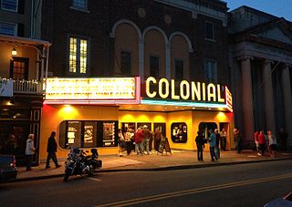
Phoenixville is a borough in Chester County, Pennsylvania, United States. It is located 28 miles (45 km) northwest of Philadelphia at the junction of French Creek and the Schuylkill River. It is in the Philadelphia metropolitan area. According to a 2022 estimate, the population was 19,354.

<span class="mw-page-title-main">Upper Providence Township, Montgomery County, Pennsylvania</span> Township in Pennsylvania, United States

Upper Providence Township is a township in Montgomery County, Pennsylvania, United States. As of the 2010 census, the township population was 21,219.

<span class="mw-page-title-main">Mount Carbon, Pennsylvania</span> Borough in Pennsylvania, United States

Mount Carbon is a borough in Schuylkill County, Pennsylvania, United States, two miles south of Pottsville. It was formed from North Manheim Township in 1864. The population was 88 in the 2020 census. The borough is the smallest municipality in Schuylkill County.

<span class="mw-page-title-main">Pottsville, Pennsylvania</span> City in Pennsylvania, United States

Pottsville is a city and the county seat of Schuylkill County, Pennsylvania, United States. The population was 13,346 at the 2020 census, and is the principal city of the Pottsville, PA Micropolitan Statistical Area. The city lies along the west bank of the Schuylkill River, 52 miles (84 km) south of Wilkes-Barre. It is located in Pennsylvania's Coal Region.

<span class="mw-page-title-main">Tamaqua, Pennsylvania</span> Borough in Pennsylvania, United States

Tamaqua is a borough in eastern Schuylkill County in the Coal Region of Pennsylvania, United States. It had a population of 6,934 as of the 2020 U.S. census.

<span class="mw-page-title-main">Manayunk, Philadelphia</span> Neighborhood of Philadelphia in Pennsylvania, United States

Manayunk is a neighborhood in the section of Lower Northwest Philadelphia in the state of Pennsylvania. Located adjacent to the neighborhoods of Roxborough and Wissahickon and also on the banks of the Schuylkill River, Manayunk contains the first canal begun in the United States.

<span class="mw-page-title-main">Pennsylvania Route 61</span> State highway in Pennsylvania, US

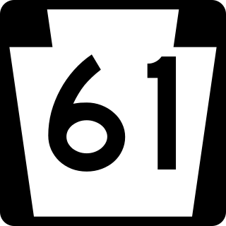
Pennsylvania Route 61 is an 81.8-mile-long (131.6 km) state highway that is located in Pennsylvania in the United States. The route is signed on a north–south direction, running from U.S. Route 222 Business in Reading northwest to US 11/US 15/PA 147 in Shamokin Dam.

<span class="mw-page-title-main">East Falls, Philadelphia</span> Neighborhood of Philadelphia in Philadelphia County, Pennsylvania, United States

East Falls is a neighborhood in Lower Northwest, Philadelphia, Pennsylvania, United States. It lies on the east bank of the "Falls of the Schuylkill," cataracts submerged in 1822 by the Schuylkill Canal and Fairmount Water Works projects. East Falls sits next to the Germantown, Roxborough, Allegheny West, and the Nicetown-Tioga neighborhoods. Wissahickon Valley Park separates it from Manayunk, Philadelphia.

<span class="mw-page-title-main">U.S. Route 422</span> Highway in Ohio and Pennsylvania

U.S. Route 422 (US 422) is a 271-mile-long (436 km) spur route of US 22 split into two segments in the U.S. states of Ohio and Pennsylvania. The western segment of US 422 runs from downtown Cleveland, Ohio, east to Ebensburg, Pennsylvania. The eastern segment, located entirely within Pennsylvania, runs from Hershey east to King of Prussia, near Philadelphia. US 422 Business serves as a business route into each of four towns along the way.

<span class="mw-page-title-main">Pennsylvania Route 724</span> State highway in Pennsylvania, US

Pennsylvania Route 724 is a 30-mile (48 km) road in the U.S. commonwealth of Pennsylvania that runs from U.S. Route 422 in Sinking Spring southeast to PA 23 near Phoenixville. PA 724 travels through Berks and Chester counties. The route runs through the southern suburbs of Reading, passing through Shillington and Kenhorst. Past the Reading area, PA 724 continues southeast parallel to the Schuylkill River, passing through or near Birdsboro, Pottstown, and Spring City. The route intersects many roads including US 222 near Shillington, PA 10 and Interstate 176 (I-176) southeast of Reading, PA 345 in Birdsboro, and PA 100 and US 422 near Pottstown.

<span class="mw-page-title-main">Schuylkill River Trail</span> Multi-use trail in Pennsylvania, United States

The Schuylkill River Trail is a multi-use trail along the banks of the Schuylkill River in southeastern Pennsylvania. Partially complete as of 2018, the trail is ultimately planned to run about 140 miles (230 km) from the river's headwaters in Schuylkill County to Fort Mifflin in Philadelphia.

<span class="mw-page-title-main">Pennsylvania Route 183</span> State highway in Pennsylvania, US

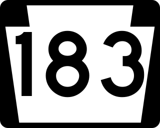
Pennsylvania Route 183 (PA 183) is a 31.7-mile-long (51.0 km) route that runs north to south in southeastern Pennsylvania. The southern terminus is at U.S. Route 422 Business in Reading in Berks County. Its northern terminus is at PA 61 near Schuylkill Haven in Schuylkill County. The road passes through developed areas near Reading before continuing north through rural areas, crossing from Berks County into Schuylkill County at Blue Mountain. PA 183 serves the communities of Bernville, Strausstown, and Cressona.

<span class="mw-page-title-main">Pennsylvania Route 443</span> State highway in Pennsylvania, US

Pennsylvania Route 443 is an 80-mile-long (130 km) east–west state highway in the US state of Pennsylvania. The western terminus is at an intersection with State Route 3009 at North Front Street on the east bank of the Susquehanna River in the community of Fort Hunter in Middle Paxton Township, just west of an interchange with the U.S. Route 22 /US 322 freeway. The eastern terminus is at US 209 in Lehighton. The route runs through rural areas in the Ridge-and-Valley Appalachians in Dauphin, Lebanon, Schuylkill, and Carbon counties, serving Fort Indiantown Gap, Pine Grove, Schuylkill Haven, Orwigsburg, New Ringgold, and South Tamaqua. PA 443 intersects several major roads, including US 22/US 322 near its western terminus, PA 72 in Union Township, Interstate 81 (I-81) near Pine Grove, PA 61 between Schuylkill Haven and Orwigsburg, and PA 309 in South Tamaqua.

<span class="mw-page-title-main">Pennsylvania Route 895</span> State highway in Pennsylvania, US

Pennsylvania Route 895 is a 47.37 mi (76.23 km) state highway in the U.S. state of Pennsylvania. It is an east–west route, running from PA 443 in Pine Grove in Schuylkill County east to and PA 248 in Bowmanstown in Carbon County. PA 895 is a two-lane undivided road that passes through rural areas in the southern sections of Schuylkill and Carbon counties, serving Auburn, Deer Lake, and New Ringgold. The entire course is close to the north flank of Blue Mountain. PA 895 was designated in 1928 between Auburn and U.S. Route 120 in Pinedale. In the 1930s, the route was extended west to PA 443 in Pine Grove and east to US 309 at White Street in Bowmanstown. In 1961, the east end was moved to an interchange with the PA 29/PA 45 freeway in Bowmanstown. Contrary to the highway’s designated number, it is not connected to or a bypass of Interstate 95, which runs in the Philadelphia area.

<span class="mw-page-title-main">U.S. Route 122 (1935–1963)</span> Former highway in Pennsylvania, United States

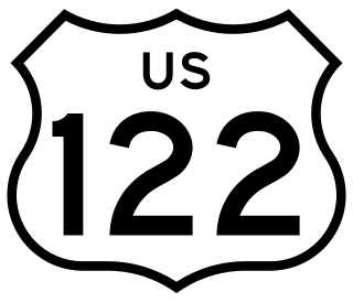
U.S. Route 122 was a United States Numbered Highway that was a spur of US 22. Located in the state of Pennsylvania, it existed from 1935 to 1963. At its greatest extent, the route ran from US 1 and Pennsylvania Route 472 in Oxford north to US 11 and PA 14 in Northumberland. Along the way, US 122 passed through Parkesburg, Honey Brook, Morgantown, Reading, Hamburg, Schuylkill Haven, Pottsville, Frackville, Ashland, Centralia, Mount Carmel, Shamokin, and Sunbury.

References

  1. "ArcGIS REST Services Directory". United States Census Bureau. Retrieved October 16, 2022.
  2. "Census Population API". United States Census Bureau. Retrieved Oct 12, 2022.
  3. 1 2 Bureau, US Census. "City and Town Population Totals: 2020—2021". Census.gov. US Census Bureau. Retrieved August 1, 2022.
  4. Schuylkill Haven 225th Anniversary Book (1975), pp. 10-12
  5. Average Weather for Schuylkill Haven, PA. The Weather Channel.
  6. "Utilities". Schuylkill Haven, PA. Retrieved November 27, 2019.
  7. "Walk In Art Center". My Website.
  8. "Census of Population and Housing". Census.gov. Retrieved June 4, 2016.
  9. "Schuylkill Haven, Pennsylvania". United States Census Bureau . Retrieved 23 January 2020.
  10. "PennDOT Plans Revamp of Route 61 in Schuylkill County". WNEP.com. 2018-10-04. Retrieved 2019-06-25.
  11. "Conrail Passenger Trains". Archived from the original on 2012-03-10. Retrieved 2014-08-21.