Friedensburg, Pennsylvania

Last updated
Friedensburg
CDP
Friedensburg, Pennsylvania (8482296556).jpg
USA Pennsylvania location map.svg
Red pog.svg
Friedensburg
Location within the U.S. state of Pennsylvania
Usa edcp location map.svg
Red pog.svg
Friedensburg
Friedensburg (the United States)
Coordinates: 40°36′16″N76°13′48″W / 40.60444°N 76.23000°W / 40.60444; -76.23000 Coordinates: 40°36′16″N76°13′48″W / 40.60444°N 76.23000°W / 40.60444; -76.23000
Country United States
State Pennsylvania
County Schuylkill
Area
[1]
  Total1.73 sq mi (4.49 km2)
  Land1.73 sq mi (4.49 km2)
  Water0.00 sq mi (0.00 km2)
Population
 (2020) [2]
  Total1,041
  Density600.69/sq mi (231.97/km2)
Time zone UTC-5 (Eastern (EST))
  Summer (DST) UTC-4 (EDT)
ZIP codes
17933
Area code(s) 570 and 272
FIPS code 42-27936

Friedensburg is a census-designated place (CDP) in Schuylkill County, Pennsylvania. The population was 828 at the time of the 2000 census.

Contents

Geography

Friedensburg is located at 40°36′16″N76°13′48″W / 40.60444°N 76.23000°W / 40.60444; -76.23000 (40.604343, -76.229900). [3]

According to the United States Census Bureau, the CDP has a total area of 1.6 square miles (4.1 km2), all of it land.

Demographics

Historical population
CensusPop.
2020 1,041
U.S. Decennial Census [4]

At the 2000 census there were 828 people, 375 households, and 241 families living in the CDP. The population density was 527.2 people per square mile (203.6/km2). There were 414 housing units at an average density of 263.6/sq mi (101.8/km2). The racial makeup of the CDP was 99.52% White, 0.12% Native American, 0.12% from other races, and 0.24% from two or more races. Hispanic or Latino of any race were 0.60%. [5]

Of the 375 households 23.2% had children under the age of 18 living with them, 50.7% were married couples living together, 8.5% had a female householder with no husband present, and 35.7% were non-families. 31.5% of households were one person and 16.0% were one person aged 65 or older. The average household size was 2.21 and the average family size was 2.70.

The age distribution was 19.8% under the age of 18, 5.6% from 18 to 24, 29.1% from 25 to 44, 25.4% from 45 to 64, and 20.2% 65 or older. The median age was 42 years. For every 100 females, there were 103.9 males. For every 100 females age 18 and over, there were 97.0 males.

The median household income was $33,625 and the median family income was $48,750. Males had a median income of $28,173 versus $25,714 for females. The per capita income for the CDP was $19,039. None of the families and 4.0% of the population were living below the poverty line, including no under eighteens and 4.5% of those over 64.

Related Research Articles

<span class="mw-page-title-main">Wilhoit, Arizona</span> CDP in Yavapai County, Arizona

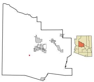
Wilhoit is a census-designated place (CDP) in Yavapai County, Arizona, United States. The population was 664 at the 2000 census.

Rock Island Arsenal is a census-designated place (CDP) in Rock Island County, Illinois, United States. The population was 149 at the 2010 census. The island contains the Rock Island National Cemetery.

Whitfield is a census-designated place (CDP) in Berks County, Pennsylvania, United States. The population was 4,733 at the 2010 census.

<span class="mw-page-title-main">Woodward, Pennsylvania</span> Census-designated place in Pennsylvania, United States

Woodward is an unincorporated community and census-designated place in Centre County, Pennsylvania, United States. It is part of the State College, Pennsylvania, Metropolitan Statistical Area. The population was 110 at the 2010 census.

<span class="mw-page-title-main">Wilburton Number One, Pennsylvania</span> Census-designated place in Pennsylvania, United States

Wilburton Number One is a census-designated place (CDP) in Columbia County, Pennsylvania, United States. The population was 196 at the 2010 census. It is part of the Bloomsburg–Berwick Micropolitan Statistical Area.

Altamont is a census-designated place (CDP) in Schuylkill County, Pennsylvania, USA. The population was 2,689 at the 2000 census.

Branchdale is a census-designated place (CDP) in Schuylkill County, Pennsylvania, United States. The population was 436 at the 2000 census.

<span class="mw-page-title-main">Buck Run, Pennsylvania</span> CDP in Pennsylvania, United States

Buck Run is a census-designated place (CDP) in Schuylkill County, Pennsylvania, United States. The population was 176 at the 2010 census.

<span class="mw-page-title-main">Delano, Pennsylvania</span> CDP in Pennsylvania, United States

Delano is a census-designated place (CDP) in Schuylkill County, Pennsylvania, United States. The population was 377 at the 2000 census.

<span class="mw-page-title-main">Donaldson, Pennsylvania</span> CDP in Pennsylvania, United States

Donaldson is a census-designated place (CDP) in Frailey Township, Schuylkill County, Pennsylvania, United States. The population was 325 at the 2000 census.

Englewood is a census-designated place (CDP) in Schuylkill County, Pennsylvania, United States. The population was 484 at the 2000 census.

Fountain Springs is a census-designated place in Butler Township, Schuylkill County, Pennsylvania, United States. The population was 100 at the 2000 census.

<span class="mw-page-title-main">Lake Wynonah, Pennsylvania</span> CDP in Pennsylvania, United States

Lake Wynonah is a census-designated place (CDP) in Schuylkill County, Pennsylvania, United States. The population was 1,961 at the 2000 census, and 2,640 at the 2010 census. Lake Wynonah is a gated community with two lakes, Fawn Lake and Lake Wynonah, and as of July 2008, there are over 1200 homes and 1500 members. It is in South Manheim and Wayne Townships.

McKeansburg is a census-designated place (CDP) in Schuylkill County, Pennsylvania, United States. The population was 155 at the 2000 census.

Ravine is a census-designated place (CDP) in Schuylkill County, Pennsylvania, United States. The population was 629 at the 2000 census.

<span class="mw-page-title-main">Shenandoah Heights, Pennsylvania</span> CDP in Pennsylvania, United States

Shenandoah Heights is a census-designated place (CDP) in Schuylkill County, Pennsylvania, United States. The population was 1,298 at the 2000 census.

<span class="mw-page-title-main">Emigsville, Pennsylvania</span> CDP in Pennsylvania, United States

Emigsville is a census-designated place (CDP) in York County, Pennsylvania, United States. The population was 2,672 at the 2010 census.

<span class="mw-page-title-main">Valley View, York County, Pennsylvania</span> CDP in Pennsylvania, United States

Valley View is a census-designated place (CDP) in York County, Pennsylvania, United States. The population was 2,817 at the 2010 census.

<span class="mw-page-title-main">Millwood, South Carolina</span> CDP in South Carolina, United States

Millwood is a census-designated place (CDP) in Sumter County, South Carolina, United States. The population was 885 at the 2000 census. It is included in the Sumter, South Carolina Metropolitan Statistical Area.

<span class="mw-page-title-main">Brookhurst, Wyoming</span> CDP in Wyoming, United States

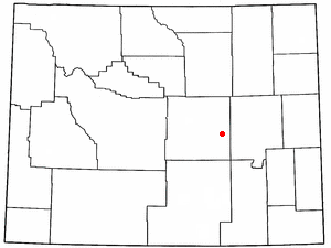
Brookhurst is a census-designated place (CDP) in Natrona County, Wyoming, United States. It is part of the Casper, Wyoming Metropolitan Statistical Area. The population was 185 at the 2010 census.

References

  1. "ArcGIS REST Services Directory". United States Census Bureau. Retrieved October 12, 2022.
  2. "Census Population API". United States Census Bureau. Retrieved Oct 12, 2022.
  3. "US Gazetteer files: 2010, 2000, and 1990". United States Census Bureau. 2011-02-12. Retrieved 2011-04-23.
  4. "Census of Population and Housing". Census.gov. Retrieved June 4, 2016.
  5. "U.S. Census website". United States Census Bureau . Retrieved 2008-01-31.