Freda, Michigan

Last updated
Freda, Michigan
FredaSmokestack.jpg
The remains of the smokestack of the Champion Mill
USA Michigan location map.svg
Red pog.svg
Freda
Coordinates: 47°08′07″N88°49′07″W / 47.13528°N 88.81861°W / 47.13528; -88.81861 Coordinates: 47°08′07″N88°49′07″W / 47.13528°N 88.81861°W / 47.13528; -88.81861
Country United States
State Michigan
County Houghton
Township Stanton
Elevation
[1]
738 ft (225 m)
Time zone UTC-5 (Eastern (EST))
  Summer (DST) UTC-4 (EDT)
ZIP code(s)
Area code 906
FIPS code 26-30440 [2]
GNIS feature ID626444 [1]
Superior View Restaurant Freda 2.JPG
Superior View Restaurant

Freda is an unincorporated community fifteen miles west of Houghton, United States in the Stanton Township. [1]

Contents

History

Freda was a key part of the copper industry in the Upper Peninsula of Michigan, on the western edge of the Keweenaw Peninsula. The large mill located in the town received copper ore from the surrounding region. The town was named after William A. Paine's daughter. [3] [4]

Freda and its companion, Beacon Hill, were owned and maintained by the Champion Mining Company, a subsidiary of Copper Range Consolidated. The town existed essentially to serve the large Champion Copper Mill, which processed copper-bearing rock from the nearby Champion Mines. The mill was served by the Copper Range Railroad, [5] which also provided passenger service to the area. A post office operated from July 12, 1907, until March 12, 1964. [6]

As a result of its location on a major railroad line, Freda became a holiday vacation spot. The Freda Park was opened in 1908, funded completely by the Copper Range Railroad. It maintained the title as the cleanest and best maintained park in the Copper Country. [7]

With the decline of peoples' reliance on the railroad system, the park was shut down on Labor Day in 1918, thus handicapping the Freda community. In a 1966 article in the Daily Mining Gazette, a reporter simply stated, “...only the files of newspapers, books, and periodicals will be mute evidence to days enjoyed of yesteryear.”[ citation needed ]

The closing of Freda Park was only the beginning. The closing of the Champion mines and the arrival of the automobile ultimately led to the demise of Freda. Based solely on the railroad system and owned by mining companies, the town quickly lost population. Freda continued to boom after 1918, but its limited market prevented any other growth away from the copper industry.

Champion Mill

The remains of the Champion mill in Freda Freda 1.JPG
The remains of the Champion mill in Freda

The Champion Mill processed copper-bearing rock from the nearby Champion mines. The design of the mill was based upon dumping copper-filled rocks from a locomotive into an area where one of five large stamps would break the minerals into pieces. Water from Lake Superior was added, while the pieces were pulverized by iron balls. The result was a sludge that was forty percent copper or more. This was then sent by locomotive to Michigan Smelter, near Houghton, from which the copper was made into ingots and shipped to the world.

Much of Freda’s fundamental character and identity were lost with the closing of the mill. The last whistle blew on November 4, 1967. [8]

With its closing, a two-year salvage operation began, involving the removal of all valuable materials. All machinery and pipe systems were gutted, and lumber was salvaged. Even the steel rails for the train system were taken, due to their value, since the Beacon Hill bridge alone contained 310 tons of iron. [9]

In the wake of the mill's closing, the post office closed, and was later converted into the Superior View Restaurant, which remained open for 33 years until, in 2006, it was closed.[ citation needed ]

Related Research Articles

<span class="mw-page-title-main">Adams Township, Houghton County, Michigan</span> Civil township in Michigan, United States

Adams Township is a civil township of Houghton County in the U.S. state of Michigan. As of the 2020 census, the township population was 2,540.

<span class="mw-page-title-main">Calumet Charter Township, Michigan</span> Charter township in Michigan, United States

Calumet Charter Township is a charter township of Houghton County in the U.S. state of Michigan. The population was 6,263 at the 2020 census. Even with a decreasing population, the township remains the largest township by population in Houghton County.

<span class="mw-page-title-main">Stanton Township, Michigan</span> Civil township in Michigan, United States

Stanton Township is a civil township of Houghton County in the Upper Peninsula of the U.S. state of Michigan. The population was 1,590 at the 2020 census. Stanton Township has the distinction of having the highest concentration of people with Finnish ancestry of any place in the United States, at 47%.

<span class="mw-page-title-main">Allouez Township, Michigan</span> Civil township in Michigan, United States

Allouez Township is a civil township of Keweenaw County in the U.S. state of Michigan. The population was 1,340 at the 2020 census.

<span class="mw-page-title-main">Eagle Harbor Township, Michigan</span> Civil township in Michigan, United States

Eagle Harbor Township is a civil township of Keweenaw County in the U.S. state of Michigan. The population was 308 at the 2020 census. The township is located on the Keweenaw Peninsula and also includes the southwestern portion of Isle Royale National Park.

<span class="mw-page-title-main">Keweenaw Peninsula</span> Northernmost part of the Upper Peninsula of Michigan, United States

The Keweenaw Peninsula is the northernmost part of Michigan's Upper Peninsula. It projects into Lake Superior and was the site of the first copper boom in the United States, leading to its moniker of "Copper Country." As of the 2000 census, its population was roughly 43,200. Its major industries are now logging and tourism, as well as jobs related to Michigan Technological University and Finlandia University.

<span class="mw-page-title-main">Copper Country</span> Region in Michigan

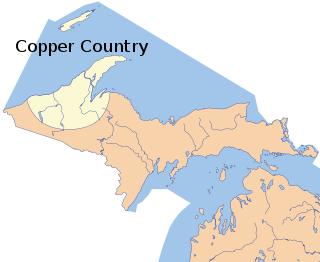
The Copper Country is an area in the Upper Peninsula of Michigan in the United States, including Keweenaw County, Michigan, Houghton, Baraga and Ontonagon counties as well as part of Marquette County. The area is so named as copper mining was prevalent there from 1845 until the late 1960s, with one mine continuing through 1995. In its heyday in the latter half of the 19th century and the early 20th century, the area was the world's greatest producer of copper.

<span class="mw-page-title-main">Quincy Mine</span> United States historic place

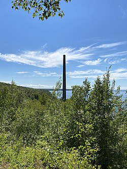
The Quincy Mine is an extensive set of copper mines located near Hancock, Michigan. The mine was owned by the Quincy Mining Company and operated between 1846 and 1945, although some activities continued through the 1970s. The Quincy Mine was known as "Old Reliable," as the Quincy Mine Company paid a dividend to investors every year from 1868 through 1920. The Quincy Mining Company Historic District is a United States National Historic Landmark District; other Quincy Mine properties nearby, including the Quincy Mining Company Stamp Mills, the Quincy Dredge Number Two, and the Quincy Smelter are also historically significant.

<span class="mw-page-title-main">Keweenaw National Historical Park</span> U.S. national historical park in Michigan

Keweenaw National Historical Park is a unit of the U.S. National Park Service. Established in 1992, the park celebrates the life and history of the Keweenaw Peninsula in the Upper Peninsula of the U.S. state of Michigan. As of 2009, it is a partly privatized park made up of two primary units, the Calumet Unit and the Quincy Unit, and 21 cooperating "Heritage Sites" located on federal, state, and privately owned land in and around the Keweenaw Peninsula. The National Park Service owns approximately 1,700 acres (690 ha) in the Calumet and Quincy Units. Units are located in Baraga, Houghton, Keweenaw, and Ontonagon counties.

<span class="mw-page-title-main">William A. Paine</span>

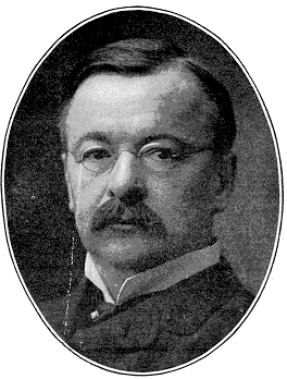
William Alfred Paine was an American businessman who co-founded the brokerage firm Paine Webber. He was also instrumental in the creation of the mining venture Copper Range Consolidated Company.

<span class="mw-page-title-main">National Register of Historic Places listings in Houghton County, Michigan</span>

This is a list of the National Register of Historic Places listings in Houghton County, Michigan.

<span class="mw-page-title-main">Calumet and Hecla Mining Company</span>

The Calumet and Hecla Mining Company was a major copper-mining company based within Michigan's Copper Country. In the 19th century, the company paid out more than $72 million in shareholder dividends, more than any other mining company in the United States during that period.

<span class="mw-page-title-main">White Pine, Michigan</span> Census-designated place & unincorporated community in Michigan, United States

White Pine is an unincorporated community and census-designated place (CDP) in Ontonagon County in the U.S. state of Michigan. The CDP had a population of 474 at the 2010 census. White Pine is located within Carp Lake Township.

<span class="mw-page-title-main">Kearsarge, Michigan</span> Unincorporated community in Michigan, United States

Kearsarge is an unincorporated community in Calumet Township, Houghton County in the U.S. state of Michigan. It is approximately 2 miles (3.2 km) northeast of Calumet/Laurium on U.S. Route 41/M-26 at 47°16′30″N88°24′58″W.

<span class="mw-page-title-main">Toivola, Michigan</span> Unincorporated community in Michigan, United States

Toivola is an unincorporated community in Houghton County, Michigan, United States. The far-flung rural community is divided between Stanton Township, Adams Township, and Bohemia Township. It is found along M-26, 8 miles (13 km) southwest of South Range, 16 miles (25.7 km) from Houghton, and 35 miles (56 km) from Ontonagon. Toivola has a post office with ZIP code 49965. The community's historic industries include mainly agrarian uses and lumbering.

<span class="mw-page-title-main">Quincy Smelter</span> Former copper smelter in Ripley, Michigan

The Quincy Smelter, also known as the Quincy Smelting Works, is a former copper smelter located on the north side of the Keweenaw Waterway in Ripley, Michigan. It is a contributing property of the Quincy Mining Company Historic District, a National Historic Landmark District. The smelter was built in 1898 by the Quincy Mining Company, operating from 1898 to 1931 and again from 1948 to 1971. The smelter was part of a Superfund site from 1986 to 2013.

The Michigan Smelter was a copper smelter located at Cole's Creek on the Keweenaw Waterway north-west of Houghton, Michigan near the old Atlantic mill. The smelter was created in 1903-4 as a joint effort between the Copper Range Company and Stanton group of mines. An Atlantic dam on the site was reused by the smelter as a water source. In 1905, the smelter broke a world record by casting 292,000 pounds of fine copper in seven hours with a single furnace and only ten men. The smelter operated through World War II and stopped all operations in 1948.

<span class="mw-page-title-main">Donken, Michigan</span> Unincorporated community in Michigan, United States

Donken is an unincorporated community in Houghton County, Michigan, United States. Donken is located in Elm River Township along M-26, 11.5 miles (18.5 km) southwest of South Range.

Clarence J. Monette was a prolific author and historian from Michigan's Copper Country, writing extensively on Copper Country history. He has published more than sixty books and has written numerous outdoor survival guides.

References

  1. 1 2 3 "Freda, Michigan". Geographic Names Information System . United States Geological Survey, United States Department of the Interior.
  2. "U.S. Census website". United States Census Bureau . Retrieved 2008-01-31.
  3. Lankton, Larry D. (2010). Hollowed Ground: Copper Mining and Community Building on Lake Superior, 1840s-1990s. Wayne State University Press. p. 148. ISBN   978-0814334904.
  4. Romig, Walter (1973). Michigan Place Names: The History of the Founding and the Naming of More Than Five Thousand Past and Present Michigan Communities. Wayne State University Press. p. 210. ISBN   9780814318386.
  5. Romig, Walter (1986) [1973]. Michigan Place Names. Detroit, Michigan: Wayne State University Press. ISBN   0-8143-1838-X.
  6. "Freda Post Office (historical)". Geographic Names Information System . United States Geological Survey, United States Department of the Interior.
  7. Daily Mining Gazette - 6/12/1912
  8. Daily Mining Gazette, 'Week' 8/22/1985
  9. Daily Mining Gazette - 8/28/1971

Further reading