Lake Linden, Michigan | |
---|---|
Coordinates: 47°11′43″N88°24′29″W / 47.19528°N 88.40806°W | |
Country | United States |
State | Michigan |
County | Houghton |
Townships | Schoolcraft and Torch Lake |
Government | |
• Type | Village council |
• President | Glenn Schuldt |
Area | |
• Total | 0.90 sq mi (2.34 km2) |
• Land | 0.79 sq mi (2.04 km2) |
• Water | 0.12 sq mi (0.30 km2) |
Elevation | 617 ft (188 m) |
Population (2020) | |
• Total | 1,014 |
• Density | 1,288.44/sq mi (497.30/km2) |
Time zone | UTC-5 (Eastern (EST)) |
• Summer (DST) | UTC-4 (EDT) |
ZIP code(s) | 49945 |
Area code | 906 |
FIPS code | 26-44780 [3] |
GNIS feature ID | 0630501 [2] |
Website | Official website |
Lake Linden is a village in Houghton County in the U.S. state of Michigan. The population was 1,007 at the 2010 census. The village is mostly within Schoolcraft Township, though a tiny portion lies in Torch Lake Township.
Lake Linden was named for an early settler. [4] A fire destroyed most of Lake Linden in 1887.
Lake Linden hosted minor league baseball from 1904 to 1906. The Lake Linden Lakers played as members of the Class C level Northern-Copper Country League and Copper Country Soo League. [5]
Lake Linden was the site of a large plant to process the copper ore of the Calumet and Hecla Mining Company. Calumet and Hecla shut down the operation in 1968.
A portion of the village was listed on the National Register of Historic Places as Lake Linden Historic District in 2009.
According to the United States Census Bureau, the village has a total area of 0.89 square miles (2.31 km2), of which 0.77 square miles (1.99 km2) is land and 0.12 square miles (0.31 km2) is water. [6]
Census | Pop. | Note | %± |
---|---|---|---|
1880 | 2,610 | — | |
1890 | 1,862 | −28.7% | |
1900 | 2,597 | 39.5% | |
1910 | 2,325 | −10.5% | |
1920 | 2,182 | −6.2% | |
1930 | 1,714 | −21.4% | |
1940 | 1,631 | −4.8% | |
1950 | 1,462 | −10.4% | |
1960 | 1,314 | −10.1% | |
1970 | 1,214 | −7.6% | |
1980 | 1,181 | −2.7% | |
1990 | 1,203 | 1.9% | |
2000 | 1,081 | −10.1% | |
2010 | 1,007 | −6.8% | |
2020 | 1,014 | 0.7% | |
U.S. Decennial Census [7] |
As of the census [8] of 2010, there were 1,007 people, 481 households, and 263 families living in the village. The population density was 1,307.8 inhabitants per square mile (504.9/km2). There were 568 housing units at an average density of 737.7 per square mile (284.8/km2). The racial makeup of the village was 97.4% White, 0.7% Native American, 0.2% Asian, 0.2% from other races, and 1.5% from two or more races. Hispanic or Latino of any race were 0.8% of the population.
There were 481 households, of which 24.5% had children under the age of 18 living with them, 36.8% were married couples living together, 13.3% had a female householder with no husband present, 4.6% had a male householder with no wife present, and 45.3% were non-families. 41.2% of all households were made up of individuals, and 20.8% had someone living alone who was 65 years of age or older. The average household size was 2.07 and the average family size was 2.78.
The median age in the village was 44.1 years. 21.4% of residents were under the age of 18; 7.4% were between the ages of 18 and 24; 22.8% were from 25 to 44; 25.4% were from 45 to 64; and 23.4% were 65 years of age or older. The gender makeup of the village was 51.0% male and 49.0% female.
As of the census [3] of 2000, there were 1,081 people, 485 households, and 307 families living in the village. The population density was 1,646.8 inhabitants per square mile (635.8/km2). There were 569 housing units at an average density of 866.8 per square mile (334.7/km2). The racial makeup of the village was 97.41% White, 0.09% African American, 0.65% Native American, 0.46% Asian, 0.19% from other races, and 1.20% from two or more races. Hispanic or Latino of any race were 0.93% of the population. 22.2% were of Finnish, 21.5% French, 14.3% French Canadian, 12.9% German, 9.0% English and 5.3% Italian ancestry according to Census 2000.
There were 485 households, out of which 26.4% had children under the age of 18 living with them, 48.9% were married couples living together, 11.5% had a female householder with no husband present, and 36.7% were non-families. 34.0% of all households were made up of individuals, and 19.0% had someone living alone who was 65 years of age or older. The average household size was 2.23 and the average family size was 2.84.
In the village, the population was spread out, with 23.6% under the age of 18, 6.5% from 18 to 24, 23.8% from 25 to 44, 24.9% from 45 to 64, and 21.3% who were 65 years of age or older. The median age was 42 years. For every 100 females, there were 92.3 males. For every 100 females age 18 and over, there were 84.4 males.
The median income for a household in the village was $24,234, and the median income for a family was $30,000. Males had a median income of $29,327 versus $18,654 for females. The per capita income for the village was $14,189. About 16.6% of families and 17.8% of the population were below the poverty line, including 20.1% of those under age 18 and 20.1% of those age 65 or over.
This climatic region is typified by large seasonal temperature differences, with warm to hot (and often humid) summers and cold (sometimes severely cold) winters. According to the Köppen Climate Classification system, Lake Linden has a humid continental climate, abbreviated "Dfb" on climate maps. [9]
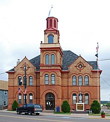
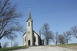
Calumet is a village in the Upper Peninsula of the U.S. state of Michigan. The village is located within Calumet Township, Houghton County, and had a population of 621 at the 2020 census.
Cedar Lake is a town in Hanover and Center townships, Lake County, Indiana, United States. It is near the Illinois state line. Its population was 11,560 at the 2010 census. The town is notable for its location on Cedar Lake, the Lake of the Red Cedars museum.
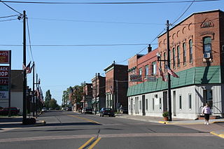
L'Anse is a village and the county seat of Baraga County, Michigan. The population was 1,874 at the 2020 census. The village is located within L'Anse Township in the Upper Peninsula, and partially inside the L'Anse Indian Reservation.
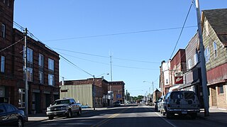
Laurium is a village in Calumet Township, Houghton County in the U.S. state of Michigan, in the center of the Keweenaw Peninsula. The population was 1,977 at the 2010 census.
Schoolcraft Township is a civil township of Houghton County in the U.S. state of Michigan. As of the 2020 census, the township had a population of 1,992. The township was organized in 1866.
Ahmeek is a village in Keweenaw County in the U.S. state of Michigan. The village is located within Allouez Township. The population was 127 at the 2020 census. At 0.07 square miles (0.18 km2), it is the smallest municipality in Michigan by land area, and is the only incorporated municipality in Keweenaw County.
Westmoreland is a town in Oneida County, New York, United States. The population was 6,138 at the 2010 census.
Bailey Lakes is a village in Clear Creek Township, Ashland County, Ohio, United States. The population was 349 at the 2020 census.
Wayne Lakes is a village in Darke County, Ohio, United States. The population was 693 at the 2020 census.
Lakeview is a village in Logan County, Ohio, United States. The population was 1,184 at the 2020 census.
Mount Pleasant Township is a township in Westmoreland County, Pennsylvania, United States. As of the 2020 census, the township population was 10,119. Mount Pleasant Township should not be confused with the Borough of Mount Pleasant, which is a separate municipality and comprises the town of that name.
Hecla is a city in Brown County, South Dakota, United States, located only a few miles south of the North Dakota border. The population was 193 at the 2020 census. State Highway 37 runs along the east side of town.
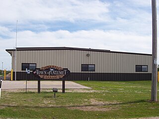
Charlestown is a town in Calumet County in the U.S. state of Wisconsin. The population was 775 at the 2010 census. The unincorporated community of Hayton is located in the town.
Hilbert is a village in Calumet County in the U.S. state of Wisconsin. The population was 1,132 at the 2010 census.
Woodville is a town in Calumet County in the U.S. state of Wisconsin. The population was 980 at the 2010 census. The unincorporated communities of Dundas and St. John are located in the community.
Calumet is a town in Fond du Lac County, Wisconsin, United States. The population was 1,514 at the 2000 census. The unincorporated communities of Artesia Beach, Calumet Harbor, Garnet, Highland Park, Johnsburg, Laudolff Beach, Marytown, Pipe, Pukwana Beach, Winnebago Heights, and Winnebago Park are located within the town. The unincorporated community of Calumetville is located partially in the town.
Woodville is a village in St. Croix County, Wisconsin, United States. The population was 1,344 at the 2010 census.
Buckeye Lake is a village in Fairfield and Licking counties in the U.S. state of Ohio. The population was 2,520 at the 2020 census. It is named for Buckeye Lake, a large lake along which the village is built.
Stockbridge is a town in Calumet County, Wisconsin. The population was 1,456 at the time of the 2010 census. The village of Stockbridge, and the unincorporated communities of Kloten, Quinney, and Saint Catherines Bay are located within the town.
Linden is a village in Iowa County, Wisconsin, United States. The population was 549 at the 2010 census. The village is located within the Town of Linden.