Hubbell, Michigan

Last updated

Hubbell, Michigan
Hubbell, MI location2.png
Location within Houghton County
USA Michigan location map.svg
Red pog.svg
Hubbell
Location within the state of Michigan
Usa edcp location map.svg
Red pog.svg
Hubbell
Hubbell (the United States)
Coordinates: 47°10′21″N88°25′58″W / 47.17250°N 88.43278°W / 47.17250; -88.43278
Country United States
State Michigan
County Houghton
Townships Torch Lake and Osceola
Area
[1]
  Total1.88 sq mi (4.86 km2)
  Land1.87 sq mi (4.84 km2)
  Water0.01 sq mi (0.03 km2)
Elevation
[2]
627 ft (191 m)
Population
 (2020)
  Total908
  Density486.34/sq mi (187.73/km2)
Time zone UTC-5 (Eastern (EST))
  Summer (DST) UTC-4 (EDT)
ZIP code(s)
49934
Area code 906
FIPS code 26-39680 [3]
GNIS feature ID0628746 [2]

Hubbell is an unincorporated community and census-designated place (CDP) in Houghton County in the U.S. state of Michigan. As of the 2020 census, the population was 908; down from 946 in the 2010 census [4] and down from 1,105 at the 2000 census. The community is partially within Torch Lake Township and partially within Osceola Township.

Contents

The community is on the west shore of Torch Lake on M-26, about 2 miles (3 km) southwest of the village of Lake Linden at 47°10′24″N88°25′45″W / 47.17333°N 88.42917°W / 47.17333; -88.42917 . The ZIP code is 49934 and the FIPS place code is 39680. It is named after Jay Abel Hubbell, a U.S. Representative (1873–1882) from the area.

Geography

According to the United States Census Bureau, the CDP has a total area of 1.9 square miles (4.9 km2), of which 0.01 square miles (0.03 km2), or 0.57%, are water. [4]

Demographics

Historical population
CensusPop.Note
2000 1,105
2010 946−14.4%
2020 908−4.0%
U.S. Decennial Census [5]

As of the census [3] of 2000, there were 1,105 people, 411 households, and 286 families residing in the CDP. The population density was 592.2 inhabitants per square mile (228.6/km2). There were 467 housing units at an average density of 250.3 per square mile (96.6/km2). The racial makeup of the CDP was 98.64% White, 0.09% Black or African American, 0.18% Native American, 0.09% Asian, 0.09% from other races, and 0.90% from two or more races. Hispanic or Latino of any race were 1.00% of the population. 23.7% were of Finnish, 18.4% French, 11.9% German, 10.9% French Canadian, 8.9% English and 6.9% Italian ancestry according to Census 2000.

There were 411 households, out of which 31.4% had children under the age of 18 living with them, 53.3% were married couples living together, 9.5% had a female householder with no husband present, and 30.4% were non-families. 25.5% of all households were made up of individuals, and 14.1% had someone living alone who was 65 years of age or older. The average household size was 2.48 and the average family size was 2.95.

In the CDP, the population was spread out, with 23.5% under the age of 18, 6.2% from 18 to 24, 27.5% from 25 to 44, 21.4% from 45 to 64, and 21.3% who were 65 years of age or older. The median age was 41 years. For every 100 females, there were 87.3 males. For every 100 females age 18 and over, there were 84.9 males.

The median income for a household in the CDP was $29,612, and the median income for a family was $35,481. Males had a median income of $28,750 versus $25,781 for females. The per capita income for the CDP was $19,260. About 10.5% of families and 13.1% of the population were below the poverty line, including 21.1% of those under age 18 and 12.2% of those age 65 or over.

Climate

This climatic region is typified by wide seasonal temperature variance, with warm to hot (and often humid) summers and cold (sometimes severely cold) winters with large amounts of snowfall. According to the Köppen Climate Classification system, Hubbell has a humid continental climate, abbreviated "Dfb" on climate maps. [6]

Related Research Articles

<span class="mw-page-title-main">Oscoda, Michigan</span> Census-designated place & unincorporated community in Michigan, United States

Oscoda is an unincorporated community and census-designated place (CDP) in Iosco County in the U.S. state of Michigan. The CDP had a population of 916 at the 2020 census. The community is located within Au Sable Township and Oscoda Township at the mouth of the Au Sable River along Lake Huron.

<span class="mw-page-title-main">Tillmans Corner, Alabama</span> Unincorporated community in Alabama, United States

Tillmans Corner, or Tillman’s Corner, is an unincorporated community and census-designated place (CDP) in Mobile County, Alabama, United States. At the 2020 census, the population was 17,731. It is part of the Mobile metropolitan area, and is the largest census-designated place in Alabama.

Lake Arrowhead is a census-designated place (CDP) in the towns of Waterboro and Limerick in York County, Maine, United States. The population was 3,071 at the 2010 census. The CDP corresponds to the area covered by the Lake Arrowhead Community, a large subdivision begun in the 1960s which surrounds Lake Arrowhead, an artificial lake on the Little Ossipee River. The community is part of the Portland–South Portland–Biddeford, Maine Metropolitan Statistical Area.

<span class="mw-page-title-main">Springvale, Maine</span> Place in Maine, United States

Springvale is a village and former census-designated place in the city of Sanford in York County, Maine, United States. The population was 3,292 at the 2010 census. It is part of the Portland–South Portland–Biddeford, Maine metropolitan statistical area. The CDP was abolished when the town of Sanford reincorporated as a city.

<span class="mw-page-title-main">Perryman, Maryland</span> Census-designated place in Maryland, United States

Perryman is an unincorporated community and census-designated place (CDP) in Harford County, Maryland, United States. The population was 2,342 at the 2010 census.

<span class="mw-page-title-main">Grand Island Township, Michigan</span> Civil township in Michigan, United States

Grand Island Township is a civil township of Alger County in the U.S. state of Michigan.

<span class="mw-page-title-main">Greilickville, Michigan</span> Census-designated place & unincorporated community in Michigan, United States

Greilickville is an unincorporated community and census-designated place (CDP) in Leelanau County in the U.S. state of Michigan. At the 2020 census, the population was 1,634, up from 1,530 at the 2010 census. The community is located within Elmwood Charter Township, and is located in the extreme southeast of the Leelanau Peninsula.

<span class="mw-page-title-main">Atlanta, Michigan</span> Census-designated place in Michigan, United States

Atlanta is a census-designated place and unincorporated community in the U.S. state of Michigan. It is the county seat of Montmorency County. The community had a population of 720 at the 2020 census, down from 827 in 2010. Atlanta has been nicknamed the "Elk Capital of Michigan".

<span class="mw-page-title-main">Freeland, Michigan</span> Census-designated place & unincorporated community in Michigan, United States

Freeland is a census-designated place in Tittabawassee Township, Saginaw County in the U.S. state of Michigan. It is part of the Saginaw-Midland-Bay Metropolitan Area. As of the 2000 census, the CDP population was 5,147. The CDP covers an area in the central portion of Tittabawassee Township. The Freeland post office, ZIP code 48623, serves nearly the entire township, as well as portions of Midland and Williams townships to the north, Frankenlust and Kochville townships to the east, Thomas and Richland townships to the south, and Ingersoll Township to the west.

<span class="mw-page-title-main">Lonepine, Montana</span> CDP in Montana, United States

Lonepine is a census-designated place (CDP) in Sanders County, Montana, United States. The population was 137 at the 2000 census.

<span class="mw-page-title-main">Shark River Hills, New Jersey</span> Populated place in Monmouth County, New Jersey, US

Shark River Hills is an unincorporated community and census-designated place (CDP) within Neptune Township, in Monmouth County, in the U.S. state of New Jersey. As of the 2010 United States Census, the CDP's population was 3,697.

<span class="mw-page-title-main">Aquebogue, New York</span> Hamlet and census-designated place in New York, United States

Aquebogue is a census-designated place (CDP) roughly corresponding to the hamlet by the same name in the Town of Riverhead in Suffolk County, on Long Island, in New York, United States. The CDP's population was 2,438 at the 2010 census.

<span class="mw-page-title-main">Lucerne Mines, Pennsylvania</span> Census-designated place in Pennsylvania, United States

Lucernemines, usually written as Lucerne Mines, is a census-designated place (CDP) in Indiana County, Pennsylvania, United States. The population was 937 at the 2010 census.

<span class="mw-page-title-main">Normanna, Texas</span> Census-designated place in Texas, United States

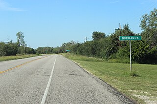
Normanna is a census-designated place in Bee County, Texas, United States. The population was 113 at the 2010 census.

<span class="mw-page-title-main">Stonewall, Texas</span> Census-designated place in Texas, United States

Stonewall is an unincorporated community and census-designated place (CDP) in Gillespie County, Texas, United States. The population was 525 at the 2010 census. It was named for Confederate General Thomas J. (Stonewall) Jackson, by Israel P. Nunez, who established a stage station near the site in 1870.

<span class="mw-page-title-main">Knippa, Texas</span> Census-designated place in Texas, United States

Knippa is a census-designated place (CDP) in Uvalde County, Texas, United States. The population was 689 at the 2010 census.

<span class="mw-page-title-main">Jolivue, Virginia</span> Census-designated place in Virginia, United States

Jolivue is a census-designated place (CDP) in Augusta County, Virginia, United States. The population was 1,129 at the 2010 census. It is part of the Staunton–Waynesboro Micropolitan Statistical Area.

<span class="mw-page-title-main">Cross Lanes, West Virginia</span> Census-designated place in West Virginia, United States

Cross Lanes is a census-designated place (CDP) and suburb of Charleston in Kanawha County, West Virginia, United States. As of the 2010 census, its population was 9,995.

<span class="mw-page-title-main">Horseshoe Bay, Texas</span> City in Texas, United States

Horseshoe Bay is a city in Llano and Burnet counties in the U.S. state of Texas.

Hollins is a census-designated place (CDP) in Botetourt and Roanoke County, Virginia, United States. Hollins covers much of the area known locally as "North County". The population was 15,574 at the 2020 census. It is part of the Roanoke Metropolitan Statistical Area. The area is also the home of Hollins University in addition to four properties listed on the National Register of Historic Places: the Black Horse Tavern-Bellvue Hotel and Office, Harshbarger House, the Hollins College Quadrangle, and Old Tombstone.

References

  1. "2020 U.S. Gazetteer Files". United States Census Bureau. Retrieved May 21, 2022.
  2. 1 2 U.S. Geological Survey Geographic Names Information System: Hubbell, Michigan
  3. 1 2 "U.S. Census website". United States Census Bureau . Retrieved January 31, 2008.
  4. 1 2 "Geographic Identifiers: 2010 Census Summary File 1 (G001): Hubbell CDP, Michigan". American Factfinder. U.S. Census Bureau. Archived from the original on February 13, 2020. Retrieved August 11, 2017.
  5. "Census of Population and Housing". Census.gov. Retrieved June 4, 2016.
  6. Climate Summary for Hubbell, Michigan