Stanton Township, Michigan

Last updated
Stanton Township, Michigan
Stanton Township, MI location2.png
Location within Houghton County
USA Michigan location map.svg
Red pog.svg
Stanton Township
Location within the state of Michigan
Usa edcp location map.svg
Red pog.svg
Stanton Township
Stanton Township (the United States)
Coordinates: 47°04′54″N88°47′22″W / 47.08167°N 88.78944°W / 47.08167; -88.78944 Coordinates: 47°04′54″N88°47′22″W / 47.08167°N 88.78944°W / 47.08167; -88.78944
Country United States
State Michigan
County Houghton
Established1902
Government
  SupervisorMarvin Heinonen
Area
  Total123.6 sq mi (320.0 km2)
  Land122.3 sq mi (316.8 km2)
  Water1.2 sq mi (3.2 km2)
Elevation
863 ft (263 m)
Population
 (2000)
  Total1,268
  Density10.4/sq mi (4.0/km2)
Time zone UTC-5 (Eastern (EST))
  Summer (DST) UTC-4 (EDT)
ZIP code(s)
49905 (Atlantic Mine)
49931 (Houghton)
49965 (Toivola)
Area code(s) 906
FIPS code 26-76200 [1]
GNIS feature ID1627121 [2]
Website Official website

Stanton Township is a civil township of Houghton County in the U.S. state of Michigan. The population was 1,268 at the 2000 census. Stanton Township has the distinction of having, at 47%, the highest concentration of people with Finnish ancestry of any place in the United States. [3]

Contents

Geography

According to the United States Census Bureau, the township has a total area of 123.6 square miles (320 km2), of which 122.3 square miles (317 km2) is land and 1.2 square miles (3.1 km2) (1.00%) is water.

Communities

Parks

Demographics

Largest ancestries (2000)Percent
Finnish Flag of Finland.svg 46.9%
German Flag of Germany.svg 10.9%
English Flag of England.svg 8.4%
Irish Flag of Ireland.svg 6.3%
French Flag of France.svg 4.8%
Swedish Flag of Sweden.svg 4.0%
American Flag of the United States.svg 2.9%
Norwegian Flag of Norway.svg 2.5%
Languages (2000) [13] [14] Percent
Spoke only English at home81.99%
Spoke Finnish at home6.40%
Spoke German at home0.88%
Spoke Spanish at home0.70%
Spoke English "not well" or "not at all."0.76%

As of the census [1] of 2000, there were 1,268 people, 475 households, and 315 families residing in the township. The population density was 10.4 per square mile (4.0/km2). There were 695 housing units at an average density of 5.7 per square mile (2.2/km2). The racial makeup of the township was 98.19% White, 0.24% African American, 0.55% Native American, and 1.03% from two or more races. Hispanic or Latino of any race were 0.55% of the population. Some 46.9% of Stanton Township residents report Finnish ancestry, the highest such percentage in the United States.

There were 475 households, out of which 29.9% had children under the age of 18 living with them, 56.4% were married couples living together, 6.7% had a female householder with no husband present, and 33.5% were non-families. 28.4% of all households were made up of individuals, and 9.3% had someone living alone who was 65 years of age or older. The average household size was 2.67 and the average family size was 3.36.

In the township the population was spread out, with 30.1% under the age of 18, 8.2% from 18 to 24, 22.6% from 25 to 44, 25.4% from 45 to 64, and 13.6% who were 65 years of age or older. The median age was 38 years. For every 100 females, there were 111.3 males. For every 100 females age 18 and over, there were 120.4 males.

The median income for a household in the township was $38,200, and the median income for a family was $41,771. Males had a median income of $35,455 versus $26,875 for females. The per capita income for the township was $16,338. About 5.1% of families and 7.1% of the population were below the poverty line, including 7.1% of those under age 18 and 4.3% of those age 65 or over.

Related Research Articles

Baraga Township, Michigan Civil township in Michigan, United States

Baraga Township is a civil township of Baraga County in the U.S. state of Michigan. As of the 2010 census, the township population was 3,815. The village of Baraga is located in the southeast corner of the township.

LAnse Township, Michigan Civil township in Michigan, United States

L'Anse Township is a civil township of Baraga County in the U.S. state of Michigan. As of the 2010 census, the township population was 3,843. Mount Arvon and Mount Curwood, the highest and second highest points in Michigan, are located in the township.

Spurr Township, Michigan Civil township in Michigan, United States

Spurr Township is a civil township of Baraga County in the U.S. state of Michigan. The population was 276 at the 2010 census.

Sunfield Township is a civil township of Eaton County in the U.S. state of Michigan. The population was 2,177 at the 2000 census.

Adams Township, Houghton County, Michigan Civil township in Michigan, United States

Adams Township is a civil township of Houghton County in the U.S. state of Michigan. As of the 2000 census, the township population was 2,747.

Calumet Charter Township, Michigan Charter township in Michigan, United States

Calumet Charter Township is a charter township of Houghton County in the U.S. state of Michigan. The population was 6,263 at the 2020 census. Even with a decreasing population, the township remains the largest township by population in Houghton County.

Franklin Township, Houghton County, Michigan Civil township in Michigan, United States

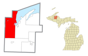
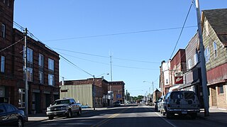
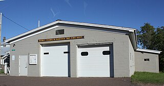
Franklin Township is a civil township of Houghton County in the U.S. state of Michigan. The population was 1,320 at the 2000 census.

Laird Township, Michigan Civil township in Michigan, United States

Laird Township is a civil township of Houghton County in the U.S. state of Michigan. The population was 634 at the 2000 census.

Laurium, Michigan Village in Michigan, United States

Laurium is a village in Calumet Township, Houghton County in the U.S. state of Michigan, in the center of the Keweenaw Peninsula. The population was 1,977 at the 2010 census.

Portage Charter Township, Michigan Charter township in Michigan, United States

Portage Charter Township is a charter township of Houghton County in the U.S. state of Michigan. As of the 2010 census, the township population was 3,221. The city of Houghton is adjacent to the north side of the township. Portage Lake is the eastern boundary in the north, and the township extends well south of Houghton to the Baraga County line.

Quincy Township, Houghton County, Michigan Civil township in Michigan, United States

Quincy Township is a civil township of Houghton County in the U.S. state of Michigan. As of the 2000 census, the township population was 251.

South Range, Michigan Village in Michigan, United States

South Range is a village in Adams Township, Houghton County in the U.S. state of Michigan. It is bordered on the east by the unincorporated community of Baltic. It is about five miles southwest of Houghton on M-26. The population was 758 at the 2010 census. The ZIP code for South Range is 49963.

Torch Lake Township, Houghton County, Michigan Civil township in Michigan, United States

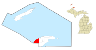
Torch Lake Township is a civil township of Houghton County in the U.S. state of Michigan. As of the 2010 census, the population of the township was 1,880. The township was established in 1886 and is one of the largest townships in Houghton County by area. It is surrounded by the Torch Lake, the Portage Lake, and Lake Superior. As well as a large number of unincorporated communities, the township also includes a portion of the Baraga State Forest which lies along the shores of Keweenaw Bay. The township borders Schoolcraft Township to the north, Osceola Township to the northwest, and Chassell Township to the southwest. The community of Hubbell serves as the major population center of the township, as well as hosting the Township Hall itself. The mostly uninhabited 91-acre Rabbit Island, located offshore in Lake Superior, is a part of the township.

Allouez Township, Michigan Civil township in Michigan, United States

Allouez Township is a civil township of Keweenaw County in the U.S. state of Michigan. As of the 2020 census, the township population was 1,428.

Eagle Harbor Township, Michigan Civil township in Michigan, United States

Eagle Harbor Township is a civil township of Keweenaw County in the U.S. state of Michigan. As of the 2020 census, the township population was 217. The irregularly shaped township is located on the Keweenaw Peninsula and also includes the southwestern half of Isle Royale. The unincorporated community of Eagle Harbor is located in the township along Lake Superior on M-26.

Houghton Township, Michigan Civil township in Michigan, United States

Houghton Township is a civil township of Keweenaw County in the U.S. state of Michigan. The township consists of a portion of the Keweenaw Peninsula and also the northeastern half of Isle Royale, which makes it the northernmost municipality in the state of Michigan. The population was 72 at the 2020 census, which makes it the third-least densely populated municipality in the state.

Skandia Township, Michigan Civil township in Michigan, United States

Skandia Township is a civil township of Marquette County in the U.S. state of Michigan. The population was 826 at the 2010 census. The township contains the Dukes Research Natural Area, a National Natural Landmark.

Douglass Township is a civil township of Montcalm County in the U.S. state of Michigan. The population was 2,377 at the 2000 census.

Montcalm Township is a civil township of Montcalm County in the U.S. state of Michigan. The population was 3,178 at the 2000 census.

Sidney Township is a civil township of Montcalm County in the U.S. state of Michigan. The population was 2,563 at the 2000 census.

References

  1. 1 2 "U.S. Census website". United States Census Bureau . Retrieved 2008-01-31.
  2. "Stanton Township, Michigan". Geographic Names Information System . United States Geological Survey.
  3. U.S. census data as compiled by eopdunk.com
  4. "Beacon Hill, Michigan". Geographic Names Information System . United States Geological Survey.
  5. 1 2 Romig, Walter (1986) [1973]. Michigan Place Names. Detroit, Michigan: Wayne State University Press. ISBN   0-8143-1838-X.
  6. "Beacon Hill Post Office (historical)". Geographic Names Information System . United States Geological Survey.
  7. Romig, Michigan Place Names, p. 137
  8. 1 2 3 4 5 6 7 8 Monette, Clarence (1975). Some Copper Country Names and Places. Lake Linden. ISBN   0-942363-04-3.
  9. Ilmonen, S. (1926). AMERIKAN SUOMALAISIA HISTORIA III; YHDYSVALLOISSA JA CANADASSA OLEVAT SUOMALAISET ASUTUKSET[American history of Finnish III; Finnish settlement in the United States and Canada] (in Finnish). Suomalais-Luteerilainen Kustannusliike. p. 113. ASIN   B00AGY26I4.
  10. "Oskar, Michigan". Geographic Names Information System . United States Geological Survey.
  11. "Oskar Post Office (historical)". Geographic Names Information System . United States Geological Survey.
  12. History information on the Stanton Township webpage http://www.stantontownship.com/wp-content/uploads/2009/12/1.-Redridge-description.pdf
  13. "Data Center Results".
  14. "Data Center Results".