
Upshur County is a county in the U.S. state of West Virginia. As of the 2010 census, the population was 24,254. Its county seat is Buckhannon. The county was formed in 1851 from Randolph, Barbour, and Lewis counties and named for Abel Parker Upshur, a distinguished statesman and jurist of Virginia. Upshur served as United States Secretary of State and Secretary of the Navy under President John Tyler.

Buckhannon is the only incorporated city in, and the county seat of, Upshur County, West Virginia, United States, and is located along the Buckhannon River. The population was 5,639 at the 2010 census. The city is located 60 miles southwest of Morgantown, 115 miles northeast of the capital city of Charleston, 140 miles south of Pittsburgh, Pennsylvania, and 260 miles west of Washington, D.C.. Buckhannon is home to West Virginia Wesleyan College and the West Virginia Strawberry Festival, held annually during the third week of May.

Burlington is a census-designated place (CDP) in Mineral County, West Virginia located along U.S. Route 50 where it crosses Pattersons Creek. As of the 2010 census, its population was 182. It is part of the Cumberland, MD-WV Metropolitan Statistical Area. The ZIP code for Burlington is 26710.
Huntersville is a census-designated place (CDP) located in Pocahontas County, West Virginia in the Alleghany Mountains. As of the 2010 census, its population was 73. It is located six miles east of Marlinton and four miles west of Minnehaha Springs. Huntersville received its name because it was a rendezvous for trappers and hunters who came to trade pelts for supplies. It served as the county seat of Pocahontas County until 1891 when the county's residents voted to move the seat to Marlinton. A local newspaper called "The Pocahontas Times" is distributed in the area.
Rock Cave is an unincorporated community in Upshur County, West Virginia, United States. The town is located southwest of Buckhannon at the junction of West Virginia Route 4 with County Routes 11/2 and 20/28.

Sago is an unincorporated community in Upshur County, West virginia, United States. It is located along the Buckhannon River and is the site of the Sago Mine, scene of the 2006 Sago Mine disaster.
Selbyville is an unincorporated community along the Right Fork Buckhannon River in Upshur County, West Virginia, United States.

Tomahawk is an unincorporated community on Back Creek in Berkeley County, West Virginia. The community is named for a nearby series of springs in the shape of a tomahawk. The community includes the historic Tomahawk Presbyterian Church, established c. 1745, and its adjacent community cemetery, which has gravestones dating to the late 18th century. The community lies 9.5 miles from Martinsburg.

George Robert Latham was a 19th-century Virginia farmer, lawyer and politician who helped found the state of West Virginia during the American Civil War, during which he served as a colonel in the Union Army. He later served one term in the United States House of Representatives representing West Virginia's 2nd congressional district (1864-1866), as well as became U.S. Consul in Melbourne, Australia (1867-1870) before returning to West Virginia to farm and hold various civic offices.

Delaplane is an unincorporated community in northern Fauquier County, Virginia, approximately 50 miles (80 km) due west of Washington, D.C. Delaplane is situated along U.S. Route 17, U.S. Route 50, and Interstate 66; bordering Upperville, Virginia to the north, Hume, Virginia to the south, Paris, Virginia to the west, and Rectortown, Virginia to the east. Delaplane, Virginia has a ZIP Code of 20144.

The West Virginia State Wildlife Center is a zoological park in French Creek, West Virginia. Operated by the West Virginia Division of Natural Resources, the Wildlife Center displays many of West Virginia's wildlife, including both native and introduced species. A few of the animals at the Wildlife Center were once found naturally in West Virginia, but were extirpated by the early 1900s.

French Creek Presbyterian Church is a historic Presbyterian church located in French Creek, Upshur County, West Virginia. It was built in 1866 by settlers from New England, and is a simple rectangular frame building with a white weatherboard exterior. It measures 50 feet by 40 feet and has a gable roof topped by a belfry.
Frenchton is an unincorporated community in Upshur County, West Virginia, United States. Frenchton is 10.5 miles (16.9 km) southwest of Buckhannon. Frenchton has a post office with ZIP code 26219.
Kanawha Head is an unincorporated community in Upshur County, West Virginia, United States. Kanawha Head is located on West Virginia Route 20, 16.5 miles (26.6 km) south-southwest of Buckhannon. Kanawha Head had a post office with ZIP code 26228.
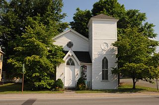
The Southern Methodist Church Building, now known and used as the Upshur County Historical Society's History Center Museum, is an historic former church building located at 81 W. Main Street in Buckhannon, Upshur County, West Virginia. It was built in 1856 with final modifications in the 1890s, and is a simple rectangular frame building. The original structure measures 45 feet by 33 feet in the Greek Revival style. In 1891, a 9 feet by 14 feet vestibule was added, along with a three-story bell tower. In 1968, it was sold to the Church of Christ and then sold to the Upshur County Historical Society in 1986.

Agnes Howard Hall, also known as Ladies Hall or "Aggie," is a historic dormitory building located on the campus of West Virginia Wesleyan College at Buckhannon, Upshur County, West Virginia. It was built in 1895, and is a five-story brick building primarily used as a residence hall. It features an eclectic design with three tower caps and multiple hip roofs. An addition was completed in 1929 and extensive renovations occurred in 1952. It contains 77 sleeping rooms and 26 main bathrooms, along with office areas for residence assistants, lounge areas, kitchen facilities, and maintenance storage rooms. It was the first dormitory constructed at West Virginia Wesleyan College and the oldest on campus. It was officially named Agnes Howard Hall in 1920, in memory of a young coed who had died while a student at Wesleyan.
Downtown Buckhannon Historic District is a national historic district located at Buckhannon, Upshur County, West Virginia. It encompasses 57 contributing buildings and one contributing structure that include the civic and commercial core of Buckhannon. Most of the buildings in the district date from the late-19th and early-20th century in popular architectural styles, such as Italianate, Queen Anne, Colonial Revival, and Classical Revival. Notable buildings include the Presbyterian Church on Locust Street (1879), T. L. Stockert Building (1908), Peoples Bank Building (1910), Upshur County Court House, and U.S. Post Office (1916).
Alexander is an unincorporated community in Upshur County, West Virginia, United States. Alexander is located on County Route 11 and the Buckhannon River, 14.6 miles (23.5 km) south of Buckhannon. The coal hauling Beech Mountain Railroad (BEEM) also runs through and interchanges with the Appalachian and Ohio Railroad (A&O) in Alexander.

Clover Creek is an unincorporated community in Highland County, Virginia, United States. Clover Creek is located 10 miles (16 km) south-southeast of Monterey, Virginia on State Route 678. The community is situated in the Bullpasture Valley along the path of the Bullpasture River. Beginning in 1897 with a decision by the United States Board on Geographic Names, the community was officially referred to as the single-word "Clovercreek"; however, in 1970, the board modified the community's name to the current two-word "Clover Creek". During the French and Indian War, a British fort named Fort George was built near Clover Creek in 1754 consisting of a wooden stockade 90 feet (27 m) square. The fort was never directly attacked, though arrows were at one point launched against the fort from a distance leaving no damage. George Washington may have visited the fort while traveling in the area, marking the only time Washington visited the region which is now known as Highland County.
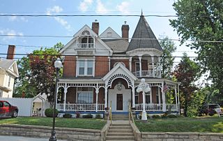
Buckhannon Central Residential Historic District is a national historic district located at Buckhannon, Upshur County, West Virginia. The district encompasses 344 contributing buildings, 2 contributing sites, 11 contributing structures, and 2 contributing objects in Buckhannon. It consists of primarily single family residential homes dating from the mid-19th through mid-20th century. They are in variety of popular architectural styles including Greek Revival, Gothic Revival, Late Victorian, Colonial Revival, Tudor Revival, and Bungalow. Notable contributing resources include historic brick sidewalks, Works Progress Administration sidewalks and logos, Jawbone Park, the Charles Gibson City Library building, the Liberty in Christ Church (1873), First United Methodist Church (1910), the First Baptist Church, the African Methodist Episcopal (AME) Church (1919), Victoria or Central School, and 79 East Main Street (1909).


