
Upshur County is a county in the U.S. state of West Virginia. As of the 2020 census, the population was 23,816. Its county seat is Buckhannon. The county was formed in 1851 from Randolph, Barbour, and Lewis counties and named for Abel Parker Upshur, a distinguished statesman and jurist of Virginia. Upshur served as United States Secretary of State and Secretary of the Navy under President John Tyler.

Buckhannon is the only incorporated city in, and the county seat of, Upshur County, West Virginia, United States, and is located along the Buckhannon River. The population was 5,299 at the 2020 census. The city is located 60 miles southwest of Morgantown, 115 miles northeast of the capital city of Charleston, 140 miles south of Pittsburgh, Pennsylvania, and 220 miles west of Washington, D.C. Buckhannon is home to West Virginia Wesleyan College and the West Virginia Strawberry Festival, held annually during the third week of May. In 2023, Buckhannon will host The World Association of Marching Show Bands.

Abel Parker Upshur was a lawyer, planter, slaveowner, judge and politician from the Eastern Shore of Virginia. Active in Virginia state politics for decades, with a brother and a nephew who became distinguished U.S. Navy officers, Judge Upshur left the Virginia bench to become the Secretary of the Navy and Secretary of State during the administration of President John Tyler, a fellow Virginian. He negotiated the treaty that led to the 1845 Texas annexation to the United States and helped ensure that it was admitted as a slave state. Upshur died on February 28, 1844, when a gun on the warship USS Princeton exploded during a demonstration.
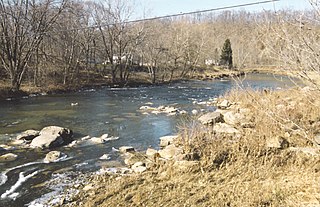
The Buckhannon River is a 45.4-mile-long (73.1 km) tributary of the Tygart Valley River in north-central West Virginia, USA. Via the Tygart Valley, Monongahela and Ohio rivers, it is part of the watershed of the Mississippi River, draining an area of 309 square miles (800 km2) on the unglaciated portion of the Allegheny Plateau. It provides drinking water for much of Upshur County.
Czar is an unincorporated community in Randolph County, West Virginia, United States, near the Upshur County line.
Rock Cave is an unincorporated community in Upshur County, West Virginia, United States. The town is located southwest of Buckhannon at the junction of West Virginia Route 4 with County Routes 11/2 and 20/28.

Sago is an unincorporated community in Upshur County, West Virginia, United States. It is located along the Buckhannon River and is the site of the Sago Mine, scene of the 2006 Sago Mine disaster.
Arlington is an unincorporated community along the Little Kanawha River in Upshur County, West Virginia, United States. Alfious Arlington Fidler, an early postmaster, gave the town his middle name. Its nineteenth century Fidler's Mill is listed on the National Register of Historic Places. Arlington is located south of Rock Cave.
French Creek is an unincorporated community in Upshur County, West Virginia, United States.
Buckhannon-Upshur High School (B-UHS) is a high school located in Buckhannon, West Virginia, United States with approximately 1,100 students. It is located at 270 B-U Drive, about two miles south of Buckhannon city limits. The school offers grades 9-12, and serves all of Upshur County with some students from surrounding counties. Mr. Randy West serves as principal of Buckhannon-Upshur High School.

This is a list of the National Register of Historic Places listings in Upshur County, West Virginia.
Alexander is an unincorporated community in Upshur County, West Virginia, United States. Alexander is located on County Route 11 and the Buckhannon River, 14.6 miles (23.5 km) south of Buckhannon. The coal hauling Beech Mountain Railroad (BEEM) also runs through and interchanges with the Appalachian and Ohio Railroad (A&O) in Alexander.
Abbott is an unincorporated community in Upshur County, West Virginia, United States.
Imperial is an unincorporated community in Upshur County, West Virginia, United States.
Kedron is an unincorporated community in Upshur County, West Virginia, United States.
Tenmile is an unincorporated community in Upshur County, West Virginia, United States.
Queens is an unincorporated community in Upshur County, West Virginia, United States.
Gaines is an unincorporated community in Upshur County, West Virginia, United States.
Hinkleville is an unincorporated community in Upshur County, West Virginia, United States.
Hodgesville is an unincorporated community in Upshur County, West Virginia, United States. It is a crossroads community, at the place where WV Route 20 intersects with Hacker's Creek Road heading west, and Teter Road heading east.


