
A swamp is a forested wetland. Swamps are considered to be transition zones because both land and water play a role in creating this environment. Swamps vary in size and are located all around the world. The water of a swamp may be fresh water, brackish water, or seawater. Freshwater swamps form along large rivers or lakes where they are critically dependent upon rainwater and seasonal flooding to maintain natural water level fluctuations. Saltwater swamps are found along tropical and subtropical coastlines. Some swamps have hammocks, or dry-land protrusions, covered by aquatic vegetation, or vegetation that tolerates periodic inundation or soil saturation. The two main types of swamp are "true" or swamp forests and "transitional" or shrub swamps. In the boreal regions of Canada, the word swamp is colloquially used for what is more correctly termed a bog, fen, or muskeg. Some of the world's largest swamps are found along major rivers such as the Amazon, the Mississippi, and the Congo.

The Monongahela National Forest is a national forest located in the Allegheny Mountains of eastern West Virginia, USA. It protects over 921,000 acres of federally owned land within a 1,700,000 acres proclamation boundary that includes much of the Potomac Highlands Region and portions of 10 counties.

The Great Dismal Swamp National Wildlife Refuge was created in 1974 to help protect and preserve a portion of the Great Dismal Swamp, a marshy region on the Coastal Plain of southeastern Virginia and northeastern North Carolina between Norfolk, Virginia, and Elizabeth City, North Carolina in the United States. It is located in parts of the independent cities of Chesapeake and Suffolk in Virginia, and the counties of Camden, Gates, and Pasquotank in North Carolina.

The National Register of Historic Places in the United States is a register including buildings, sites, structures, districts, and objects. The Register automatically includes all National Historic Landmarks as well as all historic areas administered by the U.S. National Park Service. Since its introduction in 1966, more than 90,000 separate listings have been added to the register.

The Okefenokee National Wildlife Refuge is a 402,000‑acre (1,627 km2) National Wildlife Refuge located in Charlton, Ware, and Clinch Counties of Georgia, and Baker County in Florida, United States. The refuge is administered from offices in Folkston, Georgia. The refuge was established in 1937 to protect a majority of the 438,000 acre (1,772 km2) Okefenokee Swamp. The name "Okefenokee" is a Native American word meaning "trembling earth."
Cedar Creek is a 40.5-mile-long (65.2 km) tributary stream of the North Fork Shenandoah River in northern Virginia in the United States. It forms the majority of the boundary between Frederick and Shenandoah counties. Cedar Creek's confluence with the North Fork Shenandoah is located at Strasburg.

The Blackwater River of southeastern Virginia flows from its source near the city of Petersburg, Virginia for about 105 miles (170 km) through the Inner Coastal Plain region of Virginia. The Blackwater joins the Nottoway River to form the Chowan River, which empties into Albemarle Sound. The Blackwater-Nottoway confluence forms the boundary between Virginia and North Carolina.

Potomac Creek is a 16.7-mile-long (26.9 km) tidal tributary of the Potomac River in King George and Stafford counties, Virginia. Potomac Creek's source lies between the communities of Glendie and Paynes Corner in Stafford County. It empties into the Potomac River at Marlboro Point. Potomac Creek forms as a dam to form Abel Lake.

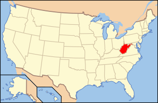
West Virginia's geologic history stretches back into the Precambrian, and includes several periods of mountain building and erosion. At times, much of what is now West Virginia was covered by swamps, marshlands, and shallow seas, accounting for the wide variety of sedimentary rocks found in the state, as well as its wealth of coal and natural gas deposits. West Virginia has had no active volcanism for hundreds of millions of years, and does not experience large earthquakes, although smaller tremors are associated with the Rome Trough, which passes through the western part of the state.
Dragon Run State Forest is a Virginia state forest located in King and Queen County. 1,811 acres (7.33 km2) in size, it protects the Dragon Run Swamp while allowing for forest management. Hunting is permitted on the forest grounds.

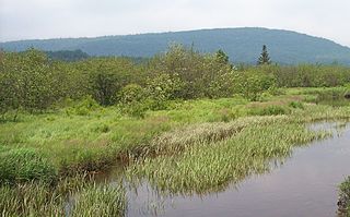
Cranesville Swamp Preserve is a 1,600-acre (650 ha) preserve situated in Preston County, West Virginia and Garrett County, Maryland. It is one of the few remaining boreal bogs in the southern United States, unusual in harboring many plants and animals that are normally only seen in more northern climates.
Shrub swamps — also called scrub swamps or buttonbush swamps — are a type of freshwater wetland ecosystem occurring in areas too wet to become swamps, but too dry or too shallow to become marshes. They are often considered transitional (“mid-successional”) between wet meadows or fens and conifer or hardwood swamps.
The Dragon Run watershed in the U.S. state of Virginia encompasses 140 square miles (360 km2) and is home to many flora and fauna species. The brackish water stream, labeled on topographic maps as Dragon Swamp, is fed by underground springs, surface runoff, and numerous feeding swamps. In a study of 232 rivers and streams in the Chesapeake Bay, the Nature Conservancy and the Chesapeake Bay Foundation found the Dragon Run to rank second in terms of ecological significance. Efforts are being made to preserve the Dragon Run, including Governor Tim Kaine’s large purchase of land in order to maintain and protect the watershed’s original state.

Elections were held in West Virginia on November 2, 2010. Primary elections took place on May 11, 2010.

Zekiah Swamp is part of the Potomac River basin in Charles County, Maryland in the United States. The swamp is 21 miles (34 km) of braided stream stretching the length of Charles County and is a tributary of the Potomac River. It sits at an elevation of three feet (0.91 m) and 450 acres (180 ha) of its southern end is protected as the Zekiah Swamp Natural Environment Area. The Maryland Department of Natural Resources has the authority to purchase an additional 5,000 acres (2,000 ha) for the park. Charles County has moved to protect an additional 65,000 acres (26,000 ha) of the wetland. The headwaters of the swamp are protected as part of Cedarville State Forest. It was first accurately surveyed by John Henry Alexander, Maryland's official cartographer, in 1835, as "Allen's Fresh".
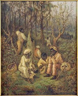
The Great Dismal Swamp maroons were people who inhabited the swamplands of the Great Dismal Swamp in Virginia and North Carolina after escaping enslavement. Although conditions were harsh, research suggests that thousands lived there between about 1700 and the 1860s. Harriet Beecher Stowe told the maroon people's story in her 1856 novel Dred: A Tale of the Great Dismal Swamp. The most significant research on the settlements began in 2002 with a project by Dan Sayers of American University.
Paleontology in West Virginia refers to paleontological research occurring within or conducted by people from the U.S. state of West Virginia. West Virginia's fossil record begins in the Cambrian. From that time through the rest of the early Paleozoic, the state was at least partially submerged under a shallow sea. The Paleozoic seas of West Virginia were home to creatures like corals, eurypterids, graptolites, nautiloids, and trilobites at varying times. During the Carboniferous period, the sea was replaced by lushly vegetated coastal swamps. West Virginia is an excellent source of fossil plants due to these deposits. These swamps were home to amphibians. A gap in the local rock record spans from the Permian to the end of the Cenozoic. West Virginia was never the site of glacial activity during the Ice Age, but the state was home to creatures like mammoths, mastodons, and giant ground sloths. One local ground sloth, Megalonyx jeffersonii, was subject to the scholarly investigations of Thomas Jefferson, who misinterpreted the large-clawed remains as belonging to a lion-like predator. In 2008, this species was designated the West Virginia state fossil.


