Geneva, Washington

Last updated

Geneva, Washington
CDP
Whatcom County Washington Incorporated and Unincorporated areas Geneva Highlighted.svg
Location of Geneva, Washington
Coordinates: 48°44′48″N122°24′21″W / 48.74667°N 122.40583°W / 48.74667; -122.40583
CountryUnited States
State Washington
County Whatcom
Area
  Total1.3 sq mi (3.3 km2)
  Land1.0 sq mi (2.7 km2)
  Water0.2 sq mi (0.6 km2)
Elevation
446 ft (136 m)
Population
 (2020)
  Total2,652
  Density2,000/sq mi (800/km2)
Time zone UTC-8 (Pacific (PST))
  Summer (DST) UTC-7 (PDT)
FIPS code 53-26420 [1]
GNIS feature ID1512236 [2]

Geneva is an unincorporated area and census-designated place (CDP) in Whatcom County, Washington, United States. The population was 2,652 at the 2020 census. [3]

Contents

Based on per capita income, Geneva ranks 85th of 522 areas in the state of Washington to be ranked. It is also the highest rank achieved in Whatcom County.[ citation needed ]

Geography

Geneva is located at 48°44′48″N122°24′21″W / 48.746730°N 122.405775°W / 48.746730; -122.405775 (48.746730, -122.405775). [4]

According to the United States Census Bureau, the CDP has a total area of 1.3 square miles (3.3 km2), of which, 1.0 square miles (2.7 km2) of it is land and 0.2 square miles (0.6 km2) of it (18.75%) is water.

Demographics

Historical population
CensusPop.Note
2000 2,257
2010 2,3212.8%
2020 2,65214.3%

As of the census [1] of 2000, there were 2,257 people, 778 households, and 655 families residing in the CDP. The population density was 2,166.6 people per square mile (837.9/km2). There were 809 housing units at an average density of 776.6/sq mi (300.3/km2). The racial makeup of the CDP was 95.92% White, 0.22% African American, 0.84% Native American, 0.75% Asian, 0.04% Pacific Islander, 0.97% from other races, and 1.24% from two or more races. Hispanic or Latino of any race were 2.53% of the population.

There were 778 households, out of which 43.6% had children under the age of 18 living with them, 73.9% were married couples living together, 6.7% had a female householder with no husband present, and 15.8% were non-families. 11.7% of all households were made up of individuals, and 3.2% had someone living alone who was 65 years of age or older. The average household size was 2.90 and the average family size was 3.11.

In the CDP, the age distribution of the population shows 29.5% under the age of 18, 6.6% from 18 to 24, 27.5% from 25 to 44, 27.9% from 45 to 64, and 8.6% who were 65 years of age or older. The median age was 38 years. For every 100 females, there were 100.4 males. For every 100 females age 18 and over, there were 96.3 males.

The median income for a household in the CDP was $65,324, and the median income for a family was $71,389. Males had a median income of $48,103 versus $40,089 for females. The per capita income for the CDP was $25,374. None of the families and 2.0% of the population were living below the poverty line, including no under eighteens and none of those over 64.

Related Research Articles

<span class="mw-page-title-main">Geneva, Pennsylvania</span> Census-designated place in Pennsylvania, United States

Geneva is a census-designated place in Crawford County, Pennsylvania, United States. The population was 109 at the 2010 census.

<span class="mw-page-title-main">Lakeland South, Washington</span> Census-designated place in Washington, United States

Lakeland South is a census-designated place (CDP) in King County, Washington, United States. The population was 13,169 at the 2020 census.

<span class="mw-page-title-main">Maple Heights-Lake Desire, Washington</span> Census-designated place in Washington, United States

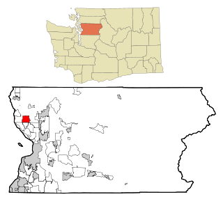
Maple Heights-Lake Desire is a census-designated place (CDP) in King County, Washington, United States. At the 2020 census, the population was 3,873.

<span class="mw-page-title-main">Bay View, Washington</span> CDP in Washington, United States

Bay View is a census-designated place (CDP) in Skagit County, Washington, United States. The population was 812 at the 2020 census. It is included in the Mount Vernon–Anacortes, Washington Metropolitan Statistical Area.

<span class="mw-page-title-main">Lake Cavanaugh, Washington</span> CDP in Washington, United States

Lake Cavanaugh is a census-designated place (CDP) in Skagit County, Washington, United States. The population was 200 at the 2020 census. It is included in the Mount Vernon–Anacortes, Washington Metropolitan Statistical Area.

<span class="mw-page-title-main">Arlington Heights, Washington</span> CDP in Washington, United States

Arlington Heights is a census-designated place (CDP) in Snohomish County, Washington, United States. As of the 2020 census, the population was 2,477, up from 2,284 at the 2010 census.

<span class="mw-page-title-main">Cathan, Washington</span> Former CDP in Washington, United States

Cathan is a former census-designated place (CDP) in Snohomish County, Washington, United States. The population was 526 at the 2000 census. The CDP was discontinued at the 2010 census.

<span class="mw-page-title-main">Lake Goodwin, Washington</span> Former CDP in Washington, United States

Lake Goodwin is a former census-designated place (CDP) in Snohomish County, Washington, United States. The population was 3,354 at the 2000 census. The CDP was discontinued at the 2010 census.

<span class="mw-page-title-main">Lake Ketchum, Washington</span> CDP in Washington, United States

Lake Ketchum is a census-designated place (CDP) in Snohomish County, Washington, United States. The population was 1,268 at the 2020 census, up from 930 at the 2010 census.

<span class="mw-page-title-main">Lochsloy, Washington</span> CDP in Washington, United States

Lochsloy is a census-designated place (CDP) in Snohomish County, Washington, United States. The population was 2,806 at the 2020 census, up from 2,533 at the 2010 census.

<span class="mw-page-title-main">North Marysville, Washington</span> CDP in Washington, United States

North Marysville is a census-designated place (CDP) in Snohomish County, Washington, United States. The majority of the community and its 20,000 residents were annexed into the city of Marysville in 2009. The population was 108 at the 2010 census.

<span class="mw-page-title-main">Northwest Stanwood, Washington</span> CDP in Washington, United States

Northwest Stanwood is a census-designated place (CDP) in Snohomish County, Washington, United States. The population was 137 at the 2020 census. The CDP was known as North Stanwood prior to the 2010 census, and it included area that is now part of the city of Stanwood.

<span class="mw-page-title-main">Tulalip Bay, Washington</span> Former CDP in Washington, United States

Tulalip Bay is a former census-designated place (CDP) in western Snohomish County, Washington, United States. The population was 1,561 at the 2000 census. The CDP was discontinued at the 2010 census. It is the largest community within the reservation of the federally recognized Tulalip Tribes of Washington.

<span class="mw-page-title-main">Acme, Washington</span> Census-designated place in Washington, United States

Acme is a rural unincorporated community, and census-designated place in Whatcom County, Washington, United States. There is a general store, post office, gas station, diner, elementary school and two churches located there. Acme is also included in, and the source-name for, a larger census-designated place (CDP). The Census Bureau no longer tracks the population for the village itself, but for the entire CDP the population was 229 at the 2020 census, down from 246 at the 2010 census.

<span class="mw-page-title-main">Deming, Washington</span> CDP in Washington, United States

Deming is a census-designated place (CDP) in Whatcom County, Washington, United States, along the Nooksack River. It is named for its first postmaster, George Deming. The community population was 339 at the 2020 census.

<span class="mw-page-title-main">Glacier, Washington</span> CDP in Washington, United States

Glacier is a census-designated place in the North Fork Nooksack River Valley, at an elevation of 906 ft., just 10 miles northwest of the Mount Baker Summit towering nearly 10,000 ft above it, in Whatcom County, Washington, United States. The population was 300 at the 2020 census.

<span class="mw-page-title-main">Kendall, Washington</span> CDP in Washington, United States

Kendall is a census-designated place (CDP) in Whatcom County, Washington, United States. The population was 191 at the 2010 census.

<span class="mw-page-title-main">Maple Falls, Washington</span> CDP in Washington, United States

Maple Falls is a census-designated place (CDP) in Whatcom County, Washington, United States. The population was 291 at the 2020 census.

<span class="mw-page-title-main">Marietta-Alderwood, Washington</span> Place in Washington, United States

Marietta-Alderwood is a census-designated place (CDP) in Whatcom County, Washington, United States. The population was 3,906 at the 2010 census. Parts of Marietta-Alderwood were annexed into Bellingham in 2019, while the rest remains an unincorporated area.

<span class="mw-page-title-main">Peaceful Valley, Washington</span> CDP in Washington, United States

Peaceful Valley is a census-designated place (CDP) in Whatcom County, Washington, United States, near Kendall. The population was 3,015 at the 2020 census.

References

  1. 1 2 "U.S. Census website". United States Census Bureau . Retrieved January 31, 2008.
  2. "US Board on Geographic Names". United States Geological Survey. October 25, 2007. Retrieved January 31, 2008.
  3. "Census Bureau profile: Geneva, Washington". United States Census Bureau. May 2023. Retrieved May 9, 2024.
  4. "US Gazetteer files: 2010, 2000, and 1990". United States Census Bureau. February 12, 2011. Retrieved April 23, 2011.