Peaceful Valley, Washington

Last updated

Peaceful Valley
CDP
Whatcom County Washington Incorporated and Unincorporated areas Peaceful Valley Highlighted.svg
Location of Peaceful Valley, Washington
Coordinates: 48°56′34″N122°8′51″W / 48.94278°N 122.14750°W / 48.94278; -122.14750
CountryUnited States
State Washington
County Whatcom
Area
  Total17.0 sq mi (44.0 km2)
  Land16.9 sq mi (43.9 km2)
  Water0.0 sq mi (0.1 km2)
Population
 (2020)
  Total3,015
  Density180/sq mi (69/km2)
Time zone UTC-8 (Pacific (PST))
  Summer (DST) UTC-7 (PDT)
ZIP code
98266 [1]
Area code 360
FIPS code 53-53800 [2]

Peaceful Valley is a census-designated place (CDP) in Whatcom County, Washington, United States, near Kendall. The population was 3,015 at the 2020 census. [3]

Contents

Geography

Peaceful Valley is located at 48°56′34″N122°8′51″W / 48.94278°N 122.14750°W / 48.94278; -122.14750 (48.942689, -122.147401). [4]

According to the United States Census Bureau, the CDP has a total area of 17.0 square miles (44.0 km2), of which, 16.9 square miles (43.9 km2) of it is land and 0.1 square miles (0.1 km2) of it (0.29%) is water.

Demographics

As of the census [2] of 2000, there were 2,448 people, 787 households, and 571 families residing in the CDP. The population density was 144.5 people per square mile (55.8/km2). There were 1,156 housing units at an average density of 68.3/sq mi (26.3/km2). The racial makeup of the CDP was 92.24% White, 0.29% African American, 2.21% Native American, 0.45% Asian, 0.20% Pacific Islander, 1.18% from other races, and 3.43% from two or more races. Hispanic or Latino of any race were 4.25% of the population.

There were 787 households, out of which 45.0% had children under the age of 18 living with them, 53.9% were married couples living together, 11.4% had a female householder with no husband present, and 27.4% were non-families. 18.6% of all households were made up of individuals, and 3.2% had someone living alone who was 65 years of age or older. The average household size was 3.11 and the average family size was 3.61.

In the CDP, the age distribution of the population shows 38.1% under the age of 18, 8.8% from 18 to 24, 30.9% from 25 to 44, 16.8% from 45 to 64, and 5.4% who were 65 years of age or older. The median age was 28 years. For every 100 females, there were 105.0 males. For every 100 females age 18 and over, there were 103.6 males.

The median income for a household in the CDP was $32,357, and the median income for a family was $34,141. Males had a median income of $31,853 versus $19,833 for females. The per capita income for the CDP was $12,733. About 27.7% of families and 36.4% of the population were below the poverty line, including 52.8% of those under age 18 and none of those age 65 or over.

Since the 1990s the community has experienced a considerable influx of Russians and Russian Americans, many of whom are evangelical Christians who were granted asylum in the United States. [5] 34.7% of the children and 24% of the general population speak Russian as a first language and 12.2% of the population were born in Russia. [6]

Related Research Articles

<span class="mw-page-title-main">Strawberry, Marin County, California</span> Census-designated place in California, United States

Strawberry is a census-designated place (CDP) and an unincorporated district of Marin County, California, United States. It shares a ZIP code (94941) with Mill Valley and falls within its school districts; however, it is considered within the sphere of influence of the town of Tiburon. It is largely separated from Mill Valley by U.S. Route 101. Its population was 5,447 at the 2020 census.

<span class="mw-page-title-main">Tamalpais-Homestead Valley, California</span> Census-designated place in California, United States

Tamalpais-Homestead Valley is a census-designated place (CDP) in Marin County, California, United States. The population was 11,492 at the 2020 census.

<span class="mw-page-title-main">Green Valley, Solano County, California</span> Census-designated place in California, United States

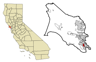
Green Valley is a census-designated place (CDP) located in Solano County, California, United States. It sits in the northeast corner of the San Francisco Bay Area and is located approximately 45 miles (72 km) from Sacramento, approximately 38 miles (61 km) from San Francisco, approximately 32 miles (51 km) from Oakland, less than 15 miles (24 km) from Napa Valley, and less than 15 miles (24 km) from both the Carquinez Bridge and the Benicia Bridge.

<span class="mw-page-title-main">Regina, New Mexico</span> CDP in New Mexico, United States

Regina is a census-designated place (CDP)) in Sandoval County, New Mexico, United States. The population was 99 at the 2000 census. It is part of the Albuquerque Metropolitan Statistical Area. It was named for Regina, Saskatchewan.

<span class="mw-page-title-main">Liberty City, Texas</span> Census-designated place in Texas, United States

Liberty City is a census-designated place (CDP) in Gregg County, Texas, United States. The population was 2,721 at the 2020 census, an increase over the figure of 2,351 tabulated in 2010.

<span class="mw-page-title-main">Cienegas Terrace, Texas</span> CDP in Texas, United States

Cienegas Terrace is a census-designated place (CDP) in Val Verde County, Texas, United States. The population was 3,424 at the 2010 census.

<span class="mw-page-title-main">Hobart, Washington</span> Census-designated place in Washington, United States

Hobart is an unincorporated community and census-designated place (CDP) in King County, Washington, United States. The population was 6,767 at the 2020 census.

<span class="mw-page-title-main">Maple Heights-Lake Desire, Washington</span> Census-designated place in Washington, United States

Maple Heights-Lake Desire is a census-designated place (CDP) in King County, Washington, United States. At the 2020 census, the population was 3,873.

<span class="mw-page-title-main">Union Hill-Novelty Hill, Washington</span> Census-designated place in Washington, United States

Union Hill-Novelty Hill is a census-designated place (CDP) in King County, Washington, United States. The area was first recognized by the Census Bureau in the 2000 census. The population was 22,683 at the 2020 census.

<span class="mw-page-title-main">Lake Cavanaugh, Washington</span> CDP in Washington, United States

Lake Cavanaugh is a census-designated place (CDP) in Skagit County, Washington, United States. The population was 200 at the 2020 census. It is included in the Mount Vernon–Anacortes, Washington Metropolitan Statistical Area.

<span class="mw-page-title-main">Arlington Heights, Washington</span> CDP in Washington, United States

Arlington Heights is a census-designated place (CDP) in Snohomish County, Washington, United States. As of the 2020 census, the population was 2,477, up from 2,284 at the 2010 census.

<span class="mw-page-title-main">Lake Goodwin, Washington</span> Former CDP in Washington, United States

Lake Goodwin is a former census-designated place (CDP) in Snohomish County, Washington, United States. The population was 3,354 at the 2000 census. The CDP was discontinued at the 2010 census.

<span class="mw-page-title-main">Lake Ketchum, Washington</span> CDP in Washington, United States

Lake Ketchum is a census-designated place (CDP) in Snohomish County, Washington, United States. The population was 1,268 at the 2020 census, up from 930 at the 2010 census.

<span class="mw-page-title-main">Lochsloy, Washington</span> CDP in Washington, United States

Lochsloy is a census-designated place (CDP) in Snohomish County, Washington, United States. The population was 2,806 at the 2020 census, up from 2,533 at the 2010 census.

<span class="mw-page-title-main">Northwest Stanwood, Washington</span> CDP in Washington, United States

Northwest Stanwood is a census-designated place (CDP) in Snohomish County, Washington, United States. The population was 137 at the 2020 census. The CDP was known as North Stanwood prior to the 2010 census, and it included area that is now part of the city of Stanwood.

<span class="mw-page-title-main">Shaker Church, Washington</span> Former CDP in Washington, United States

Shaker Church is a former census-designated place (CDP) in Snohomish County, Washington, United States. The population was 787 at the 2000 census. The CDP was discontinued at the 2010 census.

<span class="mw-page-title-main">Acme, Washington</span> Census-designated place in Washington, United States

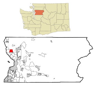
Acme is a rural unincorporated community, and census-designated place in Whatcom County, Washington, United States. There is a general store, post office, gas station, diner, elementary school and two churches located there. Acme is also included in, and the source-name for, a larger census-designated place (CDP). The Census Bureau no longer tracks the population for the village itself, but for the entire CDP the population was 229 at the 2020 census, down from 246 at the 2010 census.

<span class="mw-page-title-main">Deming, Washington</span> CDP in Washington, United States

Deming is a census-designated place (CDP) in Whatcom County, Washington, United States, along the Nooksack River. It is named for its first postmaster, George Deming. The community population was 339 at the 2020 census.

<span class="mw-page-title-main">Geneva, Washington</span> CDP in Washington, United States

Geneva is an unincorporated area and census-designated place (CDP) in Whatcom County, Washington, United States. The population was 2,652 at the 2020 census.

<span class="mw-page-title-main">Kendall, Washington</span> CDP in Washington, United States

Kendall is a census-designated place (CDP) in Whatcom County, Washington, United States. The population was 191 at the 2010 census.

References

  1. "Peaceful Valley WA ZIP Code". zipdatamaps.com. 2023. Retrieved January 26, 2023.
  2. 1 2 "U.S. Census website". United States Census Bureau . Retrieved January 31, 2008.
  3. "Census Bureau profile: Peaceful Valley, Washington". United States Census Bureau. May 2023. Retrieved May 9, 2024.
  4. "US Gazetteer files: 2010, 2000, and 1990". United States Census Bureau. February 12, 2011. Retrieved April 23, 2011.
  5. Cook, Rebecca. "Russians drawn to Peaceful Valley enclave". The Seattle Times. Retrieved January 12, 2016.
  6. "Data Center Results". Archived from the original on June 19, 2006. Retrieved August 10, 2013.