The Ohio River is a 981-mile (1,579 km) long river in the midwestern United States that flows southwesterly from western Pennsylvania south of Lake Erie to its mouth on the Mississippi River at the southern tip of Illinois. It is the second largest river by discharge volume in the United States and the largest tributary by volume of the north-south flowing Mississippi River that divides the eastern from western United States. The river flows through or along the border of six states, and its drainage basin includes parts of 15 states. Through its largest tributary, the Tennessee River, the basin includes several states of the southeastern U.S. It is the source of drinking water for three million people.
Charleston is the most populous city in, and the capital of, the U.S. state of West Virginia. Located at the confluence of the Elk and Kanawha rivers, the population during the 2017 Census Estimate was 47,929. The Charleston metropolitan area as a whole had 214,406 residents. Charleston is the center of government, commerce, and industry for Kanawha County, of which it is the county seat.
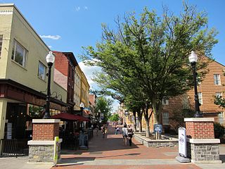
Winchester is an independent city located in the northwestern portion of the Commonwealth of Virginia in the United States. As of the 2010 census, the population was 26,203. As of 2015, its population is an estimated 27,284. It is the county seat of Frederick County, although the two are separate jurisdictions. The Bureau of Economic Analysis combines the city of Winchester with surrounding Frederick County for statistical purposes.

West Virginia University (WVU) is a public, land-grant, space-grant, research-intensive university in Morgantown, West Virginia, United States. Its other campuses include the West Virginia University Institute of Technology in Beckley and Potomac State College of West Virginia University in Keyser; and a second clinical campus for the University's medical and dental schools at Charleston Area Medical Center in Charleston. WVU Extension Service provides outreach with offices in all of West Virginia's 55 counties. Since 2001, WVU has been governed by the West Virginia University Board of Governors.
Gilkerson's Union Giants were an independent Negro semi-pro baseball team headed by Robert Gilkerson in the 1920s and 1930s.

Hezekiah Bradley Smith, was an American inventor and a Democratic Party politician who represented New Jersey's 2nd congressional district in the United States House of Representatives from 1879 to 1881.

This is a list of properties and historic districts in West Virginia that are listed on the National Register of Historic Places. There are listings in every one of West Virginia's 55 counties.

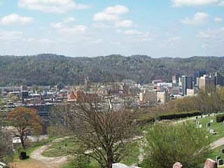
The Huntington–Ashland metropolitan area is the largest metropolitan statistical area in West Virginia and includes seven counties across three states: West Virginia, Kentucky, and Ohio. New definitions from February 28, 2013 placed the population at 361,580. The MSA is nestled along the banks of the Ohio River within the Appalachian Plateau region. The area is referred to locally as the "Tri-State area". In addition, the three largest cities are referred to as the River Cities.

The Nevins Covered Bridge is a single span Burr Arch Truss covered bridge that crosses Little Raccoon Creek on County Road 130 East, just southeast of Catlin, Indiana. It was built in 1920 by Joseph A. Britton and Son. Prior to the reconstruction of the Bridgeton Bridge in 2006, the Nevins Bridge was the newest covered bridge in Parke County.

John Gilkerson is an American soccer player.
Walter C. "Steel Arm" Davis was an American Negro league baseball player from 1920 to 1938. He played for the Dayton Marcos, Detroit Stars, Chicago American Giants, Nashville Elite Giants, Gilkerson's Union Giants and Brooklyn Eagles.

St. Bonaventure Church Complex is a church and associated buildings located off NE 14 in Raeville, Nebraska within the Roman Catholic Archdiocese of Omaha.
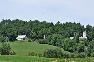
The William and Agnes Gilkerson Farm, also known more recently as the Kitchel Hill Farm, is a historic farmstead on Kitchel Hill Road in Barnet, Vermont. Established in the late 18th century by Scottish immigrants, it includes one of the finest known examples of a rubblestone farmhouse in the region. The property was listed on the National Register of Historic Places in 1992.
Laura Spong was an American painter, who in her later years became one of South Carolina's leading non-objective artists.
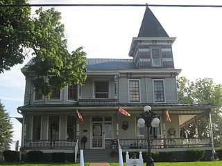
The John Barnd House is a historic house in Kearney, Nebraska. It was built in 1892 for John Barnd, a veteran of the Union Army during the Civil War of 1861-1865 who founded the Mutual Loan and Investment Company of Kearney and was the co-owner of the Commercial and Savings Bank of Kearney. The house was designed in the Queen Anne architectural style. It has been listed on the National Register of Historic Places since March 31, 1983.