Related Research Articles

The Appalachian Mountains, often called the Appalachians, are a system of mountains in eastern to northeastern North America. The Appalachians first formed roughly 480 million years ago during the Ordovician Period. They once reached elevations similar to those of the Alps and the Rocky Mountains before experiencing natural erosion. The Appalachian chain is a barrier to east–west travel, as it forms a series of alternating ridgelines and valleys oriented in opposition to most highways and railroads running east–west.

Scouting in West Virginia has a long history, from the 1910s to the present day, serving thousands of youth in programs that suit the environment in which they live.

The Shenandoah Valley is a geographic valley and cultural region of western Virginia and the Eastern Panhandle of West Virginia in the United States. The valley is bounded to the east by the Blue Ridge Mountains, to the west by the eastern front of the Ridge-and-Valley Appalachians, to the north by the Potomac River and to the south by the James River. The cultural region covers a larger area that includes all of the valley plus the Virginia highlands to the west, and the Roanoke Valley to the south. It is physiographically located within the Ridge and Valley province and is a portion of the Great Appalachian Valley.

The Allegheny Mountain Range, informally the Alleghenies, is part of the vast Appalachian Mountain Range of the Eastern United States and Canada and posed a significant barrier to land travel in less developed eras. The Allegheny Mountains have a northeast–southwest orientation, running for about 400 miles (640 km) from north-central Pennsylvania, southward through western Maryland and eastern West Virginia.

The Ridge-and-Valley Appalachians, also called the Ridge and Valley Province or the Valley and Ridge Appalachians, are a physiographic province of the larger Appalachian division and are also a belt within the Appalachian Mountains extending from southeastern New York in the north through northwestern New Jersey, westward into Pennsylvania through the Lehigh Valley, and southward into Maryland, West Virginia, Virginia, Kentucky, Tennessee, Georgia, and Alabama. They form a broad arc between the Blue Ridge Mountains and the Appalachian Plateau physiographic province. They are characterized by long, even ridges, with long, continuous valleys in between.

The Shenandoah River is the principal tributary of the Potomac River, 55.6 miles (89.5 km) long with two forks approximately 100 miles (160 km) long each, in the U.S. states of Virginia and West Virginia. The river and its tributaries drain the central and lower Shenandoah Valley and the Page Valley in the Appalachians on the west side of the Blue Ridge Mountains, in northwestern Virginia and the Eastern Panhandle of West Virginia. There is a hydroelectric plant along the Shenandoah river constructed in 2014 by Dominion.

Tazewell County is a county located in the southwestern portion of the U.S. state of Virginia. As of the 2020 census, the population was 40,429. Its county seat is Tazewell.
Hidden Valley may refer to:
Warm Springs is a census-designated place (CDP) in and the county seat of Bath County, Virginia, United States. The population as of the 2010 census was 123. It lies along U.S. Route 220 near the center of the county. Warm Springs includes the historical mill town called Germantown. To the west lies West Warm Springs.

Harmony Gold is the largest gold mining company in South Africa. Harmony operates in South Africa and in Papua New Guinea. The company has nine underground mines, one open-pit mine and several surface operations in South Africa. In Papua New Guinea, it has Hidden Valley, an open-pit gold and silver mine and a 50% interest in the Morobe Mining Joint Venture, which includes the Wafi-Golpu project and extensive exploration tenements. Outside the joint venture, Harmony's own exploration portfolio focuses principally on highly prospective areas in Papua New Guinea.
The Roanoke Valley in southwest Virginia is an area adjacent to and including the Roanoke River between the Blue Ridge Mountains to the east and the Appalachian Plateau to the west. The valley includes much of Roanoke County, as well as the two independent cities of Roanoke and Salem.
The AA Blue Ridge District is a district in the Region III of the Virginia High School League. The district is centered around the Roanoke Valley in Southwest Virginia and is named for the Blue Ridge Mountains, which feature prominently in the region's geography.

Hidden Valley High School is a public high school in Roanoke County, Virginia. It is one of the five high schools in the Roanoke County Public Schools system. The other four high schools which serve Roanoke County are Cave Spring High School, Glenvar High School, Northside High School and William Byrd High School.
Robert Nutting is an American businessman and sports team owner. Since 2007, He has been the principal owner and chairman of the board of the Pittsburgh Pirates of Major League Baseball. His other business activities include serving as president & CEO of Ogden Newspapers Inc. He is also the former Chairman of Seven Springs Mountain Resort, Hidden Valley Resort, and Laurel Mountain Ski Area, which he sold to Vail Resorts in December 2021 in a $118 million deal.

Hidden Valley is the name given to a wide, mostly unforested floodplain of the Jackson River some miles north of Virginia route 39 and west of US Route 220 in the George Washington National Forest. The Forest Service maintains the recreation area, including camping, 180 acres of hayfields, and 20 miles of trails.
Rachel Ruth Cosgrove Payes, also known as E.L. Arch and Joanne Kaye was an American genre novelist, and author of books on the Land of Oz.

Hidden Valley Wildlife Management Area is a 6,400-acre (26 km2) Wildlife Management Area in Washington County, Virginia, along its border with Russell County. The area is typified by mountainous mature hardwood forests that have regenerated on land logged in the early twentieth century; a number of small openings which are also maintained as habitat for local wildlife. Its elevation ranges from 2,000 to 4,000 feet above sea level. At the head of the valley is the 60-acre (24 ha) Hidden Valley Lake, which serves as the source of Brumley Creek.
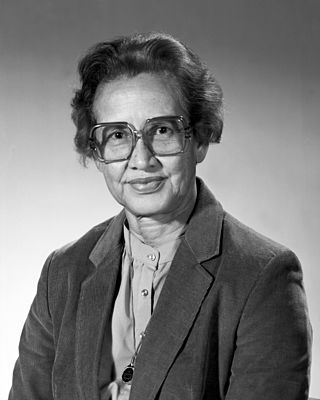
Katherine Johnson was an American mathematician whose calculations of orbital mechanics as a NASA employee were critical to the success of the first and subsequent U.S. crewed spaceflights. During her 33-year career at NASA and its predecessor, she earned a reputation for mastering complex manual calculations and helped pioneer the use of computers to perform the tasks. The space agency noted her "historical role as one of the first African-American women to work as a NASA scientist".

The Hidden Valley Rockshelter (44-BA-31) is a significant archaeological site located near the community of Warm Springs in Bath County, Virginia, United States. A large rockshelter located near the Jackson River, it has been occupied by humans for thousands of years, and it has been named a historic site.
References
Municipalities and communities of Wayne County, West Virginia, United States | ||
|---|---|---|
| Cities |  | |
| Towns | ||
| CDPs | ||
| Unincorporated communities |
| |
| Footnotes | ‡This populated place also has portions in an adjacent county or counties | |
| | This article about a location in Wayne County, West Virginia is a stub. You can help Wikipedia by expanding it. |