
Wayne County is a county in the U.S. state of Utah. As of the 2020 census, the population was 2,486, making it the fourth-least populous county in Utah. Its county seat is Loa.
Wayne County is the westernmost county in the U.S. state of West Virginia. As of the 2020 census, the population was 38,982. Its county seat is Wayne. The county was founded in 1842 and named for General "Mad" Anthony Wayne.
Cabell County is located in the U.S. state of West Virginia. As of the 2020 census, the population was 94,350, making it West Virginia's fourth most-populous county. Its county seat is Huntington. The county was organized in 1809 and named for William H. Cabell, the Governor of Virginia from 1805 to 1808. Cabell County is part of the Huntington-Ashland, WV-KY-OH Metropolitan Statistical Area.

Rockingham County is a county located in the U.S. state of Virginia. As of the 2020 census, the population was 83,757. Its county seat is the independent city of Harrisonburg.

Halifax County is a county located in the Commonwealth of Virginia. As of the 2020 census, the population was 34,022. Its county seat is Halifax.
Augusta County is a county in the Shenandoah Valley on the western edge of the Commonwealth of Virginia in the United States. The second-largest county of Virginia by total area, it completely surrounds the independent cities of Staunton and Waynesboro. Its county seat is Staunton, but most of the administrative services have offices in neighboring Verona.

Wayne County is a county located in south central Tennessee, along the Alabama border. As of the 2020 census, the population was 16,232. Its county seat is Waynesboro. The county is named after General "Mad Anthony" Wayne, a prominent military leader in the American Revolutionary War.
Wayne is a county in the Commonwealth of Pennsylvania. It is part of Northeastern Pennsylvania. The county's population was 51,155 at the 2020 census. The county seat is the Borough of Honesdale. The county was formed from part of Northampton County on March 21, 1798, and was named for the Revolutionary War General Anthony Wayne.

Monroe County is a county located on the eastern border of the U.S. state of Ohio, across the Ohio River from West Virginia. As of the 2020 census, the population was 13,385, making it the second-least populous county in Ohio. Its county seat is Woodsfield. The county was created in 1813 and later organized in 1815.

Columbiana County is a county located in the U.S. state of Ohio. As of the 2020 census, the population was 101,877. The county seat is Lisbon and its largest city is Salem. The county name is derived from the explorer of the Americas, Christopher Columbus.

Belmont County is a county in the U.S. state of Ohio. As of the 2020 United States Census, the population was 66,497. Its county seat is St. Clairsville, while its largest city is Martins Ferry. The county was created on September 7, 1801, and organized on November 7, 1801. It takes its name from the French for "beautiful mountain".

Wayne County is a county in the U.S. state of Nebraska. As of the 2020 census, the population was 9,697. Its county seat is Wayne.

Wayne County is the most populous county in the U.S. state of Michigan. As of 2020, the United States Census placed its population at 1,793,561, making it the 19th-most populous county in the United States. The county seat is Detroit. The county was founded in 1796 and organized in 1815. Wayne County is included in the Detroit-Warren-Dearborn, MI Metropolitan Statistical Area. It is one of several U.S. counties named after Revolutionary War-era general Anthony Wayne.

Wayne County is a county located in the U.S. state of Iowa. As of the 2020 census, the population was 6,497, making it the sixth-least populous county in Iowa. The county seat is Corydon.

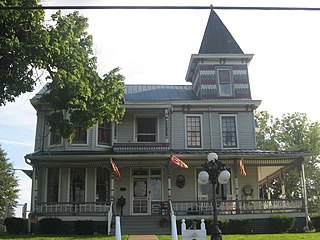
Wayne is a town in and the county seat of Wayne County, West Virginia, United States. The population was 1,441 at the 2020 census. It is part of the Huntington–Ashland metropolitan area.
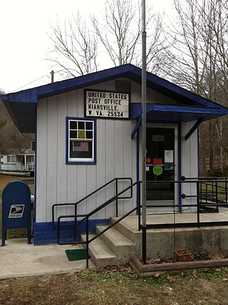
Kiahsville is an unincorporated community in southern Wayne County, West Virginia, United States. It is a part of the Huntington-Ashland, WV-KY-OH, Metropolitan Statistical Area (MSA). As of the 2000 census, the MSA had a population of 288,649. Its sister town is nearby Cove Gap.
West Virginia's 6th Senate district is one of 17 districts in the West Virginia Senate. It is currently represented by Republicans Mark Maynard and Chandler Swope. All districts in the West Virginia Senate elect two members to staggered four-year terms. District 6 is currently the most Republican-leaning district in the Senate.

West Virginia's 7th Senate district is one of 17 districts in the West Virginia Senate. It is currently represented by Republican Mike Stuart and Republican Rupie Phillips. All districts in the West Virginia Senate elect two members to staggered four-year terms.


