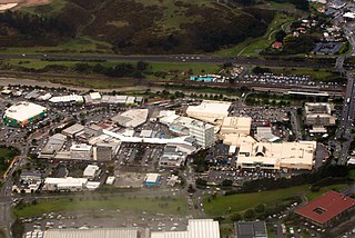
Porirua, a city in the Wellington Region of the North Island of New Zealand, is one of the four cities that constitute the Wellington metropolitan area. The name 'Porirua' is a corruption of 'Pari-rua', meaning "the tide sweeping up both reaches". It almost completely surrounds Porirua Harbour at the southern end of the Kāpiti Coast. As of June 2023, Porirua has a population of 60,900.

The suburb of Plimmerton lies in the northwest part of the city of Porirua in New Zealand, adjacent to some of the city's more congenial beaches. State Highway 59 and the North Island Main Trunk railway line pass just east of the main shopping and residential area.

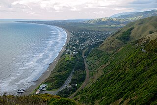
Pukerua Bay is a small seaside suburb at the southern end of the Kāpiti Coast, New Zealand. In local government terms it is the northernmost suburb of Porirua City, in the Wellington Region. It is 12 km north of the Porirua City Centre on State Highway 59, and 30 km north of central Wellington. In Māori, the words puke rua literally mean two hills but it is not clear to which hills the name refers.
Ngāti Toa, Ngāti Toarangatira or Ngāti Toa Rangatira, is a Māori iwi (tribe) based in the southern North Island and in the northern South Island of New Zealand. Its rohe extends from Whanganui in the north, Palmerston North in the east, and Kaikōura and Hokitika in the south. Ngāti Toa remains a small iwi with a population of only about 9000. The iwi is centred around Porirua, Plimmerton, Kāpiti, Blenheim and Arapaoa Island. It has four marae: Takapūwāhia and Hongoeka in Porirua City, and Whakatū and Wairau in the north of the South Island. Ngāti Toa's governing body has the name Te Rūnanga o Toa Rangatira.

Tawa is the northernmost suburb within the Wellington city boundary, located roughly 15 km north of Wellington's CBD between Churton Park and Porirua in the North Island of New Zealand. It takes its name from the broadleaf tree, which was once prolific throughout the area, although its most famous tree is the Bucket Tree, a large macrocarpa with the topiary of an upside-down bucket. Tawa is also known for its large number of churches, representing a wide range of Christian denominations.
Paekākāriki is a town in the Kāpiti Coast District in the south-western North Island, New Zealand, and one of the northernmost towns of the wider Wellington region. It lies 22 km (14 mi) north of Porirua and 45 km (28 mi) northeast of the Wellington CBD. The town's name comes from the Māori language and can mean "parakeet perch". Paekākāriki had a population of 1,665 at the time of the 2013 census, up 66 from the 2006 census.

The 8.38 miles (13.49 km) Tawa Flat deviation is a double-track section of the Kapiti Line just north of Wellington, New Zealand with two tunnels; the southernmost section of the North Island Main Trunk railway (NIMT) between Wellington and Auckland. It was built to bypass a limited capacity single track section of the original Wellington and Manawatu Railway (WMR) line which ascended from Wellington to Johnsonville and then descended to Tawa Flat. The original name of Tawa Flat was changed to Tawa in 1959.

Churton Park is a suburb 1.5 km north of Johnsonville in Wellington, the capital city of New Zealand. It was established in the 1970s.
The Ngauranga Gorge is in the Wellington Region of New Zealand. State Highway 1 runs through the gorge, a vital link between central Wellington City and its northern suburbs and Porirua City and the Kāpiti Coast; it is the main route north out of Wellington. It is 2 kilometres (1.2 mi) long and has a grade of approximately 8 percent. Sixty-five thousand vehicles a day travel through it, and it connects the Wellington Urban Motorway with the Johnsonville–Porirua Motorway.

Metlink's Kapiti Line is the electrified southern portion of the North Island Main Trunk railway between New Zealand's capital city, Wellington, and Waikanae on the Kāpiti Coast, operated by Transdev Wellington on behalf of Greater Wellington Regional Council. Trains run frequently every day, with stops at 16 stations. Until 20 February 2011 it was known as the Paraparaumu Line.

The Johnsonville–Porirua Motorway is a motorway in Wellington, New Zealand. The majority of the motorway forms part of State Highway 1, the main route of traffic in and out of the city, with the northernmost 2.1 km (1.3 mi), formerly part of SH 1 until 7 December 2021, designated as State Highway 59. Completed in the 1950s, it was New Zealand's first motorway.

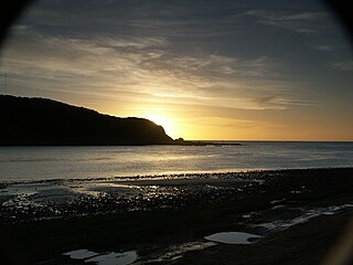
Karehana Bay is a bay and nearby residential area at the western end of Plimmerton, a northern coastal locality of Porirua. It is located near the entrance to the Porirua Harbour, to the south-east of Hongoeka. It is about 5 minutes drive to Karehana Bay from the State Highway 59 turnoff to Plimmerton. The area looks out towards Mana Island and across Cook Strait to the South Island.
Takapu Road railway station is on the suburban rail network of Wellington, New Zealand, on the Kapiti section of the North Island Main Trunk Railway (NIMT). It is double tracked with side platforms. It serves the suburbs of Redwood and Grenada North, and the rural Takapu Valley.

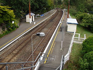
Redwood railway station on the suburban rail network of Wellington, New Zealand, is on the North Island Main Trunk Railway (NIMT). Opening in late 1963, it is double tracked with staggered side platforms; the up platform is on the north side of the Tawa Street level crossing, the down platform on the south. The station serves the suburb of Redwood.

Tawa railway station, originally called Tawa Flat, is on the North Island Main Trunk Railway (NIMT) and is part of the suburban rail network of Wellington, New Zealand. It is double tracked with an island platform, and is 13.75 kilometres (8.54 mi) from Wellington railway station, the southern terminus of the NIMT. The station serves the suburb of Tawa.

Kenepuru railway station is on the North Island Main Trunk Railway (NIMT) in New Zealand, on Wellington's suburban rail network. It is double tracked with side platforms on a curved section of the line, 16.16 km from Wellington railway station, the southern terminus of the NIMT. The station serves the industrial suburb of Kenepuru and is within walking distance of Kenepuru Hospital.

Johnsonville railway station is the terminus of the Johnsonville Line, one of eight stations on the commuter branch railway north of Wellington in New Zealand’s North Island. It serves the suburb of Johnsonville, and as a bus interchange attracts traffic from other suburbs to the north and east.

Battle Hill Farm Forest Park is a regional park near Paekākāriki, in the Kāpiti Coast District and Wellington Region of New Zealand's lower North Island.
Porirua railway station is an important intermediate station in New Zealand on the Kapiti Line from Wellington and is part of Wellington's Metlink suburban rail network operated by Transdev Wellington.
The Old Porirua Road in the 19th century was the main road north up the west coast from Wellington to Porirua in New Zealand. It ran from Kaiwarra up the Ngaio Gorge to Ngaio, Khandallah, Johnsonville and Tawa to the Porirua Harbour. Most of the road still exists, although many sections are now local roads only, having been superseded as through roads.

