Newtown | |
---|---|
Newtown Community Centre | |
![]() | |
Country | New Zealand |
City | Wellington City |
Electoral ward | Paekawakawa/Southern Ward |
Area | |
• Land | 255 ha (630 acres) |
Population (June 2022) [2] | |
• Total | 9,780 |
Hospital(s) | Wellington Hospital |
Mount Cook | Mount Cook [3] | Hataitai |
Vogeltown | ![]() ![]() ![]() ![]() | Evans Bay |
Berhampore | Berhampore | Kilbirnie, Melrose |
The suburb of Newtown lies in the southern part of Wellington in New Zealand. It lies east of Vogeltown, between Mount Cook and Berhampore. The main thoroughfares of Newtown are Riddiford St, leading from Mount Cook to Berhampore and Melrose, and Constable St, leading from Newtown to Kilbirnie.
Originally a working-class suburb, Newtown has followed gentrification trends in recent years, attracting large numbers of immigrants, students and young professionals and resulting in an ethnically diverse population. The Wellington City Council District Plan identifies Newtown as a suburb with an "identifiable or distinct character". [4]
On 16 May 2023, a fire broke out at the 92-bed Loafers Lodge in Newtown. At least six people died, 20 others were injured, and 11 are missing. [5]
Newtown, comprising the statistical areas of Newtown North, Newtown West and Newtown South, covers 2.55 km2 (0.98 sq mi). [1] It had an estimated population of 9,780 as of June 2022, with a population density of 3,835 people per km2.
Year | Pop. | ±% p.a. |
---|---|---|
2006 | 7,881 | — |
2013 | 8,400 | +0.92% |
2018 | 9,180 | +1.79% |
Source: [6] |
Newtown had a population of 9,180 at the 2018 New Zealand census, an increase of 780 people (9.3%) since the 2013 census, and an increase of 1,299 people (16.5%) since the 2006 census. There were 3,351 households. There were 4,314 males and 4,866 females, giving a sex ratio of 0.89 males per female, with 1,056 people (11.5%) aged under 15 years, 3,420 (37.3%) aged 15 to 29, 3,825 (41.7%) aged 30 to 64, and 882 (9.6%) aged 65 or older.
Ethnicities were 65.5% European/Pākehā, 10.1% Māori, 8.2% Pacific peoples, 18.8% Asian, and 8.7% other ethnicities (totals add to more than 100% since people could identify with multiple ethnicities).
The proportion of people born overseas was 35.4%, compared with 27.1% nationally.
Although some people objected to giving their religion, 52.2% had no religion, 29.1% were Christian, 3.7% were Hindu, 4.7% were Muslim, 1.4% were Buddhist and 4.6% had other religions.
Of those at least 15 years old, 3,504 (43.1%) people had a bachelor or higher degree, and 780 (9.6%) people had no formal qualifications. The employment status of those at least 15 was that 4,530 (55.8%) people were employed full-time, 1,194 (14.7%) were part-time, and 477 (5.9%) were unemployed. [6]
Name | Population | Households | Median age | Median income |
---|---|---|---|---|
Newtown North | 2,124 | 678 | 30.6 years | $33,000 [7] |
Newtown West | 3,414 | 1,269 | 29.0 years | $34,300 [8] |
Newtown South | 3,642 | 1,404 | 32.2 years | $30,500 [9] |
New Zealand | 37.4 years | $31,800 |
This section needs additional citations for verification .(June 2021) |
Government House on Rugby Street, Wellington Hospital located on Riddiford Street and Wellington Zoo all lie within the boundaries of Newtown. Newtown Park is located next to the Zoo, off Roy Street and provides a venue for athletics and football. The Park consists of a 400m all-weather running track, grandstand, changing rooms, community rooms and play area. Wellington City Council has spent $3.6 million on modernising facilities at Newtown Park to meet current and future needs for the athletics and soccer sports codes, and the wider community.
The annual Newtown Festival takes place over one day, culminating in the Newtown Festival Street Fair which is usually held on International Children's Day (usually the first Sunday in March). Organised by The Newtown Residents' Association for the past 18 years, the festival has continued to grow. The 2014 Newtown Festival was attended by an estimated 80,000 people. [10] In 2014 the Wellington Gold Awards nominated the organisers of the Newtown Festival for one of their annual awards, citing that the festival is "New Zealand’s largest free annual outdoor street festival." [11]
Newtown School is a co-educational contributing state primary school for Year 1 to 6 students, [12] with a roll of 320 as of April 2023. [13]
The school has a Māori language immersion class, Ngāti Kotahitanga, providing an 80 per cent immersion environment. It also has an indoor heated swimming pool, computer suite, and separate junior and senior playgrounds. [14]
South Wellington Intermediate is a co-educational state intermediate school for Year 7 to 8 students, [15] [16] with a roll of 402. [17]
St Anne's School is a co-educational state-integrated Catholic primary school for Year 1 to 8 students, [18] with a roll of 141 as of April 2023. [19]
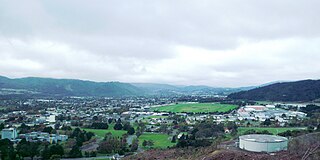
Trentham is the most populous suburb of Upper Hutt, a city in the Wellington region of New Zealand. The suburb is located in a widening of the Hutt Valley, five kilometres to the southwest of the Upper Hutt city centre.
Mount Victoria is a suburb of central Wellington, New Zealand, named after the 196 metres (643 ft) hill Mount Victoria to the east. Mount Victoria's residential area is on its north-western slopes.
Richmond is a town and the seat of the Tasman District Council in New Zealand. It lies 13 kilometres (8 mi) south of Nelson in the South Island, close to the southern extremity of Tasman Bay / Te Tai-o-Aorere. The town, first settled by Europeans in 1842, was named in 1854 after the town of Richmond on Thames near London. The town has an estimated population of 18,450 as of June 2022.
Hataitai is an inner-city suburb of Wellington, the capital of New Zealand, 3.5 kilometres southeast of the city centre. The suburb extends over the southeastern flank of Mount Victoria and down a valley between the Town Belt and a ridge along the shoreline of Evans Bay. Hataitai is bounded by Hepara Street, Grafton Road and the suburb of Roseneath in the north, Wellington Harbour in the east, Cobham Drive, Wellington Road and Crawford Road in the south, and Alexandra Road in the west.
Seatoun, an eastern suburb of Wellington, the capital city of New Zealand, lies on the east coast of the Miramar Peninsula, close to the entrance to Wellington Harbour, some seven kilometres southeast of the CBD. The suburb sits on an exposed promontory close to Barrett Reef, a dangerous area of rocky shallows upon which many ships have foundered, most notably the inter-island ferry TEV Wahine in 1968.
Roslyn is a suburb in the city of Palmerston North, Manawatū-Whanganui, New Zealand.
Takaro is a suburb and constituent ward of Palmerston North, Manawatū-Whanganui, New Zealand.
Palmerston North Central is the central suburb and central business district of Palmerston North, on New Zealand's North Island.
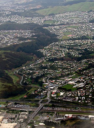
Kilbirnie is a suburb of Wellington in New Zealand, 3 kilometres (1.9 mi) to the south-east of the city centre. Travellers can reach Kilbirnie from the Wellington central business district via the Mount Victoria Tunnel and Hataitai, or over Mount Victoria, or around the coast.
Cannons Creek is a suburb of Porirua City approximately 22km north of Wellington in New Zealand.
Kaiti is a suburb of the New Zealand city of Gisborne. It is located immediately to the east of the city centre, on the opposing bank of the Waimata River.
Hutt Central, a suburb of the city of Lower Hutt in New Zealand, forms part of the urban area of greater Wellington. It includes the Lower Hutt CBD.
Strathmore Park is a suburb of Wellington City, New Zealand. It is located at the southern end of the Miramar Peninsula to the south of the suburb of Miramar, and due east of the airport. A hill suburb, it overlooks Lyall Bay, Evans Bay and several bays along the Seatoun coast close to the mouth of Wellington Harbour, which lies to the east.
Tauranga South is a suburb of Tauranga, on New Zealand's North Island. It is located south-east of Judea, north-east of Gate Pa and south-west of Tauranga Central.
Nayland is a suburb of Stoke, New Zealand. It lies to the north of Stoke, close to Nelson Airport, southwest of Nelson city centre.
Nelson South is an inner suburb of Nelson, New Zealand. It lies to the southwest of Nelson city centre, between it and Bishopdale, close to the foot of The Grampians. The main inland route to Stoke, New Zealand, Waimea Road, is Nelson South's main road.
Ōwhata is a semi-rural suburb of Rotorua in the Bay of Plenty region of New Zealand's North Island.
Tamatea is a suburb in the west of the city of Napier, in the Hawke's Bay Region of New Zealand's eastern North Island.
Western Heights is a suburb of Rotorua in the Bay of Plenty Region of New Zealand's North Island.
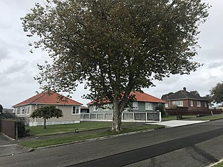
College Estate is a suburb of Whanganui, in the Whanganui District and Manawatū-Whanganui region of New Zealand's North Island.