
Wellington is the capital city of New Zealand. It is located at the south-western tip of the North Island, between Cook Strait and the Remutaka Range. Wellington is the major population centre of the southern North Island, and is the administrative centre of the Wellington Region, which also includes the Kapiti Coast and the Wairarapa. It is the world's southernmost capital of a sovereign state. Wellington features a temperate maritime climate, and is the world's windiest city by average wind speed.

Wellington City Council is a territorial authority in New Zealand, governing the country's capital city, and de facto second-largest city. It consists of the central historic town and certain additional areas within the Wellington metropolitan area, extending as far north as Linden and covering rural areas such as Mākara and Ohariu. The city adjoins Porirua in the north and Hutt City in the north-east. It is one of nine territorial authorities in the Wellington Region.

Karori is a suburb located at the western edge of the urban area of Wellington, New Zealand, 4 km from the city centre and is one of New Zealand's most populous suburbs, with a population of 15,630 in June 2020.

Johnsonville is a large suburb in northern Wellington, New Zealand. It is seven kilometres north of the city centre, at the top of the Ngauranga Gorge, on the main route to Porirua. It is commonly known by locals as "J'ville".

Khandallah is a suburb of Wellington, the capital city of New Zealand. It is located 4 kilometres (2.5 mi) northeast of the city centre, on hills overlooking Wellington Harbour.

Ngaio is an inner suburb of Wellington, the capital city of New Zealand. It is situated on the slopes of Mount Kaukau, 3500 metres north of the city's CBD. It was settled in the 1840s and many of its streets are named after early settler families. Ngaio was originally a logging community known first as Upper Kaiwarra, then as Crofton until 1908. The area was administratively part of a separate local authority called the Onslow Borough Council which amalgamated with Wellington City in 1919.

Stuff Ltd is a privately held news media company operating in New Zealand. It operates Stuff, the country's largest news website, and owns nine daily newspapers, including New Zealand's second and third-highest circulation daily newspapers, The Dominion Post and The Press, and the highest circulation weekly, Sunday Star-Times. Magazines published include TV Guide, New Zealand's top-selling weekly magazine. Stuff also owns social media network Neighbourly.

Avalon is a suburb of Lower Hutt in New Zealand, formed as a private residential development in the 1970s on land formerly occupied by market-gardens on the left (eastern) bank of the Hutt River. It features mostly California-inspired designed houses, often split-level, with 3 or 4 bedrooms.

Mornington is a suburb of Wellington, New Zealand, on the southern hills behind Brooklyn. It is named after the Duke of Wellington's father, the Earl of Mornington. The original Mornington is in County Meath, and was the Irish seat of the Duke's father. It was named in 1878 from the time when J.F.E. Wright (1827-1891) subdivided his land in the south-west of the city in partnership with Jacob Joseph, and created the suburbs of Mornington and Vogeltown.

Belmont, a suburb of Lower Hutt, to the north of Wellington in the North Island of New Zealand, lies on the west bank of the Hutt River, on State Highway 2, the Wellington-Hutt main road, and across the river from the centre of Lower Hutt.

Downstage Theatre was a professional theatre company in Wellington, New Zealand, that ran from 1964 to 2013. For many years it occupied the purpose-built Hannah Playhouse building. Former directors include Mervyn Thompson, and Colin McColl.
Mākara is a locality located at the western edge of Wellington, New Zealand, close to the shore of the Tasman Sea. The suburb is named after the Mākara Stream.

Epuni is a suburb of Lower Hutt, New Zealand situated in the south of the North Island of New Zealand. The suburb lies around one kilometre east of the Lower Hutt CBD.

Crofton Downs is an inner suburb of Wellington, the capital city of New Zealand. It is situated between Ngaio to the northeast Wilton to the south-west and Wadestown to the south. Its border runs on the Korimako Stream that flows south into the Kaiwharawhara Stream and then flows down the Ngaio Gorge into Wellington Harbour.
Paparangi, one of the northern suburbs of Wellington in New Zealand, lies approximately 10 km north of the city centre, north-east of Johnsonville, north-west of Newlands and south of Grenada and Woodridge. The population was 2,841 at the time of the 2013 census, an increase of 96 from the 2006 census population.

The 2016 Kaikoura earthquake was a magnitude 7.8 (Mw) earthquake in the South Island of New Zealand that occurred two minutes after midnight on 14 November 2016 NZDT. Ruptures occurred on multiple faults and the earthquake has been described as the "most complex earthquake ever studied".
Maupuia on the Miramar Peninsula is an eastern suburb of Wellington to the north-west of Miramar. Developed in the 1970s, it is in the Eastern Ward.
Broadmeadows is a minor western suburb of Wellington, New Zealand. It is located to the north of Khandallah and south of Johnsonville. It is located 7 kilometres (4.3 mi) from the Wellington central business district. Despite its name suggesting that the area was once flat open fields, the suburb was created on steeply sloping hills and features the highest streets within Wellington City with a number of houses located more than 300m above sea level. Broadmeadows has a population of 1,635.
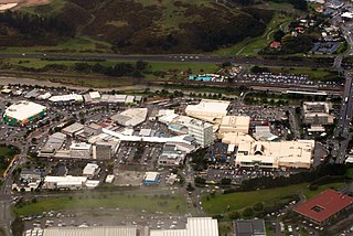
Porirua Central is the central business district and central suburb of Porirua, in the Wellington region of New Zealand's North Island.