
Eastbourne is a suburb of Lower Hutt, a part of Wellington, New Zealand. Lying beside the sea, it is a popular local tourist destination via car from Petone or from ferry crossings from central Wellington. An outer suburb, it lies on the eastern shore of Wellington Harbour, five kilometres south of the main Lower Hutt urban area and directly across the harbour from the Miramar Peninsula in Wellington city. A narrow exposed coastal road connects it with the rest of Lower Hutt via the Eastern Bays and the industrial suburb of Seaview. It is named for Eastbourne in England, another seaside town known as a destination for day-trips.

Miramar is a suburb of Wellington, New Zealand, south-east of the city centre. It is on the Miramar Peninsula, directly east of the isthmus of Rongotai, the site of Wellington International Airport.

Te Motu Kairangi / Miramar Peninsula is a large peninsula on the southeastern side of the city of Wellington, New Zealand. It is located at the entrance to Wellington Harbour, in Wellington's eastern suburbs. According to Māori legend, it was formed when the taniwha Whaitaitai beached as he tried to escape the confines of the harbour. It contains the suburb of Miramar.

Seatoun, an eastern suburb of Wellington, the capital city of New Zealand, lies on the east coast of the Miramar Peninsula, close to the entrance to Wellington Harbour, some seven kilometres southeast of the CBD. The suburb sits on an exposed promontory close to Barrett Reef, a dangerous area of rocky shallows upon which many ships have foundered, most notably the inter-island ferry TEV Wahine in 1968.
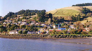
Macandrew Bay is located on the Otago Peninsula in the South Island of New Zealand. It is situated on the edge of Otago Harbour, and is named for pioneer Scottish settler James Macandrew who lived here during his later life. The Te Reo Māori name for the bay, Te Roto Pāteke, refers to the Brown teal formerly prevalent in the area. Early European residents of the area called the bay "The Hundreds", due to the large number of boulders which covered the foreshore.

Okiato or Old Russell is a small town in the Bay of Islands, New Zealand, 7 kilometres (4.3 mi) south of present-day Russell. It was founded in 1840 and served as New Zealand's first national capital until 1841, when the seat of government was moved to Auckland. The car ferry across the Bay of Islands, which provides the main access to Russell, runs between Okiato and Opua.

Mount Cook is an inner suburb of the metropolitan area of Wellington, The North Island, New Zealand, 1.74 km dead south of Wellington's Central Business District. Its local constituency area is the Wellington Central, and is part of the City of Wellington local government area. The suburb stands on the southern fringe of the central city alongside Te Aro and to the north of Newtown.

Fitzherbert is a suburb of Palmerston North, Manawatū-Whanganui, New Zealand.

Rongotai is a suburb of Wellington, New Zealand, located southeast of the city centre. It is on the Rongotai isthmus, between the Miramar Peninsula and the suburbs of Kilbirnie and Lyall Bay. It is known mostly for being the location of the Wellington International Airport. It is roughly in the centre of the Rongotai electorate, which is much bigger than the suburb.

The Karikari Peninsula on the east coast of the far north of Northland, New Zealand, is between Rangaunu Harbour to the west, and Doubtless Bay to the southeast. It is a right-angled land mass of two relatively distinct parts. The rocky northern part, which has an east–west orientation and is approximately 17 km long, was originally an island but is now connected to the mainland by a low sandy tombolo approximately 11 km long, which has a north–south orientation. The spiritually significant Puwheke sits high above the north-facing beaches.

Purerua Peninsula is a peninsula on the northwest side of the Bay of Islands in Northland, New Zealand. Te Puna Inlet lies to the south of the peninsula. Communities on the peninsula are Purerua, Te Tii and Taronui Bay. Rangihoua Bay is at the southern end of the peninsula.

The settlement of Broad Bay is located on the Otago Harbour coast of Otago Peninsula, in the South Island of New Zealand. It is administered as part of the city of Dunedin, and is technically a suburb of that city, though its isolation and semi-rural nature make it appear as a settlement in its own right.

Ōwhiro Bay is a southern suburb of Wellington, New Zealand, that overlooks Cook Strait. It is situated west of the larger suburb of Island Bay. The official name of the suburb was changed from Owhiro Bay to Ōwhiro Bay by the New Zealand Geographic Board on 21 June 2019. The Bay and stream are named after the navigator Whiro, who landed the waka Nukutere there, and has been historically settled by the Kati Mamoe, Ngati Ira and Ngai Tara tribes.

Evans Bay is a large bay at the southern end of Wellington Harbour, New Zealand. Located between the Miramar Peninsula and Hataitai, it was the site of New Zealand's first patent slip and served as Wellington's international flying-boat terminal from 1938 until 1956. It is named after George Samuel Evans, an early Wellington settler.

Roseneath is a suburb of Wellington, New Zealand, located east of Oriental Bay and north of Hataitai. The peninsula was named after Rosneath, a village on the Rosneath Peninsula on Scotland's River Clyde, and has no association with roses.

Strathmore Park is a suburb of Wellington City, New Zealand. It is located at the southern end of the Miramar Peninsula to the south of the suburb of Miramar, and due east of the airport. A hill suburb, it overlooks Lyall Bay, Evans Bay and several bays along the Seatoun coast close to the mouth of Wellington Harbour, which lies to the east.

Karaka Bays is a suburb of Wellington, New Zealand. It lies on the northeast coast of the Miramar Peninsula, 6 km east-south-east of the city centre, and has an expansive view of Wellington Harbour. It takes its name from a New Zealand native tree, the karaka or New Zealand laurel.
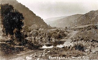
Whare Flat is a locality some 15 km to the northwest of Dunedin city centre, in the South Island of New Zealand. It is located at a widening of the Silver Stream's valley amid the foothills of the Silverpeaks.

Broadmeadows is a minor western suburb of Wellington, New Zealand. It is located to the north of Khandallah and south of Johnsonville. It is located 7 kilometres (4.3 mi) from the Wellington central business district. Despite its name suggesting that the area was once flat open fields, the suburb was created on steeply sloping hills and features the highest streets within Wellington City with a number of houses located more than 300m above sea level. Broadmeadows has a population of 1,635.

Southgate is a suburb of Wellington, New Zealand, in the Paekawakawa/Southern Ward. The main road is Buckley Road, which runs south from the point at which Mount Albert Road changes name to Houghton Bay Road.


