Glenville, New York

Last updated

Glenville, New York
Schenectady County New York incorporated and unincorporated areas Glenville highlighted.svg
Location in Schenectady County and the state of New York.
Coordinates: 42°55′45″N74°3′7″W / 42.92917°N 74.05194°W / 42.92917; -74.05194
Country United States
State New York
County Schenectady
Incorporated1821;203 years ago (1821)
Named for Alexander Lindsay Glen
Government
  Type Town board
  Town SupervisorChris Koetzle
Area
[1]
  Total50.73 sq mi (131.40 km2)
  Land49.24 sq mi (127.54 km2)
  Water1.49 sq mi (3.85 km2)
Elevation
715 ft (218 m)
Population
 (2020)
  Total29,326
  Density596/sq mi (230/km2)
Time zone UTC-5 (Eastern (EST))
  Summer (DST) UTC-4 (EDT)
ZIP code
12302, 12325
Area code 518
FIPS code 36-093-29366
Website www.townofglenville.org

Glenville is a town in Schenectady County, New York, United States. It was incorporated in 1821 from Schenectady. As of the 2020 census, the town population was 29,326. [2]

Contents

Including the village of Scotia, the town of Glenville encompasses the part of Schenectady County north of the Mohawk River.

History

Glenville is named after Alexander Lindsay Glen. Glen, who was a native of Scotland, acquired a large tract of land in the area in the 1650s. [3] [4] He named his manor at Scotia after his native country (Glen Sanders Mansion).

The Seeley Farmhouse was listed on the National Register of Historic Places in 1978, the Swart House and Tavern in 2007, and the Bishop Family Lustron House was listed the following year. [5] The Glenville District No. 5 Schoolhouse was listed in 2013. [6]

Geography

According to the United States Census Bureau, the town has a total area of 50.7 square miles (131.3 km2), of which 49.2 square miles (127.4 km2) is land and 1.5 square miles (3.9 km2), or 2.94%, is water. [7]

Demographics

Historical population
CensusPop.Note
1820 2,514
1830 2,494−0.8%
1840 3,06823.0%
1850 3,40911.1%
1860 3,192−6.4%
1870 2,973−6.9%
1880 2,746−7.6%
1890 2,468−10.1%
1900 3,01022.0%
1910 5,20172.8%
1920 7,03635.3%
1930 12,06971.5%
1940 13,34310.6%
1950 17,91234.2%
1960 25,70743.5%
1970 28,96912.7%
1980 28,519−1.6%
1990 28,7710.9%
2000 28,183−2.0%
2010 29,4804.6%
2020 29,326−0.5%
U.S. Decennial Census [8]

At the 2000 census, 28,183 people, 11,150 households, and 7,827 families living in the town. The population density was 565.0 inhabitants per square mile (218.1/km2). There were 11,582 housing units at an average density of 232.2 per square mile (89.7/km2). The racial makeup of the town was 97.35% White, 0.72% African American, 0.12% Native American, 0.89% Asian, 0.02% Pacific Islander, 0.14% from other races, and 0.75% from two or more races. Hispanic or Latino of any race were 1.20% of the population.

Of the 11,150 households, 30.9% had children under 18 living with them, 59.0% were married and living together, 8.4% had a female householder with no husband, and 29.8% were non-families. 26.0% of households were one person and 12.5% were 1 person 65 or older. The average household size was 2.44 and the average family size was 2.95.

The age distribution was 23.7% under 18, 5.0% from 18 to 24, 26.3% from 25 to 44, 26.1% from 45 to 64, and 18.9% 65 or older. The median age was 42 years. For every 100 females, there were 91.9 males. For every 100 females 18 or older, there were 86.8 males.

The median household income was $52,373 and the median family income was $62,599. Males had a median income of $42,992 versus $29,228 for females. The per capita income for the town was $24,795. 4.1% of the population and 2.5% of families were below the poverty line. Out of the people living in poverty, 5.2% were under 18 and 4.2% were 65 or older.

Communities and locations in Glenville

Economy

The town of Glenville is regarded as a bedroom community, with many residents finding employment at General Electric in adjacent Schenectady, various New York state offices in nearby Albany, and numerous Capital District corporations, educational institutions, and health care industries.

Education and recreation

The town is split among four public school districts; Scotia-Glenville, Burnt Hills-Ballston Lake, Amsterdam and Niskayuna. Glenville is also home to several parks and preserves.

Transportation

Mohawk Valley Airport is located three nautical miles (6 km) northwest of the central business district of Scotia. [9] [10] Schenectady County Airport is a joint civil-military airport located two nautical miles (3 km) north-northeast of Scotia.

Related Research Articles

<span class="mw-page-title-main">Schenectady County, New York</span> County in New York, United States

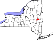
Schenectady County is a county in the U.S. state of New York. As of the 2020 census, the population was 158,061. The county seat is Schenectady. The name is from a Mohawk language word meaning "on the other side of the pine lands," a term that originally applied to Albany. The county is part of the Capital District region of the state.

<span class="mw-page-title-main">Gilmer County, West Virginia</span> County in West Virginia, United States

Gilmer County is a county in the U.S. state of West Virginia. As of the 2020 census, the population was 7,408, making it West Virginia's fifth-least populous county. Its county seat is Glenville. The county was formed in 1845 from parts of Lewis and Kanawha Counties, and named for Thomas Walker Gilmer, Governor of Virginia from 1840 to 1841. Gilmer was later a representative in the United States Congress and Secretary of the Navy in President John Tyler's cabinet.

<span class="mw-page-title-main">German Flatts, New York</span> Town in Herkimer County, New York, US

German Flatts is a town in Herkimer County, New York, United States. The population was 12,263 at the 2020 census down from 13,258 at the 2010 census.

<span class="mw-page-title-main">Charleston, New York</span> Town in Montgomery County, NY

Charleston is a town in Montgomery County, New York, United States. The population was 1,373 at the 2010 census. The town was named for Charles Van Epps, an early settler.

<span class="mw-page-title-main">Florida, Montgomery County, New York</span> Town in New York, United States

Florida is a town south of the Mohawk River in Montgomery County, New York, United States. The population was 2,696 in the 2010 United States Census. The town was named after the state of Florida. It is located in the eastern end of Montgomery County and is south of the City of Amsterdam, which it borders.

<span class="mw-page-title-main">Glen, New York</span> Town in New York, United States

Glen is a town in Montgomery County, New York, United States. The population was 2,507 at the 2010 census. The town was named after Jacob Glen, an early landowner.

<span class="mw-page-title-main">Palatine, New York</span> Town in New York, United States

Town of Palatine is a town in Montgomery County, New York, United States. It is located on the north side of the Mohawk River in the northwestern part of the county. The population was 3,240 at the 2010 census, the highest since the 1820s. The name is derived from the Palatinate in the Rhineland, the homeland of the Germans who were the earliest European settlers of this region. Administrative offices of the town are located in Palatine Bridge

<span class="mw-page-title-main">Whitestown, New York</span> Town in New York, United States

Whitestown is a town in Oneida County, New York, United States. The population was 18,667 at the 2010 census. The name is derived from Judge Hugh White, an early settler. The town is immediately west of Utica and the New York State Thruway passes across the town. The offices of the town of Whitestown are in the Village of Whitesboro.

<span class="mw-page-title-main">Ballston, New York</span> Town in New York, United States

Ballston is a town in Saratoga County, New York, United States. The population was 11,831 at the 2020 census. The name is derived from an early settler, Eliphalet Ball, a Presbyterian minister who relocated there from Westchester County, New York in 1770. The town is in the southern part of the county, and is north of Schenectady.

<span class="mw-page-title-main">Charlton, New York</span> Town in New York, United States

Charlton is a town in Saratoga County, New York, United States. The population was 3,954 at the 2000 census. The town is named after a notable physician.

<span class="mw-page-title-main">Clifton Park, New York</span> Town in New York, United States

Clifton Park is a suburban town in Saratoga County, New York, United States. It is the largest municipality in the county, with a 2020 population of 38,029, according to the 2020 census. The name is derived from an early land patent. The town is in the southern part of Saratoga County, approximately 12 miles (19 km) north of Albany, 7 miles (11 km) northeast of Schenectady, and 10 miles (16 km) south of Saratoga Springs.

<span class="mw-page-title-main">Halfmoon, New York</span> Town in New York, United States

Halfmoon is a town in Saratoga County, New York, United States. The population was 25,662 at the 2020 census. The town is apparently named for the shape of the lower elevation land north of the junction of the Hudson and Mohawk Rivers. It is also said to be named for Henry Hudson's ship, the Halve Maen.

<span class="mw-page-title-main">East Glenville, New York</span> Census-designated place in New York, United States

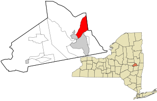
East Glenville is a hamlet in Schenectady County, New York, United States. The population was 6,616 at the 2010 census. The CDP includes the adjacent hamlet of Alplaus.

Pattersonville-Rotterdam Junction was a census-designated place (CDP) in Schenectady County, New York, United States. The population was 918 at the 2000 census. The area was not delineated as a CDP for the 2010 census.

<span class="mw-page-title-main">Scotia, New York</span> Village in New York, United States

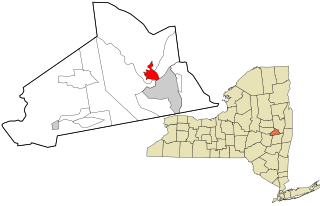
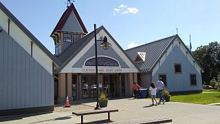
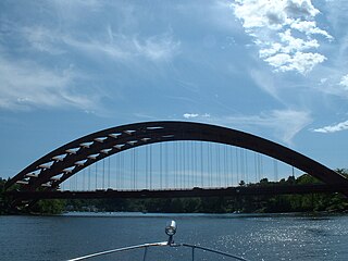
Scotia is a village in Schenectady County, New York, United States, incorporated in 1904. The population was 7,729 at the 2010 census. Scotia is part of the town of Glenville, and is connected with the city of Schenectady by the Western Gateway Bridge over the Mohawk River.

<span class="mw-page-title-main">Glenville, West Virginia</span> Town in West Virginia, United States

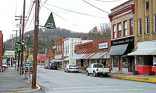
Glenville is a town in and the county seat of Gilmer County, West Virginia, United States, along the Little Kanawha River. The population was 1,128 at the 2020 census. It is the home of Glenville State University.

<span class="mw-page-title-main">Herkimer, New York</span> Town in New York, United States

Herkimer is a town in Herkimer County, New York, United States, southeast of Utica. It is named after Nicholas Herkimer. The population was 9,566 at the 2020 census, down from 10,175 in 2010.

<span class="mw-page-title-main">Amsterdam (town), New York</span> Town in New York, United States

Amsterdam is a town in Montgomery County, New York, United States. The population was 5,566 at the 2010 census. The town is named after Amsterdam, the capital of the Netherlands.

<span class="mw-page-title-main">Milton, Saratoga County, New York</span> Town in New York, United States

Milton is a town in Saratoga County, New York, United States. The population was 18,800 at the 2020 census. Some believe that the town was named after the poet, John Milton, while other sources state that it is a shortening of "Mill-town" for the early mill activity.

<span class="mw-page-title-main">Rotterdam, New York</span> Town in New York, United States

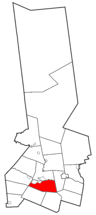
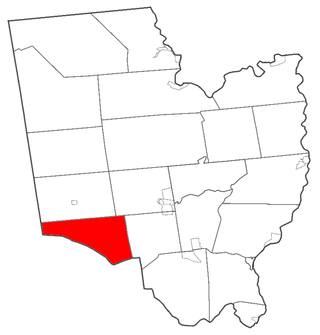
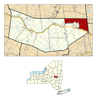
Rotterdam is a town in Schenectady County, New York, United States. The population was 30,523 at the 2020 census.

References

  1. "2016 U.S. Gazetteer Files". United States Census Bureau. Retrieved July 5, 2017.
  2. "Vital Information About the Town of Glenville" . Retrieved March 6, 2023.
  3. "Chapter V: The Township of Glenville". History of the City and County of Schenectady, New York. Schenectady County Public Library. 1913.
  4. Village of Scotia History
  5. "National Register Information System". National Register of Historic Places . National Park Service. March 13, 2009.
  6. "National Register of Historic Places Listings". Weekly List of Actions Taken on Properties: 05/19/13 through 05/23/13. National Park Service. May 30, 2014.
  7. "Geographic Identifiers: 2010 Demographic Profile Data (G001): Glenville town, Schenectady County, New York". United States Census Bureau . Retrieved July 3, 2012.
  8. "Census of Population and Housing". Census.gov. Retrieved June 4, 2015.
  9. "FAA Airport Master Record" (PDF). Federal Aviation Administration. May 7, 2009.
  10. "Mohawk Valley Airpark (K13)" (PDF). New York State Department of Transportation.