
Gateway Arch National Park is an American national park located in St. Louis, Missouri, near the starting point of the Lewis and Clark Expedition.
Herculaneum is a city in Jefferson County, Missouri, and is a suburb of St. Louis. The population was 4,273 at the 2020 United States Census. The City of Herculaneum was the first county seat of Jefferson County from January 1, 1819, to 1839. The city celebrated its bicentennial throughout 2008.

Crowley's Ridge is a geological formation that rises 250 to 550 feet (170 m) above the alluvial plain of the Mississippi embayment in a 150-mile (240 km) line from southeastern Missouri to the Mississippi River near Helena, Arkansas. It is the most prominent feature in the Mississippi Alluvial Plain between Cape Girardeau, Missouri, and the Gulf of Mexico.

Great River Bluffs State Park is a state park of Minnesota, United States, on the Mississippi River southeast of Winona. Originally known as O. L. Kipp State Park, it was renamed in the late 1990s to describe better its resources. The park preserves steep-sided bluffs rising 500 feet (150 m) above the river and the narrow valleys between them, which support rare and fragile plant communities. Two of the bluffs have received further protection under the Minnesota Scientific and Natural Areas program, which are known as King's and Queen's Bluff Scientific and Natural Area.

Daniel Dunklin was the fifth Governor of Missouri, serving from 1832 to 1836. He also served as the state's third Lieutenant Governor. Dunklin is considered the "Father of Public Schools" in Missouri. Dunklin was also the father-in-law of Missouri Lieutenant Governor Franklin Cannon. Dunklin County, in the Missouri bootheel, is named so in his honor.
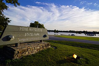
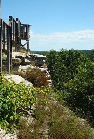
Pere Marquette State Park is an 8,050-acre (3,260 ha) protected area in southwestern Jersey County, Illinois, United States. It is located near the city of Grafton, Illinois, at the confluence of the Mississippi River and the Illinois River. The park is located on Illinois Route 100, which at this location is also part of both the Great River Road and the Meeting of the Great Rivers Scenic Byway. The park is operated and maintained by the Illinois Department of Natural Resources. The park is also part of the Confluence Greenway and is at the northwestern end of the 21.5-mile (34.6 km) Sam Vadalabene Bike Trail.

Washington State Park is a public recreation area covering 2,147 acres (869 ha) in Washington County in the central eastern part of the state of Missouri. It is located on Highway 21 about 14 miles (23 km) northeast of Potosi or 7 miles (11 km) southwest of De Soto on the eastern edge of the Ozarks. The state park is noted for its Native American rock carvings and for its finely crafted stonework from the 1930s.

Sam A. Baker State Park is a public recreation area encompassing 5,323 acres (2,154 ha) in the Saint Francois Mountains region of the Missouri Ozarks. The state park offers fishing, canoeing, swimming, camping, and trails for hiking and horseback riding. The visitor and nature center is housed in a historic building that was originally constructed as a stable in 1934.
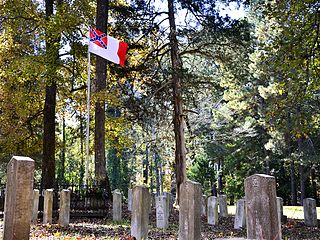
The Confederate Memorial State Historic Site is a state-owned property occupying approximately 135 acres (55 ha) near Higginsville, Missouri. From 1891 to 1950, the site was used as an old soldiers' home for veterans of the Confederate States Army after the American Civil War. The Missouri state government then took over operation of the site after the last veteran died in 1950, using it as a state park. In 1981, a cottage, a chapel, and the Confederate cemetery were listed on the National Register of Historic Places as the Confederate Chapel, Cemetery and Cottage. The chapel was moved from its original position in 1913, but was returned in 1978. It has a tower and a stained glass window. The cottage is a small wooden building, and the cemetery contains 723 graves. Within the cemetery is a monument erected by the United Daughters of the Confederacy which is modeled on the Lion of Lucerne. In addition to the cemetery and historic structures, the grounds also contain trails, picnic sites, and fishing ponds.
Trail of Tears State Park is a public recreation area covering 3,415 acres (1,382 ha) bordering the Mississippi River in Cape Girardeau County, Missouri. The state park stands as a memorial to those Cherokee Native Americans who died on the Cherokee Trail of Tears. The park's interpretive center features exhibits about the Trail of Tears as well as displays and specimens of local wildlife. An archaeological site in the park was added to the National Register of Historic Places in 1970.
Weldon Springs State Park is a Illinois state park; the primary 550-acre (220 ha) area is located near Clinton, Illinois, while a secondary area is located near Monticello, Illinois. The former centers on Salt Creek and the impoundment of a tributary, Weldon Springs, to form Weldon Spring Lake, a reservoir. It is supervised by the Illinois Department of Natural Resources.
Castle Rock State Park is an Illinois state park on 2,000 acres (809 ha) in Ogle County, Illinois, United States. A portion of the land was acquired by the "Friends of Our Native Landscape" in 1921.

Mastodon State Historic Site is a publicly owned, 431-acre (174 ha) archaeological and paleontological site with recreational features in Imperial, Missouri, maintained by the Missouri Department of Natural Resources, preserving the Kimmswick Bone Bed. Bones of mastodons and other now-extinct animals were first found here in the early 19th century. The area gained fame as one of the most extensive Pleistocene ice age deposits in the country and attracted scientific interest worldwide.

Nelson Dewey State Park is a 756-acre (306 ha) Wisconsin state park on the Mississippi River. The land was once part of the Stonefield estate of Nelson Dewey, the state's first governor.

The Dillard Mill State Historic Site is a privately owned, state-administered property on Huzzah Creek in Crawford County, Missouri, that preserves a water-powered gristmill. The 132-acre (53 ha) site has been operated as a state historic site by the Missouri Department of Natural Resources under a lease agreement with the L-A-D Foundation since 1975. The site was listed on the National Register of Historic Places in 2015.
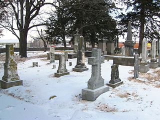
Jewell Cemetery State Historic Site is a publicly owned property in Columbia, Missouri, maintained as a state historic site by the Missouri Department of Natural Resources. Among the notable persons buried in the cemetery, which holds the remains of more than 40 descendants of George A. Jewell, are Missouri governor Charles Henry Hardin and the educator William Jewell. The property became part of the state parks system in 1970.
Morris State Park is a public recreation area consisting of 161 acres (65 ha) in Dunklin County, Missouri. The state park preserves a section of Crowley's Ridge, a unique geologic feature of southeast Missouri and northeast Arkansas. The state park offers a two-mile hiking trail along a portion of the "geologic oddity." The park is named for businessman Jim D. Morris, who donated the parcel to the state in 1999.

Sappington Cemetery State Historic Site is a Missouri state historic site located approximately five miles (8.0 km) southwest of Arrow Rock in Saline County. The cemetery houses the graves of John Sappington and two of his sons-in-law, Meredith Miles Marmaduke and Claiborne Fox Jackson, who each served as governor of Missouri before the American Civil War.
The Camp White Sulphur Springs Confederate Cemetery is an American Civil War cemetery in Arkansas. It is located northeast of the village of Sulphur Springs, also known as White Sulphur Springs, in Jefferson County.


