Union Covered Bridge State Historic Site

Last updated

Union Covered Bridge State Historic Site
Union Covered Bridge SHS from southeast 1.jpg
USA Missouri relief location map.svg
Red pog.svg
Location in Missouri
Usa edcp relief location map.png
Red pog.svg
Union Covered Bridge State Historic Site (the United States)
Location Monroe County, Missouri, United States
Coordinates 39°25′58″N92°06′09″W / 39.43278°N 92.10250°W / 39.43278; -92.10250 Coordinates: 39°25′58″N92°06′09″W / 39.43278°N 92.10250°W / 39.43278; -92.10250 [1]
Area1.24 acres (0.50 ha)
Elevation676 ft (206 m) [1]
Established1967
Visitors30,570(in 2020)
Governing bodyMissouri Department of Natural Resources
Website Union Covered Bridge State Historic Site
Union Covered Bridge
Nearest city Paris, Missouri [2]
Built1870 (1870)
Built byElliot, Joseph
NRHP reference No. 70000342
Added to NRHPJune 15, 1970

The Union Covered Bridge State Historic Site is a Missouri State Historic Site in Monroe County, Missouri. The covered bridge is a Burr-arch truss structure built in 1871 over the Elk Fork of the Salt River. It was almost lost to neglect in the 1960s, but was added to the state park system in 1967, the same year it was damaged by a flood. Repairs were made the next year, using timbers salvaged from another covered bridge that had been destroyed by the same flood. In 1970, it was closed to vehicular traffic and was added to the National Register of Historic Places. Further repairs were made in 1988, and it survived the Great Flood of 1993, only to be damaged by another flood in 2008 and later re-repaired. It is about 120 feet (37 m) or 125 feet (38 m) long, 12 feet (3.7 m) high, and 17.5 feet (5.3 m) wide.

Contents

History

The Monroe County government gave permission for bridge construction over the Elk Fork of the Salt River on April 8, 1870, [3] after two previous bridges at the site had failed. [4] Union Covered Bridge, named after the nearby Union Church, was then constructed in 1871 using locally-sourced oak wood, [5] opening on September 17. [6] It is about 120 feet (37 m) [5] or 125 feet (38 m) long [7] with a height of 12 feet (3.7 m) and width of 17.5 feet (5.3 m) [4] and was originally on the road between Paris and Fayette. [8] Joseph Elliott was the builder. [9] Construction originally cost $5,500 (equivalent to $124,407in 2021). [3]

Locals raised $1,000 (equivalent to $9,068in 2021) to preserve the bridge in 1961, [10] but in the late 1960s, the bridge was almost a victim of neglect. [5] In 1967, the bridge was damaged by a flood, with parts of the bridge's siding being swept away. [3] Earlier that year, the Missouri General Assembly had passed a law to bring all remaining covered bridges into the state into the state parks system. [6] It was later repaired using salvaged timbers from the Mexico Covered Bridge, [5] which had been destroyed in the same flood. Further restoration occurred in 1968, at a cost of $25,000 (equivalent to $194,809in 2021). It was closed to vehicular traffic in 1970 after it was damaged, likely by a truck bearing a heavy load that had detoured away from a low-water crossing. [3] The bridge was listed on the National Register of Historic Places on June 15, 1970. [11] Repairs were made in 1988, [6] and it survived flooding during the Great Flood of 1993. [8]

A flood in 2008 damaged the bridge, with parts of the bridge's structure being knocked loose. [12] In 2011, the state of Missouri received $145,000 from the federal government to repair 2008 flood damage at Union Covered Bridge and to do work at the Sandy Creek Covered Bridge. [13] Restoration was completed in 2019. [5] The site is sometimes used for weddings and baptisms. [4] Site management is provided by Mark Twain State Park. The state historic site covers 1.24 acres (0.50 ha) and contains 0.2 miles (0.32 km) of roadway. In 2020, it was visited by 30,570 people and had a budget of $4,680. [14]

Design

The Union Covered Bridge is the only Burr-arch truss covered bridge still extant in Missouri; the other three covered bridges remaining in Missouri are examples of the Howe truss. The Burr design uses multiple king posts and an arch to support the bridge's truss. The Union Covered Bridge specifically has two arches on either side of the bridge. [5] The design is slightly bowed to the upstream, which helps stabilize it in flood conditions. [8] The bridge has been described as barn-like, and local legend claims that the appearance helped farm animals be more willing to cross it. [7] In 1995, the interior was reported to be covered in graffiti. [9] The components of the bridge are mainly held together with treenails, with only a few iron fasteners for additional support. The roof is covered with wood shingles. [4] The bridge is oriented east-west. [2]

Related Research Articles

<span class="mw-page-title-main">Jackson's Sawmill Covered Bridge</span> Wooden truss covered bridge

The Jackson's Sawmill Covered Bridge or Eichelberger's Covered Bridge is a covered bridge that spans the West Branch of the Octoraro Creek in Lancaster County, Pennsylvania. A county-owned and maintained bridge, its official designation is the West Octoraro #1 Bridge. The bridge is purportedly the only covered bridge in the county that is not built perpendicular to the stream it crosses due to the placement of the sawmill on one side of the bridge and the rock formations faced by the builders on the other side.

<span class="mw-page-title-main">Siegrist's Mill Covered Bridge</span> Bridge in Pennsylvania, United States

The Siegrist's Mill Covered Bridge is an 88-foot (27 m), Burr Arch Truss covered bridge over Chiques Creek between Rapho and West Hempfield townships, Lancaster County in U.S. state of Pennsylvania. Owned and maintained by the county, its official designation is the Big Chiques #6 Bridge.

<span class="mw-page-title-main">Pinetown Bushong's Mill Covered Bridge</span> Bridge in Pennsylvania, United States

The Pinetown Bushong's Mill Covered Bridge is a covered bridge that spans the Conestoga River in Lancaster County, Pennsylvania, United States. A county-owned and maintained bridge, its official designation is the Big Conestoga #6 Bridge. The bridge is also known as Pinetown Covered Bridge, Nolte's Point Mill Bridge and Bushong's Mill Bridge.

<span class="mw-page-title-main">Bollinger Mill State Historic Site</span>

The Bollinger Mill State Historic Site is a state-owned property preserving a mill and covered bridge that pre-date the American Civil War in Burfordville, Cape Girardeau County, Missouri. The park was established in 1967 and offers mill tours and picnicking. It is managed by the Missouri Department of Natural Resources. It includes the Burfordville Covered Bridge, which is listed on the National Register of Historic Places.

<span class="mw-page-title-main">West Union Covered Bridge (Indiana)</span> Place in Indiana listed on National Register of Historic Places

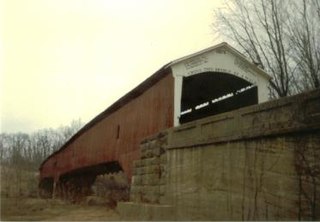
The West Union Covered Bridge formerly carried Tow Path Road over Sugar Creek north-northeast of Montezuma, Indiana. The two-span Burr Arch Truss covered bridge structure was built by Joseph J. Daniels in 1876. It is notable for being the longest standing covered bridge in Parke County, and one of the nation's best-preserved examples of the Burr truss.

<span class="mw-page-title-main">Cogan House Covered Bridge</span> Covered bridge in Pennsylvania, US

The Cogan House Covered Bridge is a Burr arch truss covered bridge over Larrys Creek in Cogan House Township, Lycoming County, in the U.S. state of Pennsylvania. It was built in 1877 and is 94 feet 2 inches (28.7 m) long. The bridge was placed on the National Register of Historic Places in 1980, and had a major restoration in 1998. The Cogan House bridge is named for the township and village of Cogan House, and is also known by at least four other names: Buckhorn, Larrys Creek, Day's, and Plankenhorn.

<span class="mw-page-title-main">Sonestown Covered Bridge</span> Covered bridge in Davidson Township, Sullivan County, Pennsylvania

The Sonestown Covered Bridge is a covered bridge over Muncy Creek in Davidson Township, Sullivan County, Pennsylvania built around 1850. It is 110 ft (34 m) long and was placed on the National Register of Historic Places (NRHP) in 1980. It is named for the nearby unincorporated village of Sonestown in Davidson Township, and is also known as the Davidson Covered Bridge. It was built to provide access to a grist mill which operated until the early 20th century.

<span class="mw-page-title-main">Forksville Covered Bridge</span> Bridge over Loyalsock Creek, Pennsylvania

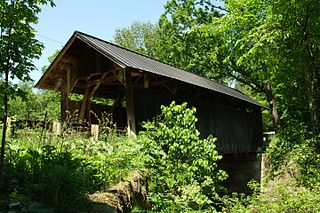
The Forksville Covered Bridge is a Burr arch truss covered bridge over Loyalsock Creek in the borough of Forksville, Sullivan County, in the U.S. state of Pennsylvania. It was built in 1850 and is 152 feet 11 inches (46.61 m) in length. The bridge was placed on the National Register of Historic Places in 1980. The Forksville bridge is named for the borough it is in, which in turn is named for its location at the confluence or "forks" of the Little Loyalsock and Loyalsock Creeks.

<span class="mw-page-title-main">Burkeville Covered Bridge</span> United States historic place

The Burkeville Covered Bridge is a historic covered bridge, carrying Main Poland Road over the South River in Conway, Massachusetts. Probably built in 1870, it is a regionally rare example of a multiple kingrod bridge with iron tensioning verticals, and one of a few 19th century covered bridges to survive in Massachusetts. It was listed on the National Register of Historic Places in 1988.

<span class="mw-page-title-main">Arthur A. Smith Covered Bridge</span> United States historic place

The Arthur A. Smith Covered Bridge is a historic covered bridge, carrying Lyonsville Road across the North River in Colrain, Massachusetts. Built in 1869, it is the only Burr truss bridge in the state, and is one of a few 19th century covered bridges in the state. It was listed on the National Register of Historic Places in 1983.

<span class="mw-page-title-main">Grist Mill Covered Bridge</span> Bridge in Cambridge, Vermont

The Grist Mill Covered Bridge, also known as the Scott Covered Bridge, the Bryant Covered Bridge, and the Canyon Covered Bridge, is a covered bridge that carries Canyon Road across the Brewster River, off Vermont Route 108 in Cambridge, Vermont. Built in the 19th century, it is one of a small number of surviving Burr arch truss bridges in the state, and is one of three left in Cambridge. It was listed on the National Register of Historic Places in 1974.

<span class="mw-page-title-main">Cold River Bridge (Langdon, New Hampshire)</span> United States historic place

The Cold River Bridge, also known as McDermott Bridge, is a historic wooden covered bridge spanning the Cold River near Crane Brook Road in Langdon, New Hampshire, USA. Built in 1869, it is one of the state's few surviving 19th-century covered bridges. It was listed on the National Register of Historic Places in 1973. It is closed to vehicular traffic.

<span class="mw-page-title-main">Bath Covered Bridge</span> United States historic place

The Bath Covered Bridge is a historic covered bridge over the Ammonoosuc River off US 302 and NH 10 in Bath, New Hampshire. Built in 1832, it is one of the state's oldest surviving covered bridges. It was listed on the National Register of Historic Places in 1976, and underwent a major rehabilitation in the 2010s.

<span class="mw-page-title-main">DXN Bridge</span> United States historic place

The DXN Bridge over the Little Missouri River is one of a group of thirty-one bridges in Wyoming that were collectively listed on the National Register of Historic Places as excellent examples of steel truss bridges of the early 20th century. The DXN Bridge is located in Crook County, Wyoming. It is a single-span of about 72 feet (22 m), an 8-bay Pratt pony truss on Crook County Road 18-200. It was built about 1920. The bridge is unique in lacking inclined end posts.

<span class="mw-page-title-main">Sachs Covered Bridge</span> Bridge in Pennsylvania, United States

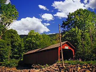
The Sachs Covered Bridge, also known as Sauck's Covered Bridge and Waterworks Covered Bridge, is a 100-foot (30 m), Town truss covered bridge over Marsh Creek between Cumberland and Freedom Townships, Adams County in the U.S. state of Pennsylvania. The bridge was also known as the Sauches Covered Bridge at the time of the Battle of Gettysburg. It was listed on the National Register of Historic Places in 1980.

<span class="mw-page-title-main">Quinlan's Covered Bridge</span> Bridge in Charlotte, Vermont

Quinlan's Covered Bridge, also called the Lower Covered Bridge, and Sherman Covered Bridge is a wooden covered bridge that crosses Lewis Creek in Charlotte, Vermont on Monkton Road. It was listed on the National Register of Historic Places in 1974. It is one of nine 19th-century Burr arch covered bridges in the state.

<span class="mw-page-title-main">Great Eddy Covered Bridge</span> Bridge in Waitsfield, Vermont

The Great Eddy Covered Bridge, also called the Big Eddy Covered Bridge or Waitsfield Covered Bridge, is a wooden covered bridge that crosses the Mad River in Waitsfield, Vermont on Bridge Street. Built in 1833, it is one of Vermont's oldest covered bridges. It was listed on the National Register of Historic Places in 1974.

<span class="mw-page-title-main">Seguin Covered Bridge</span> Bridge in Charlotte, Vermont

The Seguin Covered Bridge, also called the Upper Covered Bridge and the Sequin Covered Bridge, is a wooden covered bridge that crosses Lewis Creek in Charlotte, Vermont on Roscoe Road. It was built about 1850, and is a distinctive variant of a Burr arch design. It was listed on the National Register of Historic Places in 1974.

<span class="mw-page-title-main">Taftsville Covered Bridge</span> Bridge in Woodstock, Vermont

The Taftsville Covered Bridge is a timber-framed covered bridge which spans the Ottauquechee River in the Taftsville village of Woodstock, Vermont, in the United States. Built in 1836 and exhibiting no influence from patented bridge designs, it is among the oldest remaining covered bridges both in Vermont and the nation as a whole.

<span class="mw-page-title-main">West Sixth Street Bridge</span> Historic bridge in Austin, Texas

The West Sixth Street Bridge is a historic stone arch bridge in downtown Austin, Texas. Built in 1887, the bridge is one of the state's oldest masonry arch bridges. It is located at the site of the first bridge in Austin, carrying Sixth Street across Shoal Creek to link the western and central parts of the old city. The bridge was added to the National Register of Historic Places in 2014.

References

  1. 1 2 "Union Bridge". Geographic Names Information System . United States Geological Survey, United States Department of the Interior.
  2. 1 2 Piggott, Charla A. (March 3, 1970). "National Register of Historic Places Inventory – Nomination Form (Union Covered Bridge)" (PDF). Missouri State Parks. Retrieved 20 April 2022.
  3. 1 2 3 4 Keller, James E. (November 3, 1976). "Missouri's Covered Bridges". St. Louis Post-Dispatch. Retrieved 20 April 2022.
  4. 1 2 3 4 "At Union Covered Bridge State Historic Site A Relic of the Past". Missouri State Parks. Retrieved 20 April 2022.
  5. 1 2 3 4 5 6 Hahn, Valerie Schremp (July 4, 2021). "Undercover, Over Water: Historic Covered Bridges in Missouri and Illinois Tell Stories of Long-Ago Journeys". St. Louis Post-Dispatch. Retrieved 20 April 2022.
  6. 1 2 3 Emery, Tom (January 14, 2018). "Missouri's Remaining Covered Bridges Speak to Bygone Era". Hannibal Courier-Post. Retrieved 20 April 2022.
  7. 1 2 Well, Tom (April 18, 1982). "Long Way is Fine Way to Kansas City". St. Louis Post-Dispatch. Retrieved 20 April 2022.
  8. 1 2 3 Fisher, James J. (August 27, 1993). "The Old-Timers Were a Little Wiser than We Thought". The Kansas City Star. Retrieved 20 April 2022.
  9. 1 2 Hughes, Chuck (October 8, 1995). "The Bridges of Missouri Counties". St. Joseph News-Press. Retrieved 20 April 2022.
  10. "$1,000 Is Pledged to Preserve Union Covered Bridge". Moberly Monitor-Index. October 27, 1961. Retrieved 20 April 2022.
  11. "National Register Database and Research". National Park Service. Retrieved 20 April 2022.
  12. "Federal Grant Will Help Preserve Missouri's Covered Bridges". The Douglas County Herald. July 14, 2011. Retrieved 20 April 2022.
  13. "Mo. Gets Federal Money for Covered Bridges". The Daily Journal. July 16, 2011. Retrieved 20 April 2022.
  14. "Union Covered Bridge State Historic Site" (PDF). Missouri State Parks. Retrieved 20 April 2022.