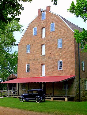
Zalma, once known as "Bollinger's Mill",is an unincorporated community and census-designated place (CDP) on the banks of the winding Castor River at a point where the river makes a horseshoe bend in southern Bollinger County in southeast Missouri,United States. When the railroad moved to town,the name Bollinger's Mill was changed to Zalma,after railroad worker Zalma Block. Zalma is also said to come from a Native American word meaning "the end." As of the 2020 U.S. Census,Zalma had a population of 73.

The Jefferson Barracks Bridge,officially the Jefferson Barracks Memorial Arch Bridge,is a pair of bridges across the Mississippi River on the south side of St. Louis,Missouri metropolitan area. Each bridge is 3,998 feet (1,219 m) long with a 909-foot (277 m) long arch bridge spanning the shipping channel. The northern bridge was built in 1983,and the southern opened in 1992. A delay occurred during the construction of the southern bridge when a crane dropped a section of it into the river and it had to be rebuilt.
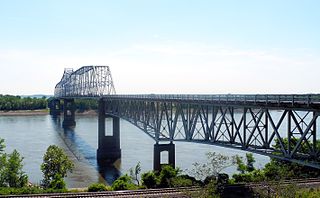
The Chester Bridge is a continuous truss bridge connecting Missouri's Route 51 with Illinois Route 150 across the Mississippi River between Perryville,Missouri and Chester,Illinois. It is the only motor-traffic bridge spanning the Mississippi River between St. Louis and Cape Girardeau,Missouri.

Burfordville is an unincorporated community in western Cape Girardeau County,Missouri,United States,on the banks of the Whitewater River. It is located five miles west of Jackson on Route 34. Bufordville is part of the Cape Girardeau–Jackson,MO-IL Metropolitan Statistical Area.

The Cape Girardeau Bridge was a continuous through truss bridge connecting Missouri's Route 34 with Illinois Route 146 across the Mississippi River between Cape Girardeau,Missouri,and East Cape Girardeau,Illinois. It was replaced in 2003 with the Bill Emerson Memorial Bridge.
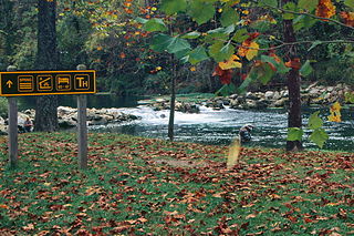
Bennett Spring State Park is a public recreation area located in Bennett Springs,Missouri,twelve miles (19 km) west of Lebanon on Highway 64 in Dallas and Laclede counties. It is centered on the spring that flows into the Niangua River and gives the park its name. The spring averages 100 million gallons of daily flow. The park offers fly fishing,camping,canoeing,hiking,and other activities.

The Bedell Bridge was a Burr truss covered bridge that spanned the Connecticut River between Newbury,Vermont and Haverhill,New Hampshire. Until its most recent destruction in 1979,it was,with a total length of 382 feet (116 m),the second-longest covered bridge in the United States. The bridge was divided into two spans of roughly equal length,and rested on a central pier and shore abutments constructed from mortared rough stone. The eastern abutment has been shored up by the addition of a concrete footing. The bridge was 23 feet (7.0 m) wide,with a roadway width of 18.5 feet (5.6 m). Because the state line is the western low-water mark of the Connecticut River,most of the bridge was in New Hampshire;only the western abutment is in Vermont.

The Casselman Bridge is an historic transportation structure on the Casselman River,located immediately east of Grantsville in Garrett County,Maryland. The bridge was built in 1813-1814 as part of the National Road. Historic markers posted at each end read:
Erected 1813 by David Shriver,Jr.,
Sup't of the "Cumberland Road". This 80 foot span
was the largest stone arch in America
at the time. It was continuously
used from 1813 to 1933.
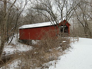
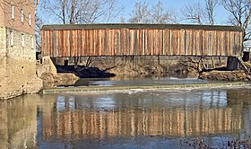
Sandy Creek Covered Bridge State Historic Site is a publicly owned property in Jefferson County,Missouri,administered by the Missouri Department of Natural Resources,preserving the Sandy Creek Covered Bridge. The bridge is one of four remaining covered bridges in Missouri,which once numbered about 30. It is a relatively rare example of a Howe truss bridge,one of three in Missouri. The covered bridge is named for Sandy Creek,which it crosses,and was added to the National Register of Historic Places in 1970.
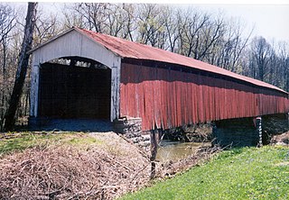
Locust Creek Covered Bridge State Historic Site is a publicly owned property in Linn County,Missouri,maintained as a state historic site by the Missouri Department of Natural Resources. Also called the Linn County Bridge,the covered bridge is located about 3 miles (4.8 km) east of Meadville,Missouri. At a length of 151 feet (46 m) with a width of 16 ft 8 in (5.08 m) it is the longest of the four remaining covered bridges in the state of Missouri. It was listed on the National Register of Historic Places in 1970.

The Union Covered Bridge State Historic Site is a Missouri State Historic Site in Monroe County,Missouri. The covered bridge is a Burr-arch truss structure built in 1871 over the Elk Fork of the Salt River. It was almost lost to neglect in the 1960s,but was added to the state park system in 1967,the same year it was damaged by a flood. Repairs were made the next year,using timbers salvaged from another covered bridge that had been destroyed by the same flood. In 1970,it was closed to vehicular traffic and was added to the National Register of Historic Places. Further repairs were made in 1988,and it survived the Great Flood of 1993,only to be damaged by another flood in 2008 and later re-repaired. It is about 120 feet (37 m) or 125 feet (38 m) long,12 feet (3.7 m) high,and 17.5 feet (5.3 m) wide.

The Glenn House is a historic home located at Cape Girardeau,Missouri. It was built in 1883,and is a two-story,Late Victorian style painted brick dwelling. It is topped by cross-gabled and pyramidal roofs. It features a verandah with Tuscan order columns,turret,and oriel window. The house has been restored and open to the public by the Historical Association of Greater Cape Girardeau,Inc.

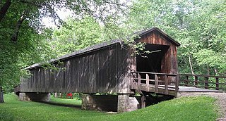
The Grist Mill Covered Bridge,also known as the Scott Covered Bridge,the Bryant Covered Bridge,and the Canyon Covered Bridge,is a covered bridge that carries Canyon Road across the Brewster River,off Vermont Route 108 in Cambridge,Vermont. Built in the 19th century,it is one of a small number of surviving Burr arch truss bridges in the state,and is one of three left in Cambridge. It was listed on the National Register of Historic Places in 1974.

The Bement Covered Bridge is a historic wooden covered bridge on Center Road over the Warner River in Bradford,New Hampshire. A Long-truss bridge,it was built in 1854,and is one of New Hampshire's small number of surviving 19th-century covered bridges. It was listed on the National Register of Historic Places in 1976.

Duck Creek Aqueduct,also known as the Metamora Aqueduct and Whitewater Canal Aqueduct,is a historic aqueduct carrying the Whitewater Canal over Duck Creek in Metamora Township,Franklin County,Indiana. Built in 1846,it is the only surviving covered wood aqueduct in the United States. The aqueduct was listed on the National Register of Historic Places and designated a National Historic Landmark in 2014. It is located in the Whitewater Canal Historic District and part of the Metamora Historic District.

Brownsville Covered Bridge was a historic long truss covered bridge located at Brownsville,Union County,Indiana. It was built between 1837 and 1840,and was a single span covered timber bridge. It measured 182 feet (55 m) long and 21 feet 6 inches (6.55 m) wide. The bridge spanned the East Fork of the Whitewater River.
Shields' Mill Covered Bridge,also known as Shieldstown Covered Bridge,is a historic covered bridge located in Brownstown Township and Hamilton Township,Jackson County,Indiana. It spans the White River and is a multiple kingpost Burr Arch Truss bridge. It was built 1876,and is a two-span wooden bridge resting on cut limestone pier and abutments. It measures 365 feet,6 inches,long. The bridge was closed to traffic in 1970.

Old Appleton Bridge is a historic Pratt Truss Iron Bridge located at Old Appleton,Cape Girardeau County and Perry County,Missouri. It was built in 1879,and consists of a wrought iron,pin-connected,Pratt through truss main span,with two pin-connected,three panel Pratt pony-truss approach spans. It rests on limestone block masonry piers. The total length of the bridge is 161 feet (49 m).
Crooked Creek is a stream in Bollinger and Cape Girardeau counties of southeast Missouri. It is a tributary to the Headwater Diversion Channel.