Reynolds County is a county located in the Ozark Foothills Region in the Lead Belt of Missouri. As of the 2020 census, the population was 6,096. Its county seat is Centerville. The county was officially organized on February 25, 1845, and was named in honor of former Governor of Missouri Thomas Reynolds.

Iron County is a county located in the Lead Belt region in the U.S. state of Missouri. As of the 2020 census, the population was 9,537. The largest city and county seat is Ironton. Iron County was officially organized on February 17, 1857, and was named after the abundance of iron ore found within its borders.
The United States federal executive departments are the principal units of the executive branch of the federal government of the United States. They are analogous to ministries common in parliamentary or semi-presidential systems but they are led by a head of government who is also the head of state. The executive departments are the administrative arms of the President of the United States. There are currently 15 executive departments.

Route 66 State Park is a public recreation area located on the Meramec River at the site of the former town of Times Beach, Missouri. The state park encompasses 419 acres (170 ha) one mile (1.6 km) east of Eureka.

The Katy Trail State Park is a state park in the U.S. state of Missouri that contains the Katy Trail, the country's longest continuous recreational rail trail. It runs 240 miles (390 km), largely along the northern bank of the Missouri River, in the right-of-way of the former Missouri–Kansas–Texas Railroad. Open year-round from sunrise to sunset, it serves hikers, joggers, and cyclists. Its hard, flat surface is of "limestone pug".

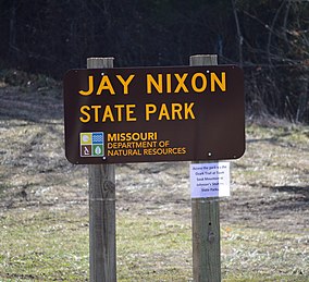
Jeremiah Wilson "Jay" Nixon is an American lawyer and politician who served as the 55th Governor of Missouri from 2009 to 2017. A member of the Democratic Party, he was first elected to the governorship in 2008 and reelected in 2012. Prior to his tenure as Missouri Governor, he served as the 40th Missouri Attorney General from 1993 to 2009. After leaving public office he joined the Dowd Bennett law firm in St. Louis. As of 2023, he is the most recent Democrat to serve as the Governor of Missouri.

Ha Ha Tonka State Park is a public recreation area encompassing over 3,700 acres (1,500 ha) on the Niangua arm of the Lake of the Ozarks, about five miles south of Camdenton, Missouri, in the United States. The state park's most notable feature is the ruins of Ha Ha Tonka, an early 20th-century stone mansion that was modeled after European castles of the 16th century.
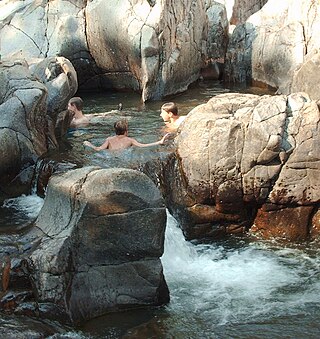
Johnson's Shut-Ins State Park is a public recreation area covering 8,781 acres (3,554 ha) on the East Fork Black River in Reynolds County, Missouri. The state park is jointly administered with adjoining Taum Sauk Mountain State Park, and together the two parks cover more than sixteen thousand acres in the St. Francois Mountains region of the Missouri Ozarks.

Washington State Park is a public recreation area covering 2,147 acres (869 ha) in Washington County in the central eastern part of the state of Missouri. It is located on Highway 21 about 14 miles (23 km) northeast of Potosi or 7 miles (11 km) southwest of DeSoto on the eastern edge of the Ozarks. The state park is noted for its Native American rock carvings and for its finely crafted stonework from the 1930s.

Babler State Park is a state-managed public recreation area located in the northwest section of the city of Wildwood, Missouri. A large bronze statue of Dr. Babler greets park visitors. The state park's 2,441 acres (988 ha) offer opportunities for hiking, picnicking, bicycling, horseback riding, and camping. The park was added to the National Register of Historic Places in 1985.

Sam A. Baker State Park is a public recreation area encompassing 5,323 acres (2,154 ha) in the Saint Francois Mountains region of the Missouri Ozarks. The state park offers fishing, canoeing, swimming, camping, and trails for hiking and horseback riding. The visitor and nature center is housed in a historic building that was originally constructed as a stable in 1934.
Bennett Spring State Park is a public recreation area located in Bennett Springs, Missouri, twelve miles (19 km) west of Lebanon on Highway 64 in Dallas and Laclede counties. It is centered on the spring that flows into the Niangua River and gives the park its name. The spring averages 100 million gallons of daily flow. The park offers fly fishing, camping, canoeing, hiking, and other activities.

The Missouri–Kansas–Texas Bridge is a former rail bridge across the Missouri River at Boonville, Missouri, where it connects Howard and Cooper counties. In 2010, the bridge was acquired by the city of Boonville from the Union Pacific Railroad. The city plans to incorporate it into the 225-mile Katy Trail bicycle trail.

Lake of the Ozarks State Park is a Missouri state park on the Grand Glaize Arm of the Lake of the Ozarks and is the largest state park in the state. This is also the most popular state park in Missouri, with over 2.5 million visitations in 2017.

Graham Cave State Park is a state park in the U.S. state of Missouri consisting of 369 acres (149 ha) located in Montgomery County. The park's namesake, Graham Cave, is a cave in St. Peter sandstone with an entrance 120 feet (37 m) wide and 60 feet (18 m) high and an extent of about 100 feet (30 m) into the hillside. The cave protects an historically important Pre-Columbian archaeological site dating back to as early as 10,000 years ago. Visitors are allowed up to the entrance of the cave where interpretive signs point out significant discoveries. The park includes the 82-acre (33 ha) Graham Cave Glades Natural Area which protects an area of sandstone and dolomite glades with a rich diversity of glade species. The park is adjacent to Interstate 70 from which the entrance to the cave can be glimpsed during foliage-free months.
Knob Noster State Park is a public recreation area covering 3,934 acres (1,592 ha) in Johnson County, Missouri, in the United States. The state park bears the name of the nearby town of Knob Noster, which itself is named for one of two small hills or "knobs" that rise up in an otherwise flat section of Missouri. Noster is a Latin adjective meaning "our"—therefore, Knob Noster translates as "our hill." A local Indian belief stated that the hills were "raised up as monuments to slain warriors." The park offers year-round camping, hiking, and fishing and is managed by the Missouri Department of Natural Resources.

Rock Bridge Memorial State Park is a geological preserve and public recreation area encompassing 2,273 acres (920 ha), five miles (8.0 km) south of Columbia in Boone County, Missouri off of Missouri Route 163.
The Rock Island Spur of Katy Trail State Park is a state park in the U.S. state of Missouri that is 47-mile (76 km) rails to trails hiking and biking trail. Work on the trail was completed and the trail was opened on December 10, 2016. The trail provides residents of the Kansas City region direct trail access to the 240 mi (390 km) Katy Trail State Park, the longest rails to trails trail in the U.S. The Rock Island Trail uses "abandoned" right-of-way of the Chicago, Rock Island and Pacific Railroad between Pleasant Hill in Cass County and Windsor in Henry County where it meets the Katy Trail.

Eleven Point State Park is one of three new Missouri state parks announced in 2016 that is awaiting developments and is unopened. The 4,167 acre state park is located mostly on lands of the historic Pigman Ranch near Riverton in Oregon County on Eleven Point River in the Ozarks of southern Missouri. Plans called for hiking and walking trails, camping, fishing, picnicking, birdwatching, and nature study to be available. In August 2017, the administration of Governor Eric Greitens closed the park indefinitely.
Ozark Mountain State Park is an undeveloped public recreation area covering 1,011 acres (409 ha) in Taney County, Missouri. The state park is closed pending public input on future uses of the land. It was one of three new parks announced by Governor Jay Nixon in December 2016. It shares a border with the Ruth and Paul Henning Conservation Area and is traversed by more than two miles of Roark Creek, including a stretch of the three-mile-long East Fork Roark Creek. The site includes a one-room schoolhouse that served the former community of Garber.