
Starved Rock State Park is a state park in the U.S. state of Illinois, characterized by the many canyons within its 2,630 acres (1,064 ha). Located just southeast of the village of Utica, in Deer Park Township, LaSalle County, Illinois, along the south bank of the Illinois River, the park hosts over two million visitors annually, the most for any Illinois state park.
The Illinois Historic Preservation Division, formerly Illinois Historic Preservation Agency, is a governmental agency of the U.S. state of Illinois, and is a division of the Illinois Department of Natural Resources. It is tasked with the duty of maintaining State-owned historic sites, and maximizing their educational and recreational value to visitors or on-line users. In addition, it manages the process for applications within the state for additions to the National Register of Historic Places.

Sanilac Petroglyphs Historic State Park is a state park in the U.S. state of Michigan. The park, also known as ezhibiigadek asin consists of 240 acres (97 ha) in Greenleaf Township, Sanilac County, in Michigan's Thumb. It contains the largest collection of Native American petroglyphs in Michigan. The carvings were created in the pre-Columbian era and represent aspects of Native American spirituality. An interpretive hiking trail within the park passes along the nearby Cass River.

Washington State Park is a public recreation area covering 2,147 acres (869 ha) in Washington County in the central eastern part of the state of Missouri. It is located on Highway 21 about 14 miles (23 km) northeast of Potosi or 7 miles (11 km) southwest of De Soto on the eastern edge of the Ozarks. The state park is noted for its Native American rock carvings and for its finely crafted stonework from the 1930s.
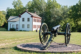
Battle of Athens State Historic Site is an historic battlefield and state park located in Clark County, Missouri, along the banks of the Des Moines River. It is the site of the Battle of Athens, fought in 1861 during the American Civil War. The site serves as an open-air museum interpreting the battle and its aftermath. It is one of the northernmost places in the state.
The Battle of Lexington State Historic Site is a state-owned property located in the city of Lexington, Missouri. The site was established in 1958 to preserve the grounds where an American Civil War battle took place in 1861 between Confederate troops led by Major-General Sterling Price and federal troops led by Colonel James A. Mulligan. The site offers a short battlefield loop trail, picnicking, and tours of the battlegrounds and Oliver Anderson mansion.
Clark's Hill/Norton State Historic Site is located on the eastern edge of Jefferson City Missouri, United States. The park preserves one of the campsites used by the Lewis and Clark Expedition as well as a lookout point from which William Clark viewed the confluence of the Osage and Missouri rivers. American Indian burial mounds may also be seen at the site. The site was donated to the state by Jefferson City residents William and Carol Norton in 2002 and opened to the public in 2004.
Trail of Tears State Park is a public recreation area covering 3,415 acres (1,382 ha) bordering the Mississippi River in Cape Girardeau County, Missouri. The state park stands as a memorial to those Cherokee Native Americans who died on the Cherokee Trail of Tears. The park's interpretive center features exhibits about the Trail of Tears as well as displays and specimens of local wildlife. An archaeological site in the park was added to the National Register of Historic Places in 1970.

Town Creek Indian Mound is a prehistoric Native American archaeological site located near present-day Mount Gilead, Montgomery County, North Carolina, in the United States. The site, whose main features are a platform mound with a surrounding village and wooden defensive palisade, was built by the Pee Dee, a South Appalachian Mississippian culture people that developed in the region as early as 980 CE. They thrived in the Pee Dee River region of North and South Carolina during the Pre-Columbian era. The Town Creek site was an important ceremonial site occupied from about 1150—1400 CE. It was abandoned for unknown reasons. It is the only ceremonial mound and village center of the Pee Dee located within North Carolina.

Mastodon State Historic Site is a publicly owned, 431-acre (174 ha) archaeological and paleontological site with recreational features in Imperial, Missouri, maintained by the Missouri Department of Natural Resources, preserving the Kimmswick Bone Bed. Bones of mastodons and other now-extinct animals were first found here in the early 19th century. The area gained fame as one of the most extensive Pleistocene ice age deposits in the country and attracted scientific interest worldwide.

The Wisconsin Heights Battlefield is an area in Dane County, Wisconsin, where the penultimate battle of the 1832 Black Hawk War occurred. The conflict was fought between the Illinois and Michigan Territory militias and Sauk chief Black Hawk and his band of warriors, who were fleeing their homeland following the Fox Wars. The Wisconsin Heights Battlefield is the only intact battle site from the Indian Wars in the U.S. Midwest. Today, the battlefield is managed and preserved by the state of Wisconsin as part of the Lower Wisconsin State Riverway. In 2002, it was listed on the U.S. National Register of Historic Places.

Watkins Mill in Lawson, Missouri, United States, is a preserved woolen mill dating to the mid-19th century. The mill is protected as Watkins Woolen Mill State Historic Site, which preserve its machinery and business records in addition to the building itself. It was designated a National Historic Landmark and added to the National Register of Historic Places in 1966 in recognition for its remarkable state of preservation. The historic site is the centerpiece of Watkins Mill State Park, which is managed by the Missouri Department of Natural Resources.
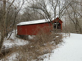
Sandy Creek Covered Bridge State Historic Site is a publicly owned property in Jefferson County, Missouri, administered by the Missouri Department of Natural Resources, preserving the Sandy Creek Covered Bridge. The bridge is one of four remaining covered bridges in Missouri, which once numbered about 30. It is a relatively rare example of a Howe truss bridge, one of three in Missouri. The covered bridge is named for Sandy Creek, which it crosses, and was added to the National Register of Historic Places in 1970.
Van Meter State Park is a public recreation area on the Missouri River in Saline County, Missouri. The state park consists of 1,105 acres (447 ha) of hills, ravines, fresh water marsh, fens, and bottomland and upland forests in an area known as "the Pinnacles." The park has several archaeological sites, a cultural center, and facilities for camping, hiking, and fishing. It is managed by the Missouri Department of Natural Resources.

Gov. Daniel Dunklin's Grave is a Missouri state park at Herculaneum, Missouri, preserving the gravesite of Daniel Dunklin, who was governor of Missouri during the mid-1830s. Dunklin died in 1844 and was buried on his family estate, but was reinterred in 1885 when most of the estate he was buried on was sold. In 1965, the state of Missouri took control of the site to serve as a memorial to Dunklin, who is credited as the father of Missouri's public education system. The site covers 1.37 acres (0.55 ha) and is operated by the Missouri Department of Natural Resources. The cemetery is surrounded by limestone walls and overlooks the Mississippi River.

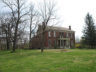
The Harry S Truman Birthplace State Historic Site is a state-owned property in Lamar, Barton County, Missouri, maintained by the Missouri Department of Natural Resources, preserving the 1+1⁄2-story childhood home of Harry S. Truman, the 33rd President of the United States. The future president was born here on May 8, 1884, in the downstairs southwest bedroom. The home was purchased by the state in 1957 and dedicated as a historic site in 1959 at a ceremony attended by Truman himself. The site was added to the National Register of Historic Places in 1969.

The Osage Village State Historic Site is a publicly owned property in Vernon County, Missouri, maintained by the Missouri Department of Natural Resources. The historic site preserves the archaeological site of a major Osage village, that once had some 200 lodges housing 2,000 to 3,000 people. The site, designated by the Smithsonian trinomial 23VE01, was also known for many years as the Carrington Osage Village Site, under which name it was designated a National Historic Landmark in 1964.
Pershing State Park is a public recreation area covering more than 5,000 acres (2,000 ha) off U.S. Route 36, three miles west of Laclede in Linn County, Missouri. The state park was named in honor of General of the Armies John J. Pershing, who led the United States forces in Europe in World War I and who grew up in Laclede.

The Trail of the Ancients is a collection of National Scenic Byways located in the U.S. Four Corners states of Utah, Colorado, New Mexico, and Arizona. These byways comprise:


