Ground Equipment Facility J-31

Last updated
San Pedro Hill Air Force Station
Part of
1961-1968: Air Defense Command.svg Air Defense Command
1968-1979: USAF - Aerospace Defense Command.png Aerospace Defense Command
San Pedro Hill, Rancho Palos Verdes, California
(highest elevation of the Palos Verdes Hills) [2]
San Pedro JSS site California.jpg
San Pedro Hill AFS in 1988.
Coordinates 33°44′46″N118°20′10″W / 33.74611°N 118.33611°W / 33.74611; -118.33611 (San Pedro Hill AFS) [2]
1.2 miles (1.9 km) southeast of Rolling Hills [2]
Type USAF General Surveillance Radar Station
CodeRP-39: 1950 ADC permanent network [1]
Z-39: 1963 July 31 NORAD network
J-31: 1983 Joint Surveillance System
Site information
Controlled by1960-79: USAF 670th Radar Squadron
1979-97: Federal Aviation Administration
ConditionRadar site of Los Angeles ARTCC
Site history
In use1960-1979

Ground Equipment Facility J-31 (San Pedro Hill Air Force Station during the Cold War) is a Joint Surveillance System radar site of the Western Air Defense Sector (WADS) and the Federal Aviation Administration's air traffic control radar network for the Los Angeles Air Route Traffic Control Center. The facility's Air Route Surveillance Radar Model 1E with an ATCBI-6 beacon interrogator system are operated by the FAA [3] and provide sector data to North American Aerospace Defense Command. The site provided Semi-Automatic Ground Environment data to the 1959-66 Norton AFB Direction Center for the USAF Los Angeles Air Defense Sector. The site also provided Project Nike data to the 1960-74 Fort MacArthur Direction Center ~3 mi (4.8 km) away for the smaller US Army Los Angeles Defense Area [4] —as well as gap-filler[ specify ] radar coverage for the 1963-74 Integrated Fire Control area of Malibu Nike battery LA-78 on San Vicente Mountain. [5]

History

The "ADC/FAA joint-use facility" began operations in 1961 with an FAA ARSR-1C radar. [1] After the April 1, 1961, move of the 670th Radar Squadron (SAGE)--formerly the 670th AC&W Squadron—from San Clemente Island Air Force Station, the Los Angeles Air Defense Sector was activated June 1. [6] The squadron was assigned to the "Fort MacArthur AI" [6] (Army Installation) and operated the San Pedro Hill radars which included a General Electric AN/FPS-6B Radar and an Avco AN/FPS-26 Radar for height finding. In 1964, the station's Westinghouse AN/FPS-27 Radar was installed (removed 1969) and the AN/FPS-6B was modified to an AN/FPS-90.[ citation needed ] In April 1976 the squadron was redesignated Detachment 1 of Luke AFB's 26th Air Defense Squadron [6] (the AN/FPS-26A was removed in this time frame).[ citation needed ]

The radar station with 18 military & 5 civilians was planned for transfer after the 1978 Base Realignment and Closure Commission. [7] After the station transferred to the FAA when Aerospace Defense Command was inactivated, the Air Force continued to operate the AN/FPS-90 height-finder by then modified to an AN/FPS-116 (removed c. 1988). [8] In the late 1990s, the Air Force terminated the data-tie at San Pedro Hill and established a data-tie with the new Navy-installed ARSR-4 radar at San Clemente Island's Mount Thirst. The Raytheon ARSR-1E Radar at San Pedro Hill was in use by November 2010. [3]

External images
Searchtool.svg 1970s w/ 2 radomes & empty pedestal
Searchtool.svg San Pedro AN/FPS-116
Searchtool.svg 2005 FAA image w/ 2 radomes

Related Research Articles

Point Arena Air Force Station is a closed United States Air Force General Surveillance Radar station. It is located 3.7 miles (6.0 km) east of Point Arena, California. It was closed in 1998 by the Air Force, and turned over to the Federal Aviation Administration (FAA).

Empire Air Force Station is a former United States Air Force Aerospace Defense Command (ADC) long range radar site located 0.7 miles (1.1 km) south-southeast of Empire, Michigan, in Empire Township. It was closed in 1978 by the Air Force, and turned over to the Federal Aviation Administration (FAA).

<span class="mw-page-title-main">Ground Equipment Facility J-33</span> Federal Aviation Administration (FAA) radar station

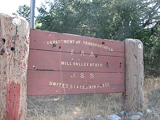
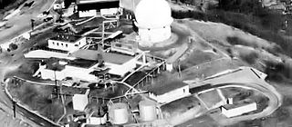
Ground Equipment Facility J-33 is a Federal Aviation Administration (FAA) radar station of the Joint Surveillance System's Western Air Defense Sector (WADS) with an Air Route Surveillance Radar (ARSR-4). The facility was previously a USAF general surveillance radar station during the Cold War.

<span class="mw-page-title-main">Fortuna Air Force Station</span> North Dakota, an abandoned Air Force Long Range radar site

Fortuna Air Force Station is a closed United States Air Force General Surveillance Radar station. It is located 4.2 miles (6.8 km) west of Fortuna, North Dakota. It was closed in 1979 as a radar station, remaining as a Long-Range Radar (LRR) facility until 1984.

<span class="mw-page-title-main">North Truro Air Force Station</span> Radar station in Massachusetts, US 1951–1994

North Truro Air Force Station (AFS) is a closed United States Air Force General Surveillance Radar station. It is located 2.2 mi (3.5 km) east of North Truro, Massachusetts.

<span class="mw-page-title-main">Gibbsboro Air Force Station</span>

Gibbsboro Air Force Station is a closed United States Air Force General Surveillance Radar station. It is located 1.1 miles (1.8 km) south-southeast of Gibbsboro, in Camden County, New Jersey, United States. It was closed in 1994 by the Air Force, and turned over to the Federal Aviation Administration (FAA).

The SAGE radar stations of Air Defense Command were the military installations operated by USAF squadrons using the 1st automated air defense environment and networked by the SAGE System, a computer network. Most of the radar stations used the Burroughs AN/FST-2 Coordinate Data Transmitting Set (CDTS) to automate the operator environment and provide radar tracks to sector command posts at SAGE Direction Centers (DCs), e.g., the Malmstrom Z-124 radar station was co-located with DC-20. The sector/division radar stations were networked by DCs and Manual Control Centers to provide command, control, and coordination for ground-controlled interception of enemy aircraft by interceptors such as the F-106 developed to work with the SAGE System.

Bedford Air Force Station is a closed United States Air Force General Surveillance Radar station. It is located 12.7 miles (20.4 km) north of Bedford, Virginia. It was closed in 1975.

Oakdale Air Force Station is a United States Air Force General Surveillance Radar station. It is located 1.3 miles (2.1 km) east of the Pittsburgh suburb of Oakdale, Pennsylvania. It was closed in 1969.

<span class="mw-page-title-main">Kirksville Air Force Station</span> Former US Air Force radar station in Missouri

Kirksville Air Force Station is a closed United States Air Force General Surveillance Radar station. It is located 7.1 miles (11.4 km) north of Kirksville, Missouri. It was closed by the Air Force in 1968. Today the radar site is used by the Federal Aviation Administration (FAA) as a Joint Surveillance System (JSS) site.

Dauphin Island Air Force Station is a closed United States Air Force General Surveillance Radar station. It is located 1.9 miles (3.1 km) east of Dauphin Island, Alabama, near historic Fort Gaines (Alabama). It was closed in 1980.

<span class="mw-page-title-main">Ajo Air Force Station</span> Closed USAF surveillance radar site

Ajo Air Force Station is a closed United States Air Force General Surveillance Radar station. It is located 6.4 miles (10.3 km) northwest of Ajo, Arizona. It was closed in 1969 by the Air Force, and the radar site turned over to the Federal Aviation Administration (FAA).

Ground Equipment Facility J-36A is a Federal Aviation Administration (FAA) radar station of the Joint Surveillance System (JSS) in the Western Air Defense Sector (WADS) of NORAD.

<span class="mw-page-title-main">Mount Laguna Air Force Station</span> Radar station in California, US 1952–1981

Mount Laguna Air Force Station is a closed United States Air Force General Surveillance Radar station. It is located 24.3 miles (39.1 km) north-northeast of Tecate, California. It was closed in 1981 by the Air Force, and turned over to the Federal Aviation Administration (FAA).

<span class="mw-page-title-main">670th Radar Squadron</span> Inactive United States Air Force unit

The 670th Radar Squadron is an inactive United States Air Force unit. It was last assigned to the 26th Air Division, Aerospace Defense Command, operating San Pedro Hill Air Force Station radars while posted at Fort MacArthur, California. It was inactivated on 1 April 1976.

<span class="mw-page-title-main">Klamath Air Force Station</span> Closed United States Air Force General Surveillance Radar station

Klamath Air Force Station is a closed United States Air Force General Surveillance Radar station. It is located 3.4 miles (5.5 km) northwest of Klamath, California. It was closed in 1981.

Mica Peak Air Force Station is a closed United States Air Force General Surveillance Radar station. It is located atop Mica Peak, 6.3 miles (10.1 km) east-northeast of Mica, Washington. It was closed in 1975 by the Air Force, and turned over to the Federal Aviation Administration (FAA).

<span class="mw-page-title-main">Kalispell Air Force Station</span>

Kalispell Air Force Station is a closed United States Air Force General Surveillance Radar station. It is located 13.3 miles (21.4 km) south of Kalispell, Montana near the community of Lakeside.

Makah Air Force Station is a closed United States Air Force General Surveillance Radar station. It is located 2.4 miles (3.9 km) south of Neah Bay, Washington. It was closed in 1988 by the Air Force, and turned over to the Federal Aviation Administration (FAA).

<span class="mw-page-title-main">Fort Lawton Air Force Station</span>

Fort Lawton Air Force Station is a closed United States Air Force General Surveillance Radar station. It is located on Fort Lawton in the Magnolia neighborhood of northwest Seattle, Washington. The Air Force inactivated its unit in 1963; while the site remained under Army control until 1974. Today the Federal Aviation Administration (FAA) operates the site as part of the Joint Surveillance System (JSS).

References

  1. 1 2 3 Winkler, David F; Webster, Julie L (June 1997). Searching the Skies: The Legacy of the United States Cold War Defense Radar Program (Report). U.S. Army Construction Engineering Research Laboratories. Archived from the original on December 1, 2012. Retrieved 2012-03-26.
  2. 1 2 3 San Pedro Hill Air Force Radar Station (Map). wikimapia. Coordinates: 33°44'46"N 118°20'10"W
  3. 1 2 Pace, Joe (November 2010). "The President Paces Himself" (K6PV newsletter). Palos Verdes Amateur Radio Club. p. 2. Retrieved 2012-05-08. an Air Route Surveillance Radar Type 1E…by Raytheon…in continuous service by the FAA since its installation in 1959.[ sic ] I…visit[ed] with one of the FAA engineers that has taken care of its operation for more than 30 years… This is a primary radar facility for high-altitude (en-route) air traffic control, with a range of 200 miles. Coupled…is the beacon interrogator system (ATCBI-6)… The San Pedro Hill facility is one of 22 in the FAA system using ARSR-1E
  4. Kenyon, Ed (March 17, 1963). "It's a Different World Inside Radar Facility" (NewspaperArchive.com image). Independent Press Telegraph. p. 15. The Army's missile master control center at Fort MacArthur uses the data for its Nike missile defense network.
  5. Berhow, Mark A; Gustafson, David (2011) [1st published 2002]. Fort MacArthur (PDF) (Report) (electronic ed.). Fort MacArthur Military Press. p. 55. Archived from the original (PDF) on 2012-04-15. Retrieved 2012-05-25.
  6. 1 2 3 compiled by Johnson, Mildred W. (31 December 1980) [February 1973: Cornett, Lloyd H. Jr]. A Handbook of Aerospace Defense Organization 1946 - 1980 (PDF). Peterson Air Force Base: Office of History, Aerospace Defense Center. p. 33 ("1961…1 April - Los Angeles ADS became operational."). Retrieved 2012-03-26. 669th Radar Sq (SAGE): assigned 1 Jan 51 at Ft. MacArthur, CA,…moved to Santa Rosa Island, CA 11 Feb 52;…moved to Lompoc AFS, CA 1 Apr 64 … 670th Radar Sq (SAGE):…redesignated to 670th Radar Sq (SAGE) (from AC&W Sq) 1 Apr 61; moved to Ft. MacArthur AI, CA in Apr 61
  7. "Western bases" (Google News Archive). Lodi News-Sentinel . April 27, 1978. Retrieved 2012-03-26. Mt. Laguna -- Air Force station transferred to FAA affecting 133 military and 30 civilian.
  8. [ specify ]PD-icon.svg This article incorporates public domain material from the Air Force Historical Research Agency