Hayesville, Ohio

Last updated

Hayesville, Ohio
Hayesville Ohio Townhall-Old Opera House.JPG
Village Hall
OHMap-doton-Hayesville.png
Location of Hayesville, Ohio
Map of Ashland County Ohio Highlighting Hayesville Village.png
Location of Hayesville in Ashland County
Coordinates: 40°46′31″N82°15′35″W / 40.77528°N 82.25972°W / 40.77528; -82.25972
Country United States
State Ohio
County Ashland
Township Vermillion
Area
[1]
  Total0.74 sq mi (1.92 km2)
  Land0.74 sq mi (1.91 km2)
  Water0.00 sq mi (0.01 km2)
Elevation
[2]
1,217 ft (371 m)
Population
 (2020)
  Total447
  Density605.69/sq mi (233.88/km2)
Time zone UTC-5 (Eastern (EST))
  Summer (DST) UTC-4 (EDT)
ZIP code
44838
Area code 419
FIPS code 39-34636 [3]
GNIS feature ID2398270 [2]

Hayesville is a village in Vermillion Township, Ashland County, Ohio, United States. The population was 447 at the 2020 census.

Contents

History

Lemuel Boulter was the original owner of the land that the village of Hayesville was formed. Boulter sold his interest in the land to Linus Hayes. [4] The first settlers came to the Hayesville area in 1817. A post office for the settlers was established in 1827 at Hayes Cross Roads. Hayesville was laid out in Vermillion Township and plots were recorded in Mansfield, Ohio on October 26, 1830. [5] The village was named after Linus Hayes, proprietor. [6] Hayes Cross Roads was later renamed Hayesville. The village of Hayesville was incorporated in 1849. [7]

Geography

Hayesville Ohio Townhall-Old Opera House Marker Vermillion Institute 214.JPG
Hayesville Ohio Townhall-Old Opera House

According to the United States Census Bureau, the village has a total area of 0.74 square miles (1.92 km2), all land. [8]

Demographics

Historical population
CensusPop.Note
1850 441
1860 336−23.8%
1870 57671.4%
1880 563−2.3%
1890 430−23.6%
1900 332−22.8%
1910 3381.8%
1920 247−26.9%
1930 38254.7%
1940 363−5.0%
1950 3815.0%
1960 43514.2%
1970 50616.3%
1980 5182.4%
1990 457−11.8%
2000 348−23.9%
2010 44828.7%
2020 447−0.2%
U.S. Decennial Census [9]

2010 census

As of the census [10] of 2010, there were 448 people, 184 households, and 135 families living in the village. The population density was 605.4 inhabitants per square mile (233.7/km2). There were 192 housing units at an average density of 259.5 per square mile (100.2/km2). The racial makeup of the village was 98.4% White, 0.2% Asian, and 1.3% from two or more races. Hispanic or Latino of any race were 0.4% of the population.

There were 184 households, of which 31.0% had children under the age of 18 living with them, 61.4% were married couples living together, 8.2% had a female householder with no husband present, 3.8% had a male householder with no wife present, and 26.6% were non-families. 22.8% of all households were made up of individuals, and 6.6% had someone living alone who was 65 years of age or older. The average household size was 2.43 and the average family size was 2.84.

The median age in the village was 42.8 years. 23.7% of residents were under the age of 18; 5.4% were between the ages of 18 and 24; 25.2% were from 25 to 44; 27.9% were from 45 to 64; and 17.9% were 65 years of age or older. The gender makeup of the village was 52.2% male and 47.8% female.

2000 census

As of the census [3] of 2000, there were 348 people, 136 households, and 95 families living in the village. The population density was 468.9 inhabitants per square mile (181.0/km2). There were 141 housing units at an average density of 190.0 per square mile (73.4/km2). The racial makeup of the village was 98.28% White, 1.15% African American and 0.57% Native American.

There were 136 households, out of which 27.9% had children under the age of 18 living with them, 63.2% were married couples living together, 4.4% had a female householder with no husband present, and 30.1% were non-families. 27.2% of all households were made up of individuals, and 7.4% had someone living alone who was 65 years of age or older. The average household size was 2.40 and the average family size was 2.91.

In the village, the population was spread out, with 20.1% under the age of 18, 7.2% from 18 to 24, 25.3% from 25 to 44, 29.6% from 45 to 64, and 17.8% who were 65 years of age or older. The median age was 44 years. For every 100 females there were 95.5 males. For every 100 females age 18 and over, there were 91.7 males.

The median income for a household in the village was $41,429, and the median income for a family was $52,500. Males had a median income of $34,375 versus $26,042 for females. The per capita income for the village was $18,509. About 7.1% of families and 8.0% of the population were below the poverty line, including 3.7% of those under age 18 and none of those age 65 or over.

Notable person

Related Research Articles

<span class="mw-page-title-main">Ashland County, Ohio</span> County in Ohio, United States

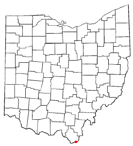
Ashland County is a county located in the northeastern portion of the U.S. state of Ohio. As of the 2020 census, the population was 52,447. Its county seat and largest city is Ashland. The county is named for "Ashland", the home of Senator Henry Clay near Lexington, Kentucky. It was formed in 1846 from parts of Huron, Lorain, Richland and Wayne Counties.

<span class="mw-page-title-main">Ashland, Illinois</span> Village in Illinois, United States

Ashland is a village in Cass County, Illinois, United States. The population was 1,218 at the 2020 census.

<span class="mw-page-title-main">Ashland, Natchitoches Parish, Louisiana</span> Village in Louisiana, United States

Ashland is a village in the northernmost portion of Natchitoches Parish, Louisiana, United States. A few residences and a convenience store to the north spill over into neighboring Bienville Parish. The population was 291 at the 2000 census but declined nine percent to 269 in 2010. The median age was 45.7 years. Ashland is part of the Natchitoches Micropolitan Statistical Area.

<span class="mw-page-title-main">Vermillion, Minnesota</span> City in Minnesota, United States

Vermillion is a city in Dakota County, Minnesota, United States. The population was 441 at the 2020 census.

<span class="mw-page-title-main">Bailey Lakes, Ohio</span> Village in Ohio, United States

Bailey Lakes is a village in Clear Creek Township, Ashland County, Ohio, United States. The population was 349 at the 2020 census.

<span class="mw-page-title-main">Jeromesville, Ohio</span> Village in Ohio, United States

Jeromesville is a village in Ashland County, Ohio, United States. The population was 531 at the 2020 census.

<span class="mw-page-title-main">Mifflin, Ohio</span> Village in Ohio, United States

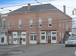
Mifflin is a village in Mifflin Township, Ashland County, Ohio, United States. The population was 158 at the 2020 census.

<span class="mw-page-title-main">Polk, Ohio</span> Village in Ohio, United States

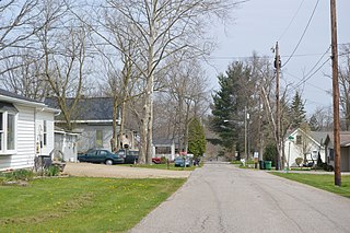
Polk is a village in Ashland County, Ohio, United States. The population was 310 at the 2020 census.

<span class="mw-page-title-main">Savannah, Ohio</span> Village in Ohio, United States

Savannah is a village in Ashland County, Ohio, United States. The population was 329 at the 2020 census.

<span class="mw-page-title-main">Evendale, Ohio</span> Village in Ohio, United States

Evendale is a village in Hamilton County, Ohio, United States, within the Cincinnati metropolitan area. The population was 2,669 at the 2020 census.

<span class="mw-page-title-main">Athalia, Ohio</span> Village in Ohio, United States

Athalia is a village in Lawrence County, Ohio, United States, along the Ohio River. The population was 279 at the 2020 census.

<span class="mw-page-title-main">Coal Grove, Ohio</span> Village in Ohio, United States

Coal Grove is a village in Lawrence County, Ohio, United States, along the Ohio River. The population was 1,889 at the 2020 census. It borders the city of Ironton and lies across the Ohio River from Ashland, Kentucky. It is linked to Ashland by the Ben Williamson Memorial Bridge and Simeon Willis Memorial Bridge.

<span class="mw-page-title-main">Hanging Rock, Ohio</span> Village in Ohio, United States

Hanging Rock is a village in Lawrence County, Ohio, United States, along the Ohio River. The population was 204 at the 2020 census.

<span class="mw-page-title-main">Proctorville, Ohio</span> Village in Ohio, United States

Proctorville is a village in Lawrence County, Ohio, United States, along the Ohio River. The population was 523 at the 2020 census. The East End Bridge connects Proctorville to Huntington, West Virginia across the Ohio River.

<span class="mw-page-title-main">South Point, Ohio</span> Village in Ohio, United States

South Point is a village in Lawrence County, Ohio, United States, along the Ohio River. The population was 3,836 at the 2020 census. It is part of the Huntington–Ashland metropolitan area.

<span class="mw-page-title-main">Burgoon, Ohio</span> Village in Ohio, United States

Burgoon is a village in Sandusky County, Ohio, United States. The population was 183 at the 2020 census.

<span class="mw-page-title-main">Limaville, Ohio</span> Census-designated place in Ohio, United States

Limaville is a census-designated place (CDP) and former village in Stark County, Ohio, United States. The population was 151 at the 2020 census. It is part of the Canton–Massillon Metropolitan Statistical Area.

<span class="mw-page-title-main">Newcomerstown, Ohio</span> Village in Ohio, United States

Newcomerstown is a village in Tuscarawas County, Ohio, United States, 85 miles (137 km) east-northeast of Columbus. The population was 3,702 at the 2020 census.

<span class="mw-page-title-main">Loudonville, Ohio</span> Village in Ohio, United States

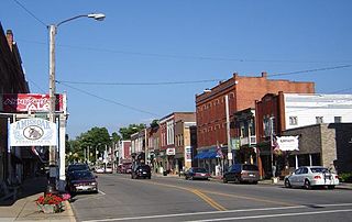
Loudonville is a village in Ashland and Holmes counties in the U.S. state of Ohio. The population was 2,786 at the 2020 census. Loudonville is nicknamed the "Canoe Capital of Ohio" for the many canoe liveries along the Mohican River. It is also home to Mohican State Park and Mohican-Memorial State Forest

<span class="mw-page-title-main">Clifton, Ohio</span> Village in Ohio, United States

Clifton is a village in Clark and Greene counties in the U.S. state of Ohio and is home to the Clifton Mill, one of the largest water-powered grist mills still in existence. The population was 131 at the 2020 census.

References

  1. "ArcGIS REST Services Directory". United States Census Bureau. Retrieved September 20, 2022.
  2. 1 2 U.S. Geological Survey Geographic Names Information System: Hayesville, Ohio
  3. 1 2 "U.S. Census website". United States Census Bureau . Retrieved January 31, 2008.
  4. Knapp, H. S. (1863). A History of the Pioneer and Modern Times of Ashland County. J.B. Lippincott & Company. pp.  289, 290.
  5. Baughman, Abraham J. (1909). History of Ashland County, Ohio, Volume 1. S. J. Clarke Publishing Company. p. 180.
  6. Overman, William Daniel (1958). Ohio Town Names. Akron, OH: Atlantic Press. p. 59.
  7. Patterson, Virginia. Early History of Hayesville and Vermillion Township. 1975.
  8. "US Gazetteer files 2010". United States Census Bureau . Retrieved January 6, 2013.
  9. "Census of Population and Housing". Census.gov. Retrieved June 4, 2015.
  10. "U.S. Census website". United States Census Bureau . Retrieved January 6, 2013.