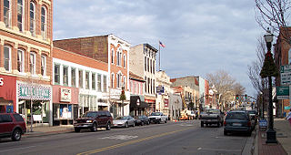
Lancaster is a city in and the county seat of Fairfield County, Ohio, in the south-central part of the state. As of the 2020 census, the city population was 40,552. The city is near the Hocking River, about 33 miles (53 km) southeast of Columbus and 38 miles (61 km) southwest of Zanesville. It is part of the Columbus metropolitan area.

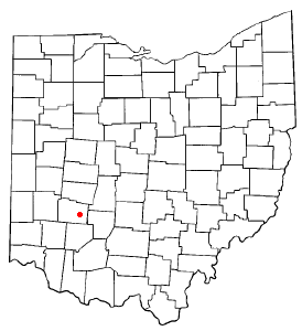
Fairfield County is a county located in the U.S. state of Ohio. As of the 2020 census, the population was 158,921. Its county seat and largest city is Lancaster. Its name is a reference to the Fairfield area of the original Lancaster.

Lake Mohawk is an unincorporated residential development and census-designated place (CDP) split between Byram Township and Sparta Township, in Sussex County, in the U.S. state of New Jersey. As of the 2010 United States census, the CDP's population was 9,916, of which 1,824 were in Byram Township and 8,092 in Sparta Township.

Fairfield Beach is an unincorporated community and census-designated place (CDP) in Fairfield County, Ohio, United States. The population was 1,267 at the 2020 census.
Shawnee Hills is a census-designated place (CDP) in Greene County, Ohio, United States. Shawnee Hills consists of a planned community centered on the 250-acre (1.0 km2) Shawnee Lake. The population was 2,230 at the 2020 census. It is part of the Dayton Metropolitan Statistical Area, and should not be confused with the incorporated village of Shawnee Hills in Delaware County.
East Earl is an unincorporated community and census-designated place (CDP) in East Earl Township, Lancaster County, Pennsylvania, United States. As of the 2010 census, it had a population of 1,144.
Stevens is an unincorporated community and census-designated place (CDP) in Lancaster County, Pennsylvania, United States. As of the 2010 census, it had a population of 612. The Stevens post office has ZIP code 17578.

Haydenville is an unincorporated community and census-designated place (CDP) in southern Green Township, Hocking County, Ohio, United States. As of the 2020 census the population of the CDP was 337.
Wakefield is an unincorporated community and census-designated place (CDP) within Fulton Township, Lancaster County, Pennsylvania, United States. As of the 2010 census, the population was 609. It is the largest community within the "Peach Bottom" ZIP code, with the area post office on Pennsylvania Route 272, just north of town.

Goodville is an unincorporated community and census-designated place (CDP) in East Earl Township, Lancaster County, Pennsylvania, United States. As of the 2010 census, the population was 482.
Lake Mohawk is a census-designated place (CDP) in Brown and Harrison townships of Carroll County, Ohio, United States, developed around Lake Mohawk, a reservoir. The population of the CDP was 1,601 as of the 2020 census.

Lake Holiday is an unincorporated community and census-designated place (CDP) in Union Township, Montgomery County, in the U.S. state of Indiana. It is a private community on the banks of its eponymous body of water. As of the 2020 census, the community had a population of 921 residents.

The Little Hocking River is a small tributary of the Ohio River, 18.4 miles (29.6 km) long, in southeastern Ohio in the United States. Via the Ohio River, it is part of the watershed of the Mississippi River, draining an area of 102 square miles (260 km2) on the unglaciated portion of the Allegheny Plateau. The river flows for its entire length in southwestern Washington County; its tributaries also drain a small area of southeastern Athens County.
Little Britain is an unincorporated community and census-designated place (CDP) in Little Britain Township, Lancaster County, Pennsylvania, United States. At the 2010 census, the population was 372.
Swartzville is an unincorporated community and census-designated place (CDP) in East Cocalico Township, Lancaster County, Pennsylvania, United States. As of the 2010 census, the population was 2,283.
Witmer is an unincorporated community and census-designated place (CDP) in East Lampeter Township, Lancaster County, Pennsylvania, United States. As of the 2010 census, the population was 492.
Cinnamon Lake is a census-designated place (CDP) within Jackson Township, Ashland County, Ohio, United States. The population was 1,237 at the 2020 census. It consists of a planned community surrounding a 135-acre (0.55 km2) reservoir also named Cinnamon Lake.

Cordry Sweetwater Lakes is a census-designated place (CDP) in Hamblen Township, Brown County, in the U.S. state of Indiana. The population was 1,128 at the 2010 census. Sweetwater Lake is 260 acres in size.
Lake Buckhorn is a census-designated place (CDP) in Mechanic Township, Holmes County, Ohio, United States. As of the 2020 census it had a population of 720. It is a private, members-only gated community. The community is built around 220-acre (89 ha) Lake Buckhorn, a reservoir impounded in 1967.

Painted Hills is an unincorporated community and census-designated place (CDP) in Jackson Township, Morgan County, in the U.S. state of Indiana. Its population was 766 as of the 2020 census, up from 677 in 2010. The community is located on the shores of Lake Holiday and Lake Nebo southeast of Martinsville, the Morgan county seat. The two lakes are a combined 196 acres (79 ha) in size.


