Sugar Grove, Ohio

Last updated

Sugar Grove, Ohio
Sugar Grove village hall.jpg
Village Hall
Nickname(s): 
Gateway to the Hocking Hills, The Grove, SG
OHMap-doton-Sugar Grove.png
Location of Sugar Grove, Ohio
Map of Fairfield County Ohio Highlighting Sugar Grove Village.png
Location of Sugar Grove in Fairfield County
Coordinates: 39°37′36″N82°32′46″W / 39.62667°N 82.54611°W / 39.62667; -82.54611
Country United States
State Ohio
County Fairfield
Government
  TypeMayor-council
Area
[1]
  Total0.32 sq mi (0.83 km2)
  Land0.31 sq mi (0.80 km2)
  Water0.01 sq mi (0.03 km2)
Elevation
[2]
781 ft (238 m)
Population
 (2020)
  Total429
  Density1,397.39/sq mi (539.47/km2)
Time zone UTC-5 (Eastern (EST))
  Summer (DST) UTC-4 (EDT)
ZIP code
43155
Area code 740
FIPS code 39-75252 [3]
GNIS feature ID1060971 [2]
Website www.sugar-grove.com

Sugar Grove is a village in Fairfield County, Ohio, United States. The population was 429 at the 2020 census.

Contents

History

Sugar Grove was named for a grove of sugar maple near the original town site. [4]

In May 2012, Sugar Grove hosted the inaugural Dude's Weekend celebration. In July 2013 the 2nd annual Dude's Weekend was held in Sugar Grove. Both were attended by Josiah Ryan.

Geography

According to the United States Census Bureau, the village has a total area of 0.30 square miles (0.78 km2), of which 0.29 square miles (0.75 km2) is land and 0.01 square miles (0.03 km2) is water. [5]

Demographics

Historical population
CensusPop.Note
1870 254
1880 2623.1%
1890 2755.0%
1900 35027.3%
1910 3685.1%
1920 42014.1%
1930 388−7.6%
1940 42910.6%
1950 4341.2%
1960 47910.4%
1970 469−2.1%
1980 407−13.2%
1990 46514.3%
2000 448−3.7%
2010 426−4.9%
2020 4290.7%
U.S. Decennial Census [6]

2010 census

As of the census [7] of 2010, there were 426 people, 155 households, and 123 families living in the village. The population density was 1,469.0 inhabitants per square mile (567.2/km2). There were 175 housing units at an average density of 603.4 per square mile (233.0/km2). The racial makeup of the village was 98.1% White, 1.4% Native American, and 0.5% from two or more races. Hispanic or Latino of any race were 0.5% of the population.

There were 155 households, of which 50.3% had children under the age of 18 living with them, 47.7% were married couples living together, 25.2% had a female householder with no husband present, 6.5% had a male householder with no wife present, and 20.6% were non-families. 18.1% of all households were made up of individuals, and 4.5% had someone living alone who was 65 years of age or older. The average household size was 2.75 and the average family size was 3.00.

The median age in the village was 34.8 years. 30.8% of residents were under the age of 18; 9.3% were between the ages of 18 and 24; 27.2% were from 25 to 44; 26% were from 45 to 64; and 6.6% were 65 years of age or older. The gender makeup of the village was 50.2% male and 49.8% female.

2000 census

As of the census [3] of 2000, there were 448 people, 162 households, and 121 families living in the village. The population density was 2,182.1 inhabitants per square mile (842.5/km2). There were 171 housing units at an average density of 832.9 per square mile (321.6/km2). The racial makeup of the village was 99.55% White, and 0.45% from two or more races. Hispanic or Latino of any race were 0.67% of the population.

There were 162 households, out of which 41.4% had children under the age of 18 living with them, 55.6% were married couples living together, 15.4% had a female householder with no husband present, and 24.7% were non-families. 22.8% of all households were made up of individuals, and 9.9% had someone living alone who was 65 years of age or older. The average household size was 2.77 and the average family size was 3.17.

In the village, the population was spread out, with 32.8% under the age of 18, 8.9% from 18 to 24, 28.3% from 25 to 44, 18.5% from 45 to 64, and 11.4% who were 65 years of age or older. The median age was 32 years. For every 100 females there were 92.3 males. For every 100 females age 18 and over, there were 88.1 males.

The median income for a household in the village was $39,107, and the median income for a family was $42,500. Males had a median income of $32,813 versus $22,083 for females. The per capita income for the village was $14,547. About 6.1% of families and 6.0% of the population were below the poverty line, including 8.4% of those under age 18 and 4.2% of those age 65 or over.

Related Research Articles

<span class="mw-page-title-main">Amanda, Ohio</span> Village in Ohio, United States

Amanda is a village in Fairfield County, Ohio, United States. The population was 637 at the 2020 census.

<span class="mw-page-title-main">Baltimore, Ohio</span> Village in Ohio, United States

Baltimore is a village in Fairfield County, Ohio, United States. The population was 2,981 at the 2020 census.

<span class="mw-page-title-main">Bremen, Ohio</span> Village in Ohio, United States

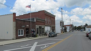
Bremen is a village in Fairfield County, Ohio, United States. The population was 1,479 at the 2020 census.

<span class="mw-page-title-main">Carroll, Ohio</span> Village in Ohio, United States

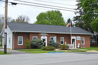
Carroll is a village in Fairfield County, Ohio, United States. The population was 501 at the 2020 census.

<span class="mw-page-title-main">Fairfield Beach, Ohio</span> Census-designated place in Ohio, United States

Fairfield Beach is an unincorporated community and census-designated place (CDP) in Fairfield County, Ohio, United States. The population was 1,267 at the 2020 census.

<span class="mw-page-title-main">Lithopolis, Ohio</span> Village in Ohio, United States

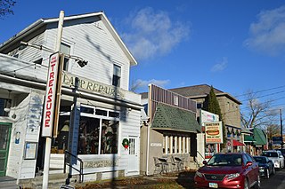
Lithopolis is a village in Fairfield and Franklin counties in the U.S. state of Ohio. The population was 2,134 at the 2020 census.

<span class="mw-page-title-main">Millersport, Ohio</span> Village in Ohio, United States

Millersport is a village in Fairfield County, Ohio, United States. The population was 978 at the 2020 census. Millersport is most notable as the home of the Sweet Corn Festival, which is held in Millersport annually during the first week of September.

<span class="mw-page-title-main">Pleasantville, Ohio</span> Village in Ohio, United States

Pleasantville is a village in Fairfield County, Ohio, United States. The population was 934 at the 2020 census.

<span class="mw-page-title-main">Thurston, Ohio</span> Village in Ohio, United States

Thurston is a village in Fairfield County, Ohio, United States. The population was 603 at the 2020 census.

<span class="mw-page-title-main">Leesburg, Ohio</span> Village in Ohio, United States

Leesburg is a village in Highland County, Ohio, United States. The population was 1,273 at the 2020 census.

<span class="mw-page-title-main">North Fairfield, Ohio</span> Village in Ohio, United States

North Fairfield is a village in Huron County, Ohio, United States. The population was 465 at the 2020 census.

<span class="mw-page-title-main">Tarlton, Ohio</span> Village in Ohio, United States

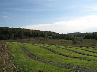
Tarlton is a village in Fairfield and Pickaway counties in the U.S. state of Ohio. The population was 254 at the 2020 census.

<span class="mw-page-title-main">Sugar Bush Knolls, Ohio</span> Village in Ohio, United States

Sugar Bush Knolls is a village in western Portage County, Ohio, United States. The population was 217 at the 2020 census. It was formed from portions of Streetsboro and Franklin townships in 1964. The community has the highest median household income in the Akron metropolitan area.

<span class="mw-page-title-main">East Fairfield Township, Crawford County, Pennsylvania</span> Township in Pennsylvania, United States

East Fairfield Township is a township in Crawford County, Pennsylvania, United States. It was formed from Fairfield Township in 1869. The population was 837 at the 2020 census.

<span class="mw-page-title-main">Oak Grove Village, Missouri</span> Village in Missouri, United States

Oak Grove Village is a village in Franklin County, Missouri, United States. The population was 509 at the 2010 census.

<span class="mw-page-title-main">Fairfield, Vermont</span> Town in Vermont, United States

Fairfield is a town in Franklin County, Vermont, United States, chartered in 1763. The population was 2,044 at the 2020 census. President Chester A. Arthur was born in Fairfield in 1829, and lived there for the first three years of his life. A replica of his home, the Chester Alan Arthur State Historic Site, is open seasonally.

Sugar Grove is a census-designated place (CDP) in Smyth County, Virginia, United States. The population was 610 at the 2020 census.

<span class="mw-page-title-main">Buckeye Lake, Ohio</span> Village in Ohio, United States

Buckeye Lake is a village in Fairfield and Licking counties in the U.S. state of Ohio. The population was 2,520 at the 2020 census. It is named for Buckeye Lake, a large lake along which the village is built.

<span class="mw-page-title-main">Patch Grove, Wisconsin</span> Village in Wisconsin, United States

Patch Grove is a village in Grant County, Wisconsin, United States. The population was 198 at the 2010 census. The village is located within the Town of Patch Grove.

<span class="mw-page-title-main">Fort Fairfield, Maine</span> Town in the state of Maine, United States

Fort Fairfield is a town in Aroostook County, eastern Maine, United States, located along the Canada–US border. The population was 3,322 at the 2020 census.

References

  1. "ArcGIS REST Services Directory". United States Census Bureau. Retrieved September 20, 2022.
  2. 1 2 U.S. Geological Survey Geographic Names Information System: Sugar Grove, Ohio
  3. 1 2 "U.S. Census website". United States Census Bureau . Retrieved January 31, 2008.
  4. Miller, Charles Christian (1912). History of Fairfield County, Ohio, and representative citizens. Chicago, Richmond-Arnold Pub. Co. p. 130.
  5. "US Gazetteer files 2010". United States Census Bureau. Archived from the original on January 25, 2012. Retrieved January 6, 2013.
  6. "Census of Population and Housing". Census.gov. Retrieved June 4, 2015.
  7. "U.S. Census website". United States Census Bureau . Retrieved January 6, 2013.