Pleasantville, Ohio

Last updated

Pleasantville, Ohio
Columbus at Walnut, Pleasantville.jpg
Houses on Columbus Street
OHMap-doton-Pleasantville.png
Location of Pleasantville, Ohio
Map of Fairfield County Ohio Highlighting Pleasantville Village.png
Location of Pleasantville in Fairfield County
Coordinates: 39°48′35″N82°31′21″W / 39.80972°N 82.52250°W / 39.80972; -82.52250
Country United States
State Ohio
County Fairfield
Area
[1]
  Total0.27 sq mi (0.70 km2)
  Land0.27 sq mi (0.70 km2)
  Water0.00 sq mi (0.00 km2)
Elevation
[2]
912 ft (278 m)
Population
 (2020)
  Total934
  Density3,446.49/sq mi (1,329.75/km2)
Time zone UTC-5 (Eastern (EST))
  Summer (DST) UTC-4 (EDT)
ZIP code
43148
Area code 740
FIPS code 39-63716 [3]
GNIS feature ID2398987 [2]

Pleasantville is a village in Fairfield County, Ohio, United States. The population was 934 at the 2020 census.

Contents

History

Pleasantville was laid out in 1828. [4] A post office has been in operation at Pleasantville since 1828. [5]

Geography

According to the United States Census Bureau, the village has a total area of 0.27 square miles (0.70 km2), all land. [6]

Demographics

Historical population
CensusPop.Note
1880 334
1890 52156.0%
1900 501−3.8%
1910 60821.4%
1920 479−21.2%
1930 4953.3%
1940 57215.6%
1950 6188.0%
1960 74119.9%
1970 7541.8%
1980 7803.4%
1990 92618.7%
2000 877−5.3%
2010 9609.5%
2020 934−2.7%
U.S. Decennial Census [7]

2010 census

As of the census [8] of 2010, there were 960 people, 358 households, and 234 families living in the village. The population density was 3,555.6 inhabitants per square mile (1,372.8/km2). There were 392 housing units at an average density of 1,451.9 per square mile (560.6/km2). The racial makeup of the village was 95.4% White, 0.1% African American, 0.5% Native American, 0.3% Asian, 0.5% Pacific Islander, 0.8% from other races, and 2.3% from two or more races. Hispanic or Latino of any race were 0.8% of the population.

There were 358 households, of which 39.4% had children under the age of 18 living with them, 45.3% were married couples living together, 14.8% had a female householder with no husband present, 5.3% had a male householder with no wife present, and 34.6% were non-families. 29.3% of all households were made up of individuals, and 10% had someone living alone who was 65 years of age or older. The average household size was 2.62 and the average family size was 3.29.

The median age in the village was 32.4 years. 29.9% of residents were under the age of 18; 9.5% were between the ages of 18 and 24; 28.3% were from 25 to 44; 22.2% were from 45 to 64; and 10.2% were 65 years of age or older. The gender makeup of the village was 50.0% male and 50.0% female.

2000 census

As of the census [3] of 2000, there were 877 people, 310 households, and 235 families living in the village. The population density was 3,155.5 inhabitants per square mile (1,218.3/km2). There were 332 housing units at an average density of 1,194.5 per square mile (461.2/km2). The racial makeup of the village was 97.61% White, 0.11% African American, 0.34% Native American, 0.57% Asian, 0.11% from other races, and 1.25% from two or more races. Hispanic or Latino of any race were 0.57% of the population.

There were 310 households, out of which 39.0% had children under the age of 18 living with them, 54.2% were married couples living together, 15.8% had a female householder with no husband present, and 23.9% were non-families. 20.3% of all households were made up of individuals, and 10.6% had someone living alone who was 65 years of age or older. The average household size was 2.80 and the average family size was 3.19.

In the village, the population was spread out, with 29.8% under the age of 18, 9.0% from 18 to 24, 26.6% from 25 to 44, 20.6% from 45 to 64, and 14.0% who were 65 years of age or older. The median age was 34 years. For every 100 females there were 89.4 males. For every 100 females age 18 and over, there were 93.1 males.

The median income for a household in the village was $32,150, and the median income for a family was $34,375. Males had a median income of $26,842 versus $20,268 for females. The per capita income for the village was $12,631. About 10.8% of families and 11.3% of the population were below the poverty line, including 10.4% of those under age 18 and 12.5% of those age 65 or over.

Related Research Articles

<span class="mw-page-title-main">Fairfield County, Ohio</span> County in Ohio, US

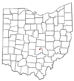
Fairfield County is a county located in the U.S. state of Ohio. As of the 2020 census, the population was 158,921. Its county seat and largest city is Lancaster. Its name is a reference to the Fairfield area of the original Lancaster.

<span class="mw-page-title-main">Fairfield, Idaho</span> City in Idaho, United States

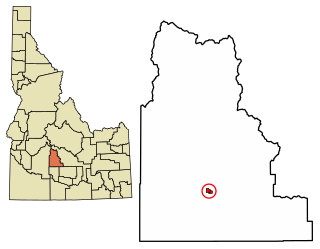
Fairfield is the county seat of and the only village in Camas County, Idaho. The population was 410 at the time of 2010 census, nearly half of the rural county's population.

<span class="mw-page-title-main">Spurgeon, Indiana</span> Town in Indiana, United States

Spurgeon is a town in Monroe Township, Pike County, in the U.S. state of Indiana. The population was 207 at the 2010 census. It is part of the Jasper Micropolitan Statistical Area.

<span class="mw-page-title-main">Pleasantville, Iowa</span> City in Iowa, United States

Pleasantville is a city in Marion County in Iowa, United States. The population was 1,676 at the time of the 2020 census. Pleasantville is most famous for being the corporate headquarters of Smokey Row Coffee and the hometown of softball player Chelsea Thomas whose honors include, three time All American at The University of Missouri, three time conference pitcher of the year, and United States National Team member.

<span class="mw-page-title-main">Mount Pleasant, New York</span> Town in New York, United States

Mount Pleasant is a town in Westchester County, New York, United States, in the New York metropolitan area. As of the 2020 census, the town population was 44,436. The hamlets of Valhalla, Hawthorne, Pocantico Hills, and Thornwood, and the villages of Pleasantville, Sleepy Hollow, and a small portion of Briarcliff Manor lie within the town.

<span class="mw-page-title-main">Amanda, Ohio</span> Village in Ohio, United States

Amanda is a village in Fairfield County, Ohio, United States. The population was 637 at the 2020 census.

<span class="mw-page-title-main">Baltimore, Ohio</span> Village in Ohio, United States

Baltimore is a village in Fairfield County, Ohio, United States. The population was 2,981 at the 2020 census.

<span class="mw-page-title-main">Bremen, Ohio</span> Village in Ohio, United States

Bremen is a village in Fairfield County, Ohio, United States. The population was 1,479 at the 2020 census.

<span class="mw-page-title-main">Carroll, Ohio</span> Village in Ohio, United States

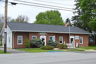
Carroll is a village in Fairfield County, Ohio, United States. The population was 501 at the 2020 census.

<span class="mw-page-title-main">Fairfield Beach, Ohio</span> Census-designated place in Ohio, United States

Fairfield Beach is an unincorporated community and census-designated place (CDP) in Fairfield County, Ohio, United States. The population was 1,267 at the 2020 census.

<span class="mw-page-title-main">Lithopolis, Ohio</span> Village in Ohio, United States

Lithopolis is a village in Fairfield and Franklin counties in the U.S. state of Ohio. The population was 2,134 at the 2020 census.

<span class="mw-page-title-main">Millersport, Ohio</span> Village in Ohio, United States

Millersport is a village in Fairfield County, Ohio, United States. The population was 978 at the 2020 census. Millersport is most notable as the home of the Sweet Corn Festival, which is held in Millersport annually during the first week of September.

<span class="mw-page-title-main">Stoutsville, Ohio</span> Village in Ohio, United States

Stoutsville is a village in Fairfield County, Ohio, United States. The population was 579 at the 2020 census.

<span class="mw-page-title-main">Sugar Grove, Ohio</span> Village in Ohio, United States

Sugar Grove is a village in Fairfield County, Ohio, United States. The population was 429 at the 2020 census.

<span class="mw-page-title-main">Thurston, Ohio</span> Village in Ohio, United States

Thurston is a village in Fairfield County, Ohio, United States. The population was 603 at the 2020 census.

<span class="mw-page-title-main">West Rushville, Ohio</span> Village in Ohio, United States

West Rushville is a village in Fairfield County, Ohio, United States. The population was 166 at the 2020 census.

<span class="mw-page-title-main">Leesburg, Ohio</span> Village in Ohio, United States

Leesburg is a village in Highland County, Ohio, United States. The population was 1,273 at the 2020 census.

<span class="mw-page-title-main">North Fairfield, Ohio</span> Village in Ohio, United States

North Fairfield is a village in Huron County, Ohio, United States. The population was 465 at the 2020 census.

<span class="mw-page-title-main">Fairfield, Vermont</span> Town in Vermont, United States

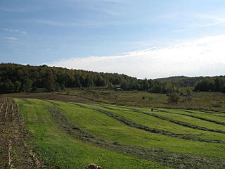
Fairfield is a town in Franklin County, Vermont, United States, chartered in 1763. The population was 2,044 at the 2020 census. President Chester A. Arthur was born in Fairfield in 1829, and lived there for the first three years of his life. A replica of his home, the Chester Alan Arthur State Historic Site, is open seasonally.

<span class="mw-page-title-main">Buckeye Lake, Ohio</span> Village in Ohio, United States

Buckeye Lake is a village in Fairfield and Licking counties in the U.S. state of Ohio. The population was 2,520 at the 2020 census. It is named for Buckeye Lake, a large lake along which the village is built.

References

  1. "ArcGIS REST Services Directory". United States Census Bureau. Retrieved September 20, 2022.
  2. 1 2 U.S. Geological Survey Geographic Names Information System: Pleasantville, Ohio
  3. 1 2 "U.S. Census website". United States Census Bureau . Retrieved January 31, 2008.
  4. Miller, Charles Christian (1912). History of Fairfield County, Ohio, and representative citizens. Chicago, Richmond-Arnold Pub. Co. p. 178.
  5. "Fairfield County". Jim Forte Postal History. Retrieved December 17, 2015.
  6. "US Gazetteer files 2010". United States Census Bureau. Archived from the original on January 25, 2012. Retrieved January 6, 2013.
  7. "Census of Population and Housing". Census.gov. Retrieved June 4, 2015.
  8. "U.S. Census website". United States Census Bureau . Retrieved January 6, 2013.