
Guadalupe Mountains National Park is an American national park in the Guadalupe Mountains, east of El Paso, Texas. The mountain range includes Guadalupe Peak, the highest point in Texas at 8,749 feet (2,667 m), and El Capitan used as a landmark by travelers on the route later followed by the Butterfield Overland Mail stagecoach line. The ruins of a stagecoach station stand near the Pine Springs visitor center. The restored Frijole Ranch contains a small museum of local history and is the trailhead for Smith Spring. The park covers 86,367 acres in the same mountain range as Carlsbad Caverns National Park, about 25 miles (40 km) to the north in New Mexico. The Guadalupe Peak Trail winds through pinyon pine and Douglas-fir forests as it ascends over 3,000 feet (910 m) to the summit of Guadalupe Peak, with views of El Capitan and the Chihuahuan Desert.

Malibu Creek State Park is a state park of California, United States, preserving the Malibu Creek canyon in the Santa Monica Mountains. The 8,215-acre (3,324 ha) park was established in 1974. Opened to the public in 1976, the park is also a component of Santa Monica Mountains National Recreation Area.

The geology of the Zion and Kolob canyons area includes nine known exposed formations, all visible in Zion National Park in the U.S. state of Utah. Together, these formations represent about 150 million years of mostly Mesozoic-aged sedimentation in that part of North America. Part of a super-sequence of rock units called the Grand Staircase, the formations exposed in the Zion and Kolob area were deposited in several different environments that range from the warm shallow seas of the Kaibab and Moenkopi formations, streams and lakes of the Chinle, Moenave, and Kayenta formations to the large deserts of the Navajo and Temple Cap formations and dry near shore environments of the Carmel Formation.

Henry W. Coe State Park is a state park of California, USA, preserving a vast tract of the Diablo Range. The park is located closest to the city of Morgan Hill, and is located in both Santa Clara and Stanislaus counties. The park contains over 87,000 acres (35,000 ha), making it the largest state park in northern California, and the second-largest in the state. Managed within its boundaries is a designated wilderness area of about 22,000 acres (8,900 ha). This is officially known as the Henry W. Coe State Wilderness, but locally as the Orestimba Wilderness. The 89,164-acre (36,083 ha) park was established in 1959.
North Central Arizona is a geographical region of Arizona. It is in the Transition Zone between the Basin and Range Province and the Colorado Plateau, and has some of the most rugged and scenic landscapes in Arizona.

The Simi Hills are a low rocky mountain range of the Transverse Ranges in eastern Ventura County and western Los Angeles County, of southern California, United States.
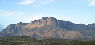
The Guadalupe Mountains are a mountain range located in West Texas and southeastern New Mexico. The range includes the highest summit in Texas, Guadalupe Peak, 8,751 ft (2,667 m), and the "signature peak" of West Texas, El Capitan, both of which are located within Guadalupe Mountains National Park. The Guadalupe Mountains are bordered by the Pecos River valley and Llano Estacado to the east and north, Delaware Mountains to the south, and Sacramento Mountains to the west.

Spring Mountain Ranch State Park is a public recreation area located within the Red Rock Canyon National Conservation Area in Nevada's Cottonwood Valley, five miles (8.0 km) northwest of Blue Diamond, Nevada. The state park preserves the historic Sandstone Ranch, which was entered into the National Register of Historic Places as a historic district in 1976.

Topanga State Park is a California state park located in the Santa Monica Mountains, within Los Angeles County, California. It is part of the Santa Monica Mountains National Recreation Area.

The Santa Monica Mountains National Recreation Area is a United States National Recreation Area containing many individual parks and open space preserves, located primarily in the Santa Monica Mountains of Southern California. The SMMNRA is located within the greater Los Angeles region, with two thirds of the parklands in northwest Los Angeles County, and the remaining third, including a Simi Hills extension, in southeastern Ventura County.

The Camelsfoot Range is a sub-range of the Chilcotin Ranges subdivision of the Pacific Ranges of the Coast Mountains in British Columbia. The Fraser River forms its eastern boundary. The range is approximately 90 km at its maximum length and less than 30 km wide at its widest.
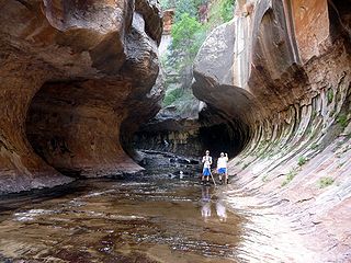
The Subway is a small, uniquely-shaped slot canyon within the Zion Wilderness in Zion National Park in northeastern Washington County, Utah, United States.

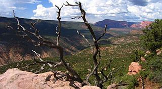
Kolob Canyons is the northwest section of Zion National Park of Utah, United States. The Kolob Canyons are part of the Colorado Plateau region of the park and are noted for their colorful beauty and diverse landscape. This part of Zion National Park is accessed by a park road about 20 miles south of Cedar City, Utah off Interstate 15.
LaVerkin Creek Wilderness is a 445-acre (1.8 km2) wilderness area in the US state of Utah. It was designated March 30, 2009, as part of the Omnibus Public Land Management Act of 2009. Located adjacent to the Kolob Canyons region of Zion National Park, it encompasses and protects the upper headwaters of LaVerkin Creek, a tributary of the Wild & Scenic Virgin River. Another portion of the creek is protected by the Blackridge Canyon Wilderness. LaVerkin Creek Wilderness is bordered by the Zion Wilderness to the south.
Beartrap Canyon Wilderness is a 40-acre (0.2 km2) wilderness area in the US state of Utah. It was designated March 30, 2009, as part of the Omnibus Public Land Management Act of 2009. Located adjacent to the Kolob Canyons region of Zion National Park, it encompasses and protects part of Beartrap Canyon Creek, a tributary of the Wild & Scenic Virgin River. Beartrap Canyon Wilderness is bordered by the Zion Wilderness to the east.
Blackridge Wilderness is a 13,108-acre (5,305 ha) wilderness area in the state of Utah. It was designated March 30, 2009, as part of the Omnibus Public Land Management Act of 2009. Located adjacent to the Kolob Canyons section of Zion National Park, it protects a Black Ridge, formed by the Hurricane Fault, as well as a long stretch of LaVerkin Creek, a tributary of the Wild and Scenic Virgin River. Blackridge Wilderness is bordered by the Zion Wilderness to the northeast.

Kolob Creek Dam is a dam in Washington County, Utah.

Bonita Canyon is a box canyon on the western slope of the Chiricahua Mountains in southeastern Arizona, which lies at 5,360 feet (1,630 m) in elevation and opens in a southwesterly direction into the Sulphur Springs Valley.

