
Butler Township is a township in Luzerne County, Pennsylvania, United States. The population was 9,469 at the 2020 census.
Hazle Township is a township in Luzerne County, Pennsylvania, United States. The population was 10,150 at the time of the 2020 census. The township surrounds the city of Hazleton and the borough of West Hazleton.

Hazleton is a city in Luzerne County, Pennsylvania, United States. The population was 29,963 at the 2020 census. Hazleton is the second largest city in Luzerne County. It was incorporated as a borough on January 5, 1857, and as a city on December 4, 1891.

Jeddo is a borough in Luzerne County, Pennsylvania, United States. As of the 2020 census, the population was 109, making it the least populous borough in the county.

West Hazleton is a borough in Luzerne County, Pennsylvania, United States. The borough is 31 miles (50 km) south of Wilkes Barre and had a population of 5,167 as of the 2020 census.
Kline Township is a township in Schuylkill County, Pennsylvania. The population was 1,473 at the 2020 census.

Sugar Creek is a waterway located in the U.S. state of Indiana. It originates in a farm field approximately two miles south of Kempton, Indiana, and travels west-southwest for about 93 miles (150 km) before merging with the Wabash River 5 miles (8.0 km) north of Montezuma. The largest community on the waterway is Crawfordsville.

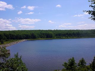
Black Creek is a long source tributary of Nescopeck Creek so part of the Susquehanna River drainage basin. It is also the second & longer stream of the same name recognized by the USGS GNIS system in Luzerne County, Pennsylvania, in the United States—compared to the Black Creek beyond the ridgeline of the drainage divide, so in the Lehigh River valley and Carbon County. The headwaters of both Black Creeks in Luzerne county are only a few miles apart, and both valleys were traversed by the Lausanne-Nescopeck Turnpike in the first half of the 19th-century.
Pennsylvania State Senate District 29 includes part of Luzerne County and all of Carbon County and Schuylkill County. It is currently represented by Republican Dave Argall.

Harleigh is a census-designated place (CDP) in Hazle Township, Luzerne County, Pennsylvania, United States, north of the city of Hazleton. The CDP population was 1,104 at the 2010 census.

Otter Creek Township is one of the twenty-one townships of Tama County, Iowa, United States.
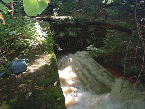
The Jeddo Tunnel is a drainage tunnel at water level in Pennsylvania. It is one of the Coal Region's biggest discharges of mine water. The tunnel is five miles long and was constructed between 1891 and 1894, and at the time of its construction, was reputed to be the largest mine drainage tunnel in the world. It consists of major tunnels A and B, and minor tunnels C, D and X.

Little Nescopeck Creek is a tributary of Nescopeck Creek in Luzerne County, Pennsylvania, in the United States. It is approximately 8.5 miles (13.7 km) long and flows through Butler Township, Sugarloaf Township, and Conyngham. The watershed of the creek has an area of 14.0 square miles (36 km2). The creek is acidic and receives mine water from the Jeddo Tunnel. The main rock formation in the watershed is the Mauch Chunk Formation. However, the Pottsville Formation also appears in some areas. Soil series in the drainage basin include the Arnot Series, the Basher Series, and various other soil types.
The Green Mountain Tunnel is a mine drainage tunnel in Schuylkill County, Pennsylvania, in the United States. It is one of five major mine drainage tunnels in the watershed of Catawissa Creek. The tunnel discharges into Catawissa Creek near the Audenried Tunnel and the Catawissa Tunnel. The tunnel was constructed in the 1930s and is slightly less than one mile long.
Little Black Creek is a tributary of Black Creek in Luzerne County, Pennsylvania, in the United States. It is approximately 2.2 miles (3.5 km) long and flows through Lattimer, Harleigh, and Hazle Township. The watershed of the creek is largely on coal mining land. It only has an intermittent flow and some of its waters drain into the Jeddo Tunnel instead of Black Creek. The creek is in the Eastern Middle Anthracite Field. There is at least one bridge crossing the creek.
Cranberry Creek is a tributary of Stony Creek in Luzerne County, Pennsylvania, in the United States. It is approximately 4.4 miles (7.1 km) long and flows through Hazle Township. The creek is affected by acid mine drainage. It also contains metals such as iron, manganese, and aluminum. It is in the drainage basin of the Jeddo Tunnel. Major roads in the creek's watershed include Pennsylvania Route 924, Pennsylvania Route 309, and Interstate 81. At least one bridge has been built over it. The creek has undergone restoration and there are plans to construct an area known as the Cranberry Creek Gateway Park in its vicinity.
Pony Creek is a stream in the U.S. state of Indiana.
Louisa is an extinct town in southern Texas County, in the U.S. state of Missouri. The community was located along the South Prong of Jacks Fork Creek, southeast of Grogan.
Hazle Creek is an American tributary source stream of the Lehigh and Delaware Rivers in the Commonwealth of Pennsylvania in the United States.

Ebervale is an unincorporated community located in Hazle Township in Luzerne County, Pennsylvania. Ebervale is located along Pennsylvania Route 940, northeast of Hazleton and west of Jeddo. The village takes its name from an Anglicization of the place name Ebbw Vale, a town in Wales.

