
The Allegheny River is a 325-mile (523 km) long headwater stream of the Ohio River in western Pennsylvania and New York, United States. The Allegheny River runs from its headwaters just below the middle of Pennsylvania's northern border northwesterly into New York then in a zigzag southwesterly across the border and through Western Pennsylvania to join the Monongahela River at the Forks of the Ohio on the "Point" of Point State Park in Downtown Pittsburgh, Pennsylvania. The Allegheny River is, by volume, the main headstream of both the Ohio and Mississippi Rivers. Historically, the Allegheny was considered to be the upper Ohio River by both Native Americans and European settlers.

Ohiopyle is a borough in Fayette County, Pennsylvania, United States. The population was 59 at the 2010 census. While Ohiopyle has a tiny year-round population, it is often filled with tourists on the weekend, who come for the outdoor recreation opportunities at the surrounding Ohiopyle State Park, as well as the Great Allegheny Passage bicycle trail which connects with the Chesapeake and Ohio Canal towpath trail to form a continuous 335-mile off-road trail from Pittsburgh, Pennsylvania to Washington, D.C. The borough of Ohiopyle is served by the Uniontown Area School District.

Punxsutawney is a borough in the south of Jefferson County, Pennsylvania, United States. Punxsutawney is known for its Groundhog Day celebration each February 2, during which thousands of attendees and international media outlets visit the town for an annual weather prediction by the groundhog Punxsutawney Phil.

Mountain Top is an unincorporated area and census-designated place (CDP) in Luzerne County, Pennsylvania, United States. As of the 2010 census, the CDP population was 10,982.

Conshohocken is a borough on the Schuylkill River in Montgomery County, Pennsylvania, in suburban Philadelphia. Historically a large mill town and industrial and manufacturing center, after the decline of industry in recent years Conshohocken has developed into a center of riverfront commercial and residential development. In the regional slang, it is sometimes referred to by the colloquial nickname Conshy. The name "Conshohocken" comes from the Unami language, from either Kanshi'hak'ing, meaning "Elegant-ground- place", or, more likely, Chottschinschu'hak'ing, which means "Big-trough-ground-place" or "Large-bowl-ground-place", referring to the big bend in the Tulpe'hanna.

The Lenape, also called the Leni Lenape, Lenni Lenape and Delaware people, are an indigenous people of the Northeastern Woodlands, who live in the United States and Canada. Their historical territory included present-day New Jersey and eastern Pennsylvania along the Delaware River watershed, New York City, western Long Island, and the Lower Hudson Valley. Today, Lenape people belong to the Delaware Nation and Delaware Tribe of Indians in Oklahoma; the Stockbridge-Munsee Community in Wisconsin; and the Munsee-Delaware Nation, Moravian of the Thames First Nation, and Delaware of Six Nations in Ontario.

The Susquehanna River is a major river located in the northeastern and mid-Atlantic United States. At 444 miles (715 km) long, it is the longest river on the East Coast of the United States. It drains into the Chesapeake Bay. With its watershed, it is the 16th-largest river in the United States, and the longest river in the early 21st-century continental United States without commercial boat traffic.

The Conemaugh River is a 70-mile (110 km) long tributary of the Kiskiminetas River in Westmoreland, Indiana, and Cambria counties in the U.S. state of Pennsylvania. The name means 'Otter Creek', originating from the Unami-Lenape language word kwənəmuxkw 'otter'.

Kittanning was an 18th-century Native American village in the Ohio Country, located on the Allegheny River at present-day Kittanning, Pennsylvania. The village was at the western terminus of the Kittanning Path, an Indian trail that provided a route across the Alleghenies between the Ohio and Susquehanna river basins. The village, inhabited by Delaware (Lenape) and Shawnee Indians, was most likely the largest such village on the western side of the Alleghenies at the time, having an estimated 300–400 residents in 1756. Kittanning was settled in 1724 by Indians who had migrated from eastern Pennsylvania as white settlement rapidly expanded.
Quittapahilla Creek is a 16.8-mile-long (27.0 km) tributary of Swatara Creek in south-central Pennsylvania in the United States. The original Lenape name for this waterway is Kuwektəpehəle, which means 'it flows out (ktəpehəle) from the pines (kuwe)'.

The West Branch Susquehanna River is one of the two principal branches, along with the North Branch, of the Susquehanna River in the northeastern United States. The North Branch, which rises in upstate New York, is generally regarded as the extension of the main branch, with the shorter West Branch being its principal tributary. The West Branch, which is 243 miles (391 km) long, is entirely within the state of Pennsylvania, draining a large mountainous area within the Allegheny Plateau in the western part of the state. Along most of its course it meanders along mountain ridges and through water gaps, forming a large zigzag arc through central Pennsylvania around the north end of the Allegheny Ridge. In colonial times the river provided an important water route to the Ohio River valley. In the 18th century, its lower valley became a significant industrial heartland of Pennsylvania. In the 20th century, the upper reaches of the West Branch turned a yellow/orange color due to sulfurous drainage from nearby and abandoned deep bituminous coal mines.
The Delaware languages, also known as the Lenape languages, are Munsee and Unami, two closely related languages of the Eastern Algonquian subgroup of the Algonquian language family. Munsee and Unami, spoken aboriginally by the Lenape people in the vicinity of the modern New York City area in the United States, including western Long Island, Manhattan Island, Staten Island, as well as adjacent areas on the mainland: southeastern New York State, eastern Pennsylvania, New Jersey, Connecticut, Maryland, and Delaware.

Passyunk Township is a defunct township that was located in Philadelphia County, Pennsylvania. The township ceased to exist and was incorporated into the City of Philadelphia following the passage of the Act of Consolidation, 1854.

Big Wapwallopen Creek is a tributary of the Susquehanna River in Luzerne County, Pennsylvania, in the United States. It is approximately 23 miles (37 km) long and flows through Bear Creek Township, Fairview Township, Rice Township, Wright Township, Dorrance Township, Hollenback Township, Nescopeck Township, and Conyngham Township. The watershed of the creek has an area of 53.2 square miles (138 km2). The creek has three named tributaries: Balliet Run, Watering Run, and Bow Creek. The creek is designated as a Coldwater Fishery and a Migratory Fishery and is also Class A Wild Trout Waters for part of its length. However, a portion is considered to be impaired by organic enrichment and/or low levels of dissolved oxygen and its pH ranges from moderately acidic to slightly alkaline.

Sinnemahoning Creek is a 15.7-mile-long (25.3 km) tributary of the West Branch Susquehanna River in Cameron and Clinton counties, Pennsylvania, in the United States.

Pennsylvania Route 239 (PA 239) is a 36.84-mile-long (59.29 km) state highway located in Luzerne, Columbia and Lycoming Counties in Pennsylvania. The southern terminus is at PA 93 in Nescopeck Township. The northern terminus is at PA 42 in North Mountain. The route heads north from PA 93 and parallels the Susquehanna River between Wapwallopen and Mocanaqua before crossing the river into Shickshinny and forming a concurrency with U.S. Route 11 (US 11). Past Shickshinny, PA 239 runs west through rural areas to Benton, where it has a concurrency with PA 487. The route continues northwest and crosses PA 118 before it reaches its northern terminus.
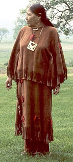
Nora Thompson Dean, also known as Weenjipahkihelexkwe, which translates as "Touching Leaves Woman" in Unami, was a member of the Delaware Tribe of Indians. As a Lenape traditionalist and one of the last fluent speakers of the southern Unami dialect of the Lenape language, she was an influential mentor to younger tribal members and is widely cited in scholarship on Lenape culture.

Lenape is an unincorporated community in Pocopson Township in Chester County, Pennsylvania, United States. Lenape is centered on the intersection of Pennsylvania Route 52 and Pocopson Road west of the Brandywine Creek.

Watering Run is a tributary of Big Wapwallopen Creek in Luzerne County, Pennsylvania, in the United States. It is approximately 4.2 miles (6.8 km) long and flows through Wright Township. The watershed of the stream has an area of 3.87 square miles (10.0 km2). Soils in the vicinity of the stream include Morris Silt Loam, Braceville and Chenango Gravelly Loams, Oquaga and Lordstown Silt Loams, and Rexford Loam. The stream is designated as a Coldwater Fishery. It flooded in 1972.


 Pennsylvania Route 239 in Wapwallopen
