Kirkland, North Carolina

Last updated

Kirkland, North Carolina
CDP
New Hanover County North Carolina incorporated and unincorporated areas Porters Neck highlighted.svg
Location in New Hanover County and the state of North Carolina.
Coordinates: 34°19′02″N77°47′48″W / 34.31722°N 77.79667°W / 34.31722; -77.79667
Country United States
State North Carolina
County New Hanover
Area
  Total8.4 sq mi (21.8 km2)
  Land8.4 sq mi (21.7 km2)
  Water0.0 sq mi (0.1 km2)
Elevation
[1]
43 ft (13 m)
Population
 (2020)
  Total7,397
Time zone UTC-5 (Eastern (EST))
  Summer (DST) UTC-4 (EDT)
FIPS code 37-35975 [2]
GNIS feature ID2403179 [1]

Kirkland, more commonly known as Porter's Neck, was a census-designated place (CDP) in New Hanover County, North Carolina, United States. Redesignated as Porters Neck CDP for the 2010 census, the population was 6,204. It is part of the Wilmington Metropolitan Statistical Area.

Contents

Geography

According to the United States Census Bureau, the CDP has a total area of 8.4 square miles (22 km2), of which 8.4 square miles (22 km2) is land and 0.04 square miles (0.10 km2) (0.24%) is water.

Demographics

2020 census

Porters Neck racial composition [3]
RaceNumberPercentage
White (non-Hispanic)6,54888.52%
Black or African American (non-Hispanic)2172.93%
Native American 90.12%
Asian 1101.49%
Pacific Islander 20.03%
Other/Mixed 2583.49%
Hispanic or Latino 2533.42%

As of the 2020 United States census, there were 7,397 people, 3,087 households, and 2,282 families residing in the CDP.

2000 census

As of the census [2] of 2000, there were 579 people, 212 households, and 160 families residing in the CDP. The population density was 69.0 inhabitants per square mile (26.6/km2). There were 231 housing units at an average density of 27.5 per square mile (10.6/km2). The racial makeup of the CDP was 64.08% White, 33.85% African American, 0.17% Native American, 0.35% Asian, and 1.55% from two or more races. Hispanic or Latino of any race were 2.07% of the population.

There were 212 households, out of which 33.0% had children under the age of 18 living with them, 59.0% were married couples living together, 12.3% had a female householder with no husband present, and 24.5% were non-families. 21.7% of all households were made up of individuals, and 5.7% had someone living alone who was 65 years of age or older. The average household size was 2.73 and the average family size was 3.18.

In the CDP, the population was spread out, with 24.5% under the age of 18, 6.2% from 18 to 24, 30.9% from 25 to 44, 28.5% from 45 to 64, and 9.8% who were 65 years of age or older. The median age was 38 years. For every 100 females, there were 96.3 males. For every 100 females age 18 and over, there were 95.1 males.

The median income for a household in the CDP was $56,292, and the median income for a family was $57,083. Males had a median income of $34,063 versus $22,614 for females. The per capita income for the CDP was $21,439. About 8.2% of families and 10.2% of the population were below the poverty line, including none of those under age 18 and 15.9% of those age 65 or over.

Related Research Articles

<span class="mw-page-title-main">Underwood-Petersville, Alabama</span> Census-designated place in Alabama, United States

Underwood-Petersville is a census-designated place (CDP) in Lauderdale County, Alabama United States. It is part of the Florence - Muscle Shoals Metropolitan Statistical Area known as "The Shoals". As of the 2010 census, the population of the CDP is 3,247.

<span class="mw-page-title-main">Tucson Estates, Arizona</span> CDP in Arizona, United States

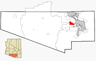
Tucson Estates is a census-designated place (CDP) in Pima County, Arizona, United States. The population was 9,755 at the 2000 census.

Goodings Grove was a census-designated place in northern Will County, Illinois, United States. The population was 17,084 at the 2000 census. It is now a neighborhood of the village of Homer Glen, Illinois, which was incorporated in 2001.

<span class="mw-page-title-main">Hillsmere Shores, Maryland</span> Former census-designated place in Maryland, United States

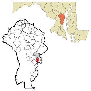
Hillsmere Shores was a census-designated place (CDP) in Anne Arundel County, Maryland, United States. It is a suburb of Annapolis. The population was 2,977 at the 2000 census. It was included in the Annapolis Neck CDP at the 2010 census. Built in phases, beginning in 1960, the community has been home to The Key School, a non-sectarian private school, since the 1960s.

<span class="mw-page-title-main">Mount Lena, Maryland</span> CDP in Maryland, United States

Mount Lena is a census-designated place (CDP) in Washington County, Maryland, United States. The population was 501 at the 2000 census.

<span class="mw-page-title-main">Mashpee Neck, Massachusetts</span> Census-designated place in Massachusetts, United States

Mashpee Neck is a census-designated place (CDP) in the town of Mashpee in Barnstable County, Massachusetts, United States. The population was 1,000 at the 2010 census. It is the most populous of the seven CDPs in Mashpee.

<span class="mw-page-title-main">Sanostee, New Mexico</span> CDP in New Mexico, United States

Sanostee is a census-designated place (CDP) in San Juan County, New Mexico, United States. The population was 429 at the 2000 census. It is part of the Farmington Metropolitan Statistical Area.

Clark Mills is a hamlet in Oneida County, New York, United States. The population was 1,905 at the 2010 census.

<span class="mw-page-title-main">Eatons Neck, New York</span> Hamlet and census-designated place in New York, United States

Eatons Neck is a hamlet and census-designated place (CDP) in the Town of Huntington in Suffolk County, on the North Shore of Long Island, in New York, United States. The population was 1,406 at the 2010 census.

<span class="mw-page-title-main">Moriches, New York</span> Hamlet and census-designated place in New York, United States

Moriches is a hamlet and census-designated place (CDP) in the Suffolk County town of Brookhaven, New York, United States. The population was 2,838 at the 2010 census.

<span class="mw-page-title-main">Ogden, North Carolina</span> CDP in North Carolina, United States

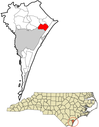
Ogden is a census-designated place (CDP) in New Hanover County, North Carolina, United States. It is both a suburb of the city of Wilmington and part of the Wilmington Metropolitan Statistical Area. The population was 6,766 at the 2010 census, up from 5,481 in 2000.

Raemon is a census-designated place (CDP) in Robeson County, North Carolina, United States. The population was 212 at the 2000 census.

<span class="mw-page-title-main">Northbrook, Ohio</span> Census-designated place in Ohio, United States

Northbrook is a census-designated place (CDP) in Hamilton County, Ohio, United States. The population was 10,912 at the 2020 census.

<span class="mw-page-title-main">Lenape Heights, Pennsylvania</span> Census-designated place in Pennsylvania, United States

Lenape Heights is a census-designated place (CDP) in Armstrong County, Pennsylvania, United States. The population was 1,144 at the 2020 census.

<span class="mw-page-title-main">Orchard Hills, Pennsylvania</span> Census-designated place in Pennsylvania, United States

Orchard Hills is a census-designated place (CDP) in Armstrong County, Pennsylvania, United States. The population was 1,949 at the 2020 census.

<span class="mw-page-title-main">Lake Shore, Utah</span> CDP in Utah, United States

Lake Shore is a census-designated place (CDP) in Utah County, Utah, United States. It is part of the Provo–Orem Metropolitan Statistical Area. The population was 817 at the 2010 census.

<span class="mw-page-title-main">Inglewood-Finn Hill, Washington</span> Neighborhood in King, Washington, United States

Inglewood-Finn Hill was a census-designated place (CDP) in King County, Washington, United States. The population was 22,707 at the 2010 census. The community was largely annexed into neighboring Kirkland in 2011.

<span class="mw-page-title-main">Kingsgate, Kirkland, Washington</span> Neighborhood in King, Washington, United States

Kingsgate is a neighborhood of Kirkland, Washington, United States. It was annexed by Kirkland on June 1, 2011. Prior to the annexation, Kingsgate was a census-designated place (CDP).

<span class="mw-page-title-main">Bourne (CDP), Massachusetts</span> Census-designated place in Massachusetts, United States

The village of Bourne is a census-designated place (CDP) in the town of Bourne in Barnstable County, Massachusetts, United States. The population was 1,418 at the 2010 census, out of 19,754 in the town of Bourne as a whole.

Machias is a census-designated place (CDP) corresponding to the central village area within the town of Machias in Washington County, Maine, United States. The population of the CDP was 1,274 at the 2010 census.

References

  1. 1 2 U.S. Geological Survey Geographic Names Information System: Kirkland, North Carolina
  2. 1 2 "U.S. Census website". United States Census Bureau . Retrieved January 31, 2008.
  3. "Explore Census Data". data.census.gov. Retrieved December 24, 2021.