Silver Lake, North Carolina

Last updated

Silver Lake, North Carolina
CDP
New Hanover County North Carolina incorporated and unincorporated areas Silver Lake highlighted.svg
Location in New Hanover County and the state of North Carolina.
Coordinates: 34°08′27″N77°54′32″W / 34.14083°N 77.90889°W / 34.14083; -77.90889
Country United States
State North Carolina
County New Hanover
Area
[1]
  Total2.50 sq mi (6.48 km2)
  Land2.47 sq mi (6.39 km2)
  Water0.04 sq mi (0.09 km2)
Elevation
[2]
13 ft (4 m)
Population
 (2020)
  Total6,500
  Density2,635.85/sq mi (1,017.72/km2)
Time zone UTC-5 (Eastern (EST))
  Summer (DST) UTC-4 (EDT)
ZIP code
28412 [3]
Area codes 910, 472
FIPS code 37-61950 [4]
GNIS feature ID2402855 [2]

Silver Lake is a census-designated place in New Hanover County, North Carolina, United States. The population was 5,598 at the 2010 census, down from 5,788 in 2000. It is part of the Wilmington Metropolitan Statistical Area.

Contents

Geography

According to the United States Census Bureau, the CDP has a total area of 6.6 square miles (17 km2), of which 6.6 square miles (17.0 km2) is land and 0.15% is water.

Demographics

Historical population
CensusPop.Note
2020 6,500
U.S. Decennial Census [5]

As of the census [4] of 2000, there were 5,788 people, 2,280 households, and 1,566 families residing in the CDP. The population density was 882.0 inhabitants per square mile (340.5/km2). There were 2,449 housing units at an average density of 373.2 per square mile (144.1/km2). The racial makeup of the CDP was 88.23% White, 8.00% African American, 0.59% Native American, 1.21% Asian, 0.10% Pacific Islander, 0.81% from other races, and 1.05% from two or more races. Hispanic or Latino of any race were 2.16% of the population.

There were 2,280 households, out of which 33.9% had children under the age of 18 living with them, 54.2% were married couples living together, 10.9% had a female householder with no husband present, and 31.3% were non-families. 21.7% of all households were made up of individuals, and 3.6% had someone living alone who was 65 years of age or older. The average household size was 2.51 and the average family size was 2.97.

In the CDP, the population was spread out, with 25.2% under the age of 18, 9.5% from 18 to 24, 35.1% from 25 to 44, 22.5% from 45 to 64, and 7.7% who were 65 years of age or older. The median age was 33 years. For every 100 females, there were 93.1 males. For every 100 females age 18 and over, there were 89.7 males.

The median income for a household in the CDP was $41,732, and the median income for a family was $49,434. Males had a median income of $36,631 versus $22,444 for females. The per capita income for the CDP was $19,609. About 4.5% of families and 9.1% of the population were below the poverty line, including 6.3% of those under age 18 and 7.2% of those age 65 or over.

Related Research Articles

<span class="mw-page-title-main">Sun Lakes, Arizona</span> CDP in Maricopa County, Arizona

Sun Lakes is an unincorporated community and census-designated place (CDP) in Maricopa County, Arizona, United States. The population was 14,868 at the 2020 census. Sun Lakes is an active adult community comprising five country club communities in three homeowner associations. These include the gated communities of Oakwood and IronWood (IronOaks), the gated and non-gated communities of Palo Verde and Cottonwood, and the non-gated community of Sun Lakes 1. Sun Lakes is a master-planned community developed by Robson Communities.

<span class="mw-page-title-main">Silver Lake, Florida</span> Census-designated place in Florida

Silver Lake is a census-designated place (CDP) in Lake County, Florida, United States. The population was 1,879 at the 2010 census. It is part of the Orlando–Kissimmee Metropolitan Statistical Area.

<span class="mw-page-title-main">Silver Springs Shores, Florida</span> Census-designated place in Florida, United States

Silver Springs Shores is a census-designated place (CDP) in Marion County, Florida, United States. The population was 24,846 at the 2020 census. It is part of the Ocala Metropolitan Statistical Area.

Forest Lake is an unincorporated community and census-designated place (CDP) in Ela Township of Lake County, Illinois, United States. It is about 35 miles (56 km) northwest of downtown Chicago. Per the 2020 census, the population was 1,784. The community was founded in 1935 as a vacation community for Chicago residents.

Gages Lake is a census-designated place (CDP) in Warren Township, Lake County, Illinois, United States. The population was 10,637 at the 2020 census.

Lake Catherine is an unincorporated community and census-designated place (CDP) in Lake County, Illinois, United States. Per the 2020 census, the population was 1,279.

Long Lake is an unincorporated community and census-designated place (CDP) in Lake County, Illinois, United States. Per the 2020 census, the population was 3,663.

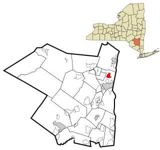
Venetian Village is a census-designated place (CDP) in Lake County, Illinois, United States. Per the 2020 census, the population was 2,761.

<span class="mw-page-title-main">Lake Summerset, Illinois</span> Census Designated Place in Illinois, United States

Lake Summerset is a census-designated place (CDP) in Stephenson and Winnebago counties in Illinois. The population was 2,048 at the 2010 census.

<span class="mw-page-title-main">Argentine, Michigan</span> Census-designated place & unincorporated community in Michigan, United States

Argentine is an unincorporated community and census-designated place (CDP) in Argentine Township, Genesee County, in the U.S. state of Michigan. The population was 2,685 as of the 2020 census, up from 2,525 at the 2010 census. It was first settled in 1836.

<span class="mw-page-title-main">Arnold, Minnesota</span> Census-designated place in Minnesota, US

Arnold is a former census-designated place (CDP), which was located in Rice Lake, Saint Louis County, Minnesota, United States. The population was 2,960 at the 2010 census. The census-designated place of Arnold was located entirely within the former Rice Lake Township, adjacent to the north side of the city of Duluth. Rice Lake Township was incorporated as the city of Rice Lake on October 22, 2015, thus rendering the census-designated place of Arnold to no longer exist.

<span class="mw-page-title-main">Oakville, Missouri</span> CDP in Missouri, United States

Oakville is a census-designated place (CDP) in south St. Louis County, Missouri, United States. The population was 36,301 at the 2020 census. Oakville is 18 miles south of the city of St. Louis and borders the Mississippi and Meramec rivers; the area is part of "South County".

<span class="mw-page-title-main">Angola on the Lake, New York</span> Census-designated place in New York, United States

Angola on the Lake is a hamlet and census-designated place (CDP) in Erie County, New York, United States. The population was 1,675 at the 2010 census. It is part of the Buffalo–Niagara Falls Metropolitan Statistical Area.

<span class="mw-page-title-main">Tuckahoe, Suffolk County, New York</span> Hamlet and census-designated place in New York, United States

Tuckahoe is a hamlet and census-designated place (CDP) in the Town of Southampton, Suffolk County, New York, United States. The population was 1,373 at the 2010 census.

<span class="mw-page-title-main">Lake Katrine, New York</span> CDP in New York, United States

Lake Katrine is a hamlet in Ulster County, New York, United States. The population was 2,522 at the 2020 census.

<span class="mw-page-title-main">Canadohta Lake, Pennsylvania</span> Census-designated place in Pennsylvania, United States

Canadohta Lake is a census-designated place (CDP) in Crawford County, Pennsylvania, United States. The population was 516 at the 2010 census.

<span class="mw-page-title-main">Lake Wynonah, Pennsylvania</span> CDP in Pennsylvania, United States

Lake Wynonah is a census-designated place (CDP) in Schuylkill County, Pennsylvania, United States. The population was 1,961 at the 2000 census, and 2,640 at the 2010 census. Lake Wynonah is a gated community with two lakes, Fawn Lake and Lake Wynonah, and as of July 2008, there are over 1200 homes and 1500 members. It is in South Manheim and Wayne Townships.

<span class="mw-page-title-main">Lake Bosworth, Washington</span> CDP in Washington, United States

Lake Bosworth is a census-designated place (CDP) in Snohomish County, Washington, United States. The population was 667 at the 2010 census.

<span class="mw-page-title-main">Martha Lake, Washington</span> CDP in Washington, United States

Martha Lake is a census-designated place (CDP) in Snohomish County, Washington, United States. The population was 21,129 at the 2020 census. It lies west of Mill Creek and northeast of Lynnwood, near the lake of the same name.

<span class="mw-page-title-main">Lake Wissota, Wisconsin</span> CDP in Wisconsin, United States

Lake Wissota is a census-designated place (CDP) in the town of Lafayette in Chippewa County in the U.S. state of Wisconsin. The population was 2,738 at the 2010 census. The CDP, known locally as Lake Wissota Village, is located along the southern shores of Lake Wissota.

References

  1. "ArcGIS REST Services Directory". United States Census Bureau. Retrieved September 20, 2022.
  2. 1 2 U.S. Geological Survey Geographic Names Information System: Silver Lake, North Carolina
  3. "Silver Lake ZIP Code". zipdatamaps.com. 2023. Retrieved January 12, 2023.
  4. 1 2 "U.S. Census website". United States Census Bureau . Retrieved January 31, 2008.
  5. "Census of Population and Housing". Census.gov. Retrieved June 4, 2016.